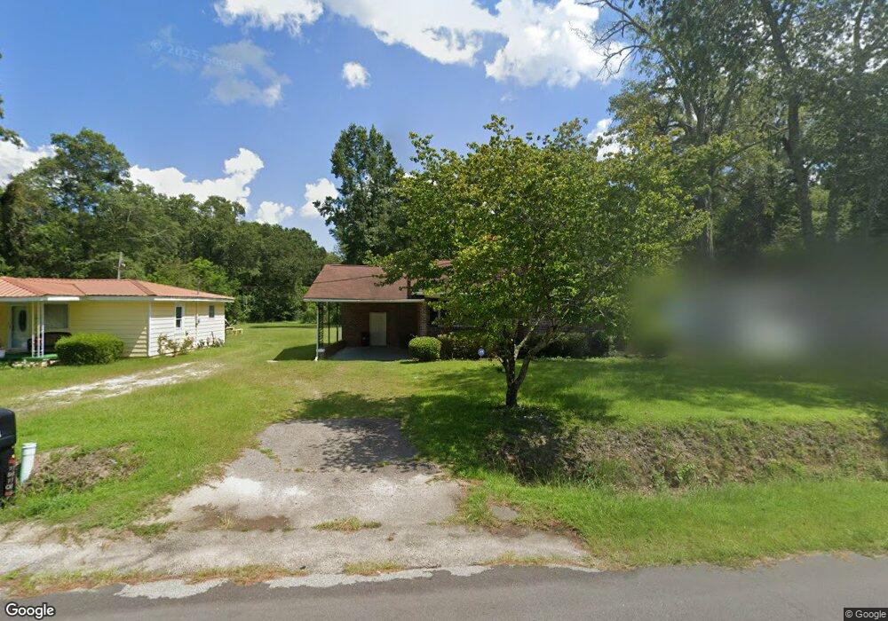
1910 Myers Rd Orangeburg, SC 29115
Estimated Value: $107,879 - $129,000
3
Beds
1
Bath
1,500
Sq Ft
$77/Sq Ft
Est. Value
About This Home
This home is located at 1910 Myers Rd, Orangeburg, SC 29115 and is currently estimated at $116,220, approximately $77 per square foot. 1910 Myers Rd is a home located in Orangeburg County with nearby schools including Whittaker Elementary School, Whittaker Elementary, and Robert E. Howard Middle School.
Ownership History
Date
Name
Owned For
Owner Type
Purchase Details
Closed on
Aug 2, 2019
Sold by
Davis Marumba
Bought by
Davis Gerald A
Current Estimated Value
Purchase Details
Closed on
Dec 12, 2014
Sold by
Jennings Sinclair and Burke Leslie Jennings
Bought by
Davis Gerald A and Davis Marumba
Home Financials for this Owner
Home Financials are based on the most recent Mortgage that was taken out on this home.
Original Mortgage
$51,750
Outstanding Balance
$39,815
Interest Rate
4.04%
Mortgage Type
New Conventional
Estimated Equity
$76,405
Create a Home Valuation Report for This Property
The Home Valuation Report is an in-depth analysis detailing your home's value as well as a comparison with similar homes in the area
Home Values in the Area
Average Home Value in this Area
Purchase History
| Date | Buyer | Sale Price | Title Company |
|---|---|---|---|
| Davis Gerald A | -- | None Available | |
| Davis Gerald A | $57,500 | -- |
Source: Public Records
Mortgage History
| Date | Status | Borrower | Loan Amount |
|---|---|---|---|
| Open | Davis Gerald A | $51,750 |
Source: Public Records
Tax History Compared to Growth
Tax History
| Year | Tax Paid | Tax Assessment Tax Assessment Total Assessment is a certain percentage of the fair market value that is determined by local assessors to be the total taxable value of land and additions on the property. | Land | Improvement |
|---|---|---|---|---|
| 2024 | $1,666 | $4,881 | $393 | $4,488 |
| 2023 | $1,396 | $3,514 | $340 | $3,174 |
| 2022 | $1,393 | $3,514 | $340 | $3,174 |
| 2021 | $1,386 | $3,514 | $340 | $3,174 |
| 2020 | $1,273 | $3,514 | $0 | $0 |
| 2019 | $1,231 | $3,514 | $0 | $0 |
| 2018 | $1,288 | $3,370 | $0 | $0 |
| 2017 | $1,270 | $3,370 | $0 | $0 |
| 2016 | $1,268 | $3,370 | $0 | $0 |
| 2015 | $1,206 | $3,370 | $0 | $0 |
| 2014 | $1,206 | $3,370 | $340 | $3,030 |
| 2013 | -- | $0 | $0 | $0 |
Source: Public Records
Map
Nearby Homes
- 1859 Atlantic Ave
- 1825 Atlantic Ave
- 2015 Atlantic Ave
- 2031 Atlantic Ave
- 0 Whittaker Pkwy Unit 25025172
- 925 Chitwood St
- 1832par Co Par Ct
- 1832 Par Ct
- 2266 Atlantic Ave
- 0 Bryan Dr
- 1582 Washington St
- 0 Corona Dr Unit 25006444
- 1542 Belleville Rd
- 0 Aaron St
- 0 Old Cameron Rd
- 344 Mingo St
- 995 Carson St SE
- 550 Bleakley St SE
- 2466 Old Cameron Rd
- 0000 Oc 1207