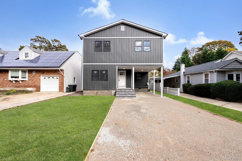
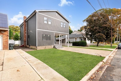
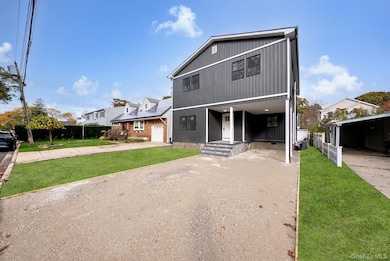

1911 Carroll Ave Merrick, NY 11566
Estimated payment $5,935/month
Highlights
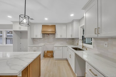
- Eat-In Gourmet Kitchen
- Open Floorplan
- Main Floor Bedroom
- Burcham Elementary School Rated 10
- Colonial Architecture
- Formal Dining Room
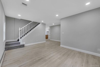
About This Home
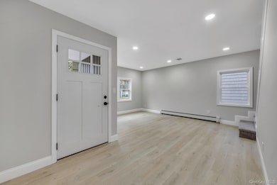
Fully renovated 6-bed, 3-bath home in the heart of Merrick! Brand new inside and out. Premium sidings, black windows, new boiler & mechanical. Features a stunning two-tone kitchen with quartz counters, shaker cabinets & stainless appliances, luxury vinyl floors, and designer bathrooms with modern finishes. Huge primary suite with lounge area & custom walk-in shower. Two bedrooms on main level ideal for guests or extended family. Fenced yard, central air, energy-efficient lighting, and prime location near LIRR, Sunrise Hwy, schools & parks. Literally, they are all less than a mile away. Truly the best priced, move in ready home in or around Merrick! Put this on your MUST SEE LIST!
Listing Agent
Realty Connect USA L I Inc Brokerage Phone: 631-881-5160 License #10301223186 Listed on: 11/06/2025

Co-Listing Agent
Realty Connect USA L I Inc Brokerage Phone: 631-881-5160 License #10401348028
Home Details
Home Type
- Single Family
Est. Annual Taxes
- $15,669
Year Built
- Built in 1951
Lot Details
- 4,000 Sq Ft Lot
Parking
- 1 Carport Space
Home Design
- Colonial Architecture
- Frame Construction
Interior Spaces
- 2,236 Sq Ft Home
- Open Floorplan
- Recessed Lighting
- Formal Dining Room
- Vinyl Flooring
Kitchen
- Eat-In Gourmet Kitchen
- Range
- Microwave
- Dishwasher
- Stainless Steel Appliances
- Kitchen Island
Bedrooms and Bathrooms
- 6 Bedrooms
- Main Floor Bedroom
- En-Suite Primary Bedroom
- In-Law or Guest Suite
- Bathroom on Main Level
- 3 Full Bathrooms
- Double Vanity
Schools
- Camp Avenue Elementary School
- Merrick Avenue Middle School
- John F Kennedy High School
Utilities
- Central Air
- Baseboard Heating
- Oil Water Heater
- Cable TV Available
Listing and Financial Details
- Assessor Parcel Number 2089-55-544-00-0308-0
Map
Home Values in the Area
Average Home Value in this Area
Tax History
| Year | Tax Paid | Tax Assessment Tax Assessment Total Assessment is a certain percentage of the fair market value that is determined by local assessors to be the total taxable value of land and additions on the property. | Land | Improvement |
|---|---|---|---|---|
| 2025 | $11,546 | $505 | $161 | $344 |
| 2024 | $4,087 | $538 | $171 | $367 |
| 2023 | $12,334 | $538 | $171 | $367 |
| 2022 | $12,334 | $538 | $171 | $367 |
| 2021 | $17,415 | $523 | $166 | $357 |
| 2020 | $14,122 | $976 | $563 | $413 |
| 2019 | $14,901 | $976 | $563 | $413 |
| 2018 | $13,848 | $976 | $0 | $0 |
| 2017 | $7,890 | $976 | $563 | $413 |
| 2016 | $12,256 | $976 | $563 | $413 |
| 2015 | $4,031 | $976 | $563 | $413 |
| 2014 | $4,031 | $976 | $563 | $413 |
| 2013 | $3,765 | $976 | $563 | $413 |
Property History
| Date | Event | Price | List to Sale | Price per Sq Ft |
|---|---|---|---|---|
| 11/06/2025 11/06/25 | For Sale | $879,000 | -- | $393 / Sq Ft |
Purchase History
| Date | Type | Sale Price | Title Company |
|---|---|---|---|
| Executors Deed | $565,000 | First Amer Title Ins Company | |
| Executors Deed | $565,000 | First Amer Title Ins Company | |
| Executors Deed | $565,000 | First Amer Title Ins Company | |
| Executors Deed | $565,000 | First Amer Title Ins Company |
Mortgage History
| Date | Status | Loan Amount | Loan Type |
|---|---|---|---|
| Open | $508,500 | Construction | |
| Closed | $508,500 | Construction |
Source: OneKey® MLS
MLS Number: 932742
APN: 2089-55-544-00-0308-0
Disclaimer: Certain information contained herein is derived from information provided by parties other than Homes.com. All information provided is deemed reliable, but is not guaranteed to be accurate and should be independently verified.
![]() The data relating to real estate for sale or lease on this web site comes in part from OneKey® MLS. Real estate listings held by brokerage firms other than Ten-X are marked with the OneKey® MLS logo or an abbreviated logo and detailed information about them includes the name of the listing broker.
The data relating to real estate for sale or lease on this web site comes in part from OneKey® MLS. Real estate listings held by brokerage firms other than Ten-X are marked with the OneKey® MLS logo or an abbreviated logo and detailed information about them includes the name of the listing broker.
IDX information is provided exclusively for personal, non-commercial use, and may not be used for any purpose other than to identify prospective properties consumers may be interested in purchasing.
Information is deemed reliable but not guaranteed.
Copyright 2025 OneKey® MLS. All rights reserved.
- 96 Thelma Ave
- 1818 Gormley Ave
- 1800 Remson Ave
- 1931 Miller Place
- 1729 Gormley Ave
- 2 Garfield St
- 1894 Commonwealth Ave
- 12 Washington Dr
- 1938 Meadowbrook Rd
- 42 E Webster St
- 138 Hewlett Ave
- 1772 Rose St
- 2203 Washington St
- 1800 Stuyvesant Ave
- 160 Bedford Ave
- 1617 Richard Ave
- 2147 Seneca Dr N
- 70 Nancy Blvd
- 2291 Girard Place
- 1580 Little Whaleneck Rd
- 1815 Schermerhorn St
- 220 Grand Ave
- 2383 Elbert Ave Unit Walk-in-Level
- 149 Washburn Ave Unit 3
- 90 Ellison Ave
- 45 Dehnhoff Ave
- 45 Broadway
- 87-89 S Main St Unit 204
- 2100 Beverly Way
- 1883 Bellmore Ave
- 221 Bedford Ave
- 346 S Main St
- 124 Smith St Unit 1N
- 76 S Bergen Place
- 505 S Main St
- 488 Nassau Rd Unit 4
- 2711 Anthony Ave
- 1093 Ditmas Ave
- 748 Leslie Ln
- 243 Sportsmans Ave