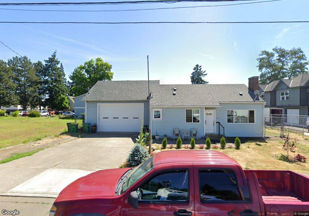
1911 Hawthorne St Forest Grove, OR 97116
Estimated Value: $294,000 - $379,000
2
Beds
1
Bath
798
Sq Ft
$434/Sq Ft
Est. Value
About This Home
This home is located at 1911 Hawthorne St, Forest Grove, OR 97116 and is currently estimated at $346,028, approximately $433 per square foot. 1911 Hawthorne St is a home located in Washington County with nearby schools including Joseph Gale Elementary School, Tom McCall Upper Elementary School, and Neil Armstrong Middle School.
Ownership History
Date
Name
Owned For
Owner Type
Purchase Details
Closed on
Apr 14, 2023
Sold by
Julia Ellis Living Trust
Bought by
Dilorenzo Anthony Pasquale
Current Estimated Value
Home Financials for this Owner
Home Financials are based on the most recent Mortgage that was taken out on this home.
Original Mortgage
$304,000
Outstanding Balance
$294,917
Interest Rate
6.6%
Mortgage Type
New Conventional
Estimated Equity
$51,111
Purchase Details
Closed on
Mar 7, 2022
Sold by
Ellis Julia A
Bought by
Julia Ellis Living Trust
Create a Home Valuation Report for This Property
The Home Valuation Report is an in-depth analysis detailing your home's value as well as a comparison with similar homes in the area
Home Values in the Area
Average Home Value in this Area
Purchase History
| Date | Buyer | Sale Price | Title Company |
|---|---|---|---|
| Dilorenzo Anthony Pasquale | $320,000 | First American Title | |
| Julia Ellis Living Trust | -- | None Listed On Document |
Source: Public Records
Mortgage History
| Date | Status | Borrower | Loan Amount |
|---|---|---|---|
| Open | Dilorenzo Anthony Pasquale | $304,000 |
Source: Public Records
Tax History Compared to Growth
Tax History
| Year | Tax Paid | Tax Assessment Tax Assessment Total Assessment is a certain percentage of the fair market value that is determined by local assessors to be the total taxable value of land and additions on the property. | Land | Improvement |
|---|---|---|---|---|
| 2026 | $1,438 | $80,750 | -- | -- |
| 2025 | $1,438 | $78,400 | -- | -- |
| 2024 | $1,387 | $76,120 | -- | -- |
| 2023 | $1,387 | $73,910 | $0 | $0 |
| 2022 | $1,213 | $73,910 | $0 | $0 |
| 2021 | $1,197 | $69,670 | $0 | $0 |
| 2020 | $1,191 | $67,650 | $0 | $0 |
| 2019 | $1,165 | $65,680 | $0 | $0 |
| 2018 | $1,129 | $63,770 | $0 | $0 |
| 2017 | $1,094 | $61,920 | $0 | $0 |
| 2016 | $1,063 | $60,120 | $0 | $0 |
| 2015 | $1,022 | $58,370 | $0 | $0 |
| 2014 | $1,018 | $56,670 | $0 | $0 |
Source: Public Records
Map
Nearby Homes
- 1822 Hawthorne St
- 1813 Filbert St
- 2824 19th Ave
- 2815 18th Ave
- 2902 19th Ave
- 2828 22nd Ave Unit 3
- 2828 22nd Ave Unit 5
- 2323 19th Ave
- 0 Kingwood St
- 2743 15th Place
- 1615 Kingwood St
- 2366 Kingwood St
- 0 Crescent Dr
- 2321 Annie Lou Ct
- 2820 23rd Place
- 2220 17th Ave
- 3128 Brittany Dr
- 2358 Kingwood St
- 3213 Maple Place
- 3404 19th Ave Unit 103
- 1903 Hawthorne St Unit A
- 1903 Hawthorne St
- 2717 19th Ave
- 2716 19th Ave
- 2716 19th Place
- 0 Hawthorne St
- 2639 19th Ave
- 1914 Hawthorne St
- 2633 19th Ave
- 1918 Hawthorne St
- 1924 Hawthorne St
- 2722 19th Place
- 1928 Hawthorne St
- 2627 19th Ave
- 2728 19th Place
- 2720 19th Ave
- 2621 19th Ave
- 2737 19th Ave
- 2738 19th Place
- 1825 Hawthorne St Unit 2