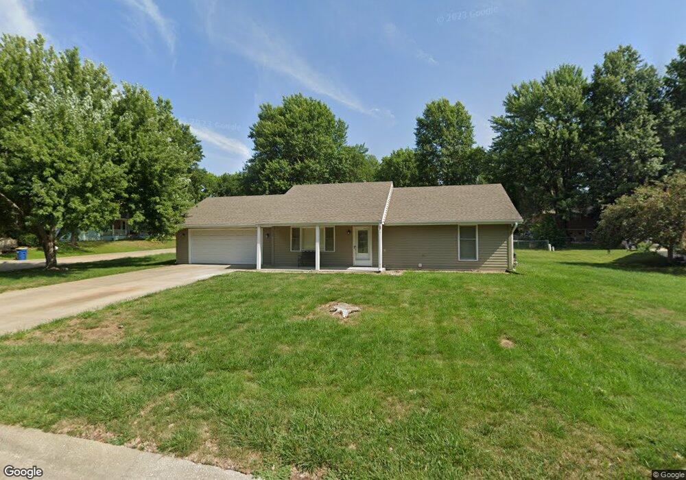
1911 Joy St Excelsior Springs, MO 64024
Estimated Value: $232,644 - $256,000
2
Beds
1
Bath
1,040
Sq Ft
$236/Sq Ft
Est. Value
About This Home
This home is located at 1911 Joy St, Excelsior Springs, MO 64024 and is currently estimated at $245,411, approximately $235 per square foot. 1911 Joy St is a home located in Clay County with nearby schools including Excelsior Springs High School.
Ownership History
Date
Name
Owned For
Owner Type
Purchase Details
Closed on
Sep 29, 2003
Sold by
Mcelwee James Brent
Bought by
Andersen Timothy M
Current Estimated Value
Home Financials for this Owner
Home Financials are based on the most recent Mortgage that was taken out on this home.
Original Mortgage
$106,000
Outstanding Balance
$49,568
Interest Rate
6.24%
Mortgage Type
Purchase Money Mortgage
Estimated Equity
$195,843
Purchase Details
Closed on
Apr 30, 2003
Sold by
Schneider Clarence and Schneider Vicki
Bought by
Mcelwee James Brent
Purchase Details
Closed on
Apr 25, 2000
Sold by
Heman Mary K
Bought by
Schneider Clarence and Schneider Vickie
Home Financials for this Owner
Home Financials are based on the most recent Mortgage that was taken out on this home.
Original Mortgage
$20,000
Interest Rate
6.75%
Create a Home Valuation Report for This Property
The Home Valuation Report is an in-depth analysis detailing your home's value as well as a comparison with similar homes in the area
Home Values in the Area
Average Home Value in this Area
Purchase History
| Date | Buyer | Sale Price | Title Company |
|---|---|---|---|
| Andersen Timothy M | -- | First American Title Ins Co | |
| Mcelwee James Brent | -- | First American Title Ins Co | |
| Schneider Clarence | $81,500 | Excelsior Abstract & Title C |
Source: Public Records
Mortgage History
| Date | Status | Borrower | Loan Amount |
|---|---|---|---|
| Open | Andersen Timothy M | $106,000 | |
| Previous Owner | Schneider Clarence | $20,000 |
Source: Public Records
Tax History Compared to Growth
Tax History
| Year | Tax Paid | Tax Assessment Tax Assessment Total Assessment is a certain percentage of the fair market value that is determined by local assessors to be the total taxable value of land and additions on the property. | Land | Improvement |
|---|---|---|---|---|
| 2025 | $2,052 | $32,280 | -- | -- |
| 2024 | $2,052 | $29,260 | -- | -- |
| 2023 | $2,039 | $29,260 | $0 | $0 |
| 2022 | $1,781 | $25,140 | $0 | $0 |
| 2021 | $1,788 | $25,137 | $3,800 | $21,337 |
| 2020 | $1,610 | $22,000 | $0 | $0 |
| 2019 | $1,609 | $22,000 | $0 | $0 |
| 2018 | $1,565 | $21,340 | $0 | $0 |
| 2017 | $1,526 | $21,340 | $3,420 | $17,920 |
| 2016 | $1,526 | $21,340 | $3,420 | $17,920 |
| 2015 | $1,540 | $21,340 | $3,420 | $17,920 |
| 2014 | $1,510 | $20,730 | $3,420 | $17,310 |
Source: Public Records
Map
Nearby Homes
- 2006 E Norma Ct
- 1724 Aspen Ln
- 0 Meadowlark Ln
- 211 Carla St
- 1018 Miss Belle St
- 1017 Rose Ave
- 1009 Miss Belle St
- 112 Delores St
- 822 Dogwood St
- 1223 Milwaukee St
- 1216 Michele Dr
- 316 May St
- 1318 Kristie Cir
- 328 Virginia Rd
- 119 May St
- 110 Ridgeway St
- 116 Greenwood Ave
- 214 Oakwood Ave
- 941 N Jesse James Rd
- 1104 Frontier St