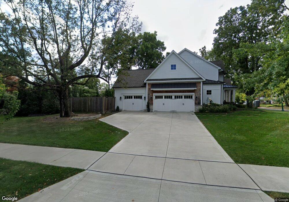
1911 Waltham Rd Columbus, OH 43221
Estimated Value: $1,196,000 - $1,958,942
3
Beds
3
Baths
3,256
Sq Ft
$482/Sq Ft
Est. Value
About This Home
This home is located at 1911 Waltham Rd, Columbus, OH 43221 and is currently estimated at $1,569,236, approximately $481 per square foot. 1911 Waltham Rd is a home located in Franklin County with nearby schools including Barrington Road Elementary School, Jones Middle School, and Upper Arlington High School.
Ownership History
Date
Name
Owned For
Owner Type
Purchase Details
Closed on
Jun 6, 2025
Sold by
Nabavi Family Trust and Nabavi Cameron B
Bought by
Jack Straw Llc
Current Estimated Value
Purchase Details
Closed on
Nov 7, 2022
Sold by
Nabavi Cameron B and Nabavi Carma L
Bought by
Nabavi Family Trust
Purchase Details
Closed on
May 8, 2019
Sold by
Compass Homes Inc
Bought by
Nabavi Cameron B and Nabavi Carma L
Purchase Details
Closed on
May 6, 2019
Sold by
Shores Ellen and Shores Craig
Bought by
Compass Homes Inc
Purchase Details
Closed on
Dec 17, 2017
Sold by
Mabo Llc
Bought by
Shores Craig and Shores Ellen
Purchase Details
Closed on
Dec 14, 2017
Sold by
Shamrock Trinity Llc
Bought by
Shores Craig and Shores Ellen
Purchase Details
Closed on
Sep 28, 2017
Sold by
Dunagan Christina J
Bought by
Obam Real Estate Holdings Llc and Mabo Llc
Purchase Details
Closed on
Nov 20, 2006
Sold by
Dunagan Christopher L
Bought by
Dunagan Christina T
Purchase Details
Closed on
Sep 23, 2002
Sold by
Bahrami Sadegh
Bought by
Dunagan Christopher L and Dunagan Christine J
Home Financials for this Owner
Home Financials are based on the most recent Mortgage that was taken out on this home.
Original Mortgage
$224,000
Interest Rate
6.39%
Mortgage Type
Purchase Money Mortgage
Purchase Details
Closed on
Aug 30, 1994
Sold by
James Nancy A
Bought by
Driscoll William P and Driscoll Marsha B
Home Financials for this Owner
Home Financials are based on the most recent Mortgage that was taken out on this home.
Original Mortgage
$150,000
Interest Rate
8.72%
Mortgage Type
New Conventional
Purchase Details
Closed on
Aug 30, 1989
Create a Home Valuation Report for This Property
The Home Valuation Report is an in-depth analysis detailing your home's value as well as a comparison with similar homes in the area
Home Values in the Area
Average Home Value in this Area
Purchase History
| Date | Buyer | Sale Price | Title Company |
|---|---|---|---|
| Jack Straw Llc | -- | Peak Title | |
| Nabavi Family Trust | -- | Peak Title | |
| Nabavi Cameron B | $400,000 | Stewart Title Box | |
| Compass Homes Inc | -- | Stewart Title Box | |
| Shores Craig | $150,000 | None Available | |
| Shores Craig | $150,000 | None Available | |
| Obam Real Estate Holdings Llc | $408,000 | None Available | |
| Dunagan Christina T | $280,000 | None Available | |
| Dunagan Christopher L | $280,000 | Chicago Title | |
| Driscoll William P | $214,500 | -- | |
| -- | -- | -- |
Source: Public Records
Mortgage History
| Date | Status | Borrower | Loan Amount |
|---|---|---|---|
| Previous Owner | Dunagan Christopher L | $224,000 | |
| Previous Owner | Driscoll William P | $150,000 |
Source: Public Records
Tax History Compared to Growth
Tax History
| Year | Tax Paid | Tax Assessment Tax Assessment Total Assessment is a certain percentage of the fair market value that is determined by local assessors to be the total taxable value of land and additions on the property. | Land | Improvement |
|---|---|---|---|---|
| 2024 | $29,003 | $500,650 | $141,930 | $358,720 |
| 2023 | $28,625 | $500,640 | $141,925 | $358,715 |
| 2022 | $26,104 | $373,560 | $118,790 | $254,770 |
| 2021 | $23,258 | $366,030 | $118,790 | $247,240 |
| 2020 | $11,853 | $190,580 | $88,170 | $102,410 |
| 2019 | $6,369 | $91,850 | $88,170 | $3,680 |
| 2018 | $9,204 | $108,260 | $88,170 | $20,090 |
| 2017 | $13,559 | $188,130 | $118,790 | $69,340 |
| 2016 | $8,256 | $122,400 | $97,930 | $24,470 |
| 2015 | $7,292 | $107,420 | $97,930 | $9,490 |
| 2014 | $7,104 | $107,420 | $97,930 | $9,490 |
| 2013 | $3,461 | $97,650 | $89,040 | $8,610 |
Source: Public Records
Map
Nearby Homes
- 2110 Northwest Blvd
- 1869 Tewksbury Rd
- 1782 Wyandotte Rd
- 2063 Westover Rd
- 1914 Elmwood Ave
- 1733 Elmwood Ave
- 1535 Doone Rd
- 2015 W 5th Ave Unit 211
- 2015 W 5th Ave Unit 102
- 2015 W 5th Ave Unit 108
- 1631 Roxbury Rd Unit F3
- 1631 Roxbury Rd Unit B6
- 1565 Berkshire Rd
- 1661 Ashland Ave Unit 663
- 1561 Glenn Ave
- 1398 Lower Green Cir Unit 1398
- 2583 Wexford Rd
- 1459 Elmwood Ave Unit 1459
- 2170 Lane Woods Dr Unit 2170
- 1364 W 7th Ave
- 2034 N Devon Rd
- 0 Waltham Rd
- 2053 Waltham Rd
- 2053 Coventry Rd
- 2039 Coventry Rd
- 2022 N Devon Rd
- 2043 N Devon Rd
- 2031 N Devon Rd
- 2027 Coventry Rd
- 2016 N Devon Rd
- 2021 N Devon Rd
- 2019 Coventry Rd
- 2050 Coventry Rd
- 1945 Waltham Rd
- 2022 Arlington Ave
- 2036 Coventry Rd
- 1892 Edgemont Rd
- 2078 Coventry Rd
- 2084 Coventry Rd
- 2012 Arlington Ave