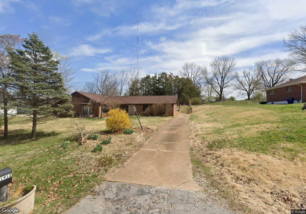
1912 Burnett Ave Saint Louis, MO 63125
Lemay NeighborhoodEstimated Value: $266,000 - $311,000
3
Beds
1
Bath
2,337
Sq Ft
$120/Sq Ft
Est. Value
About This Home
This home is located at 1912 Burnett Ave, Saint Louis, MO 63125 and is currently estimated at $279,418, approximately $119 per square foot. 1912 Burnett Ave is a home located in St. Louis County with nearby schools including Bierbaum Elementary School, Margaret Buerkle Middle School, and Mehlville High School.
Ownership History
Date
Name
Owned For
Owner Type
Purchase Details
Closed on
Oct 31, 2020
Sold by
Coats James and Coats Casey
Bought by
Coats Casey
Current Estimated Value
Purchase Details
Closed on
Sep 20, 2002
Sold by
Ottoline Terrence G and Ottoline Terrance G
Bought by
Coats James M and Coats Casey E
Home Financials for this Owner
Home Financials are based on the most recent Mortgage that was taken out on this home.
Original Mortgage
$159,032
Outstanding Balance
$66,288
Interest Rate
6.21%
Mortgage Type
VA
Estimated Equity
$213,130
Create a Home Valuation Report for This Property
The Home Valuation Report is an in-depth analysis detailing your home's value as well as a comparison with similar homes in the area
Home Values in the Area
Average Home Value in this Area
Purchase History
| Date | Buyer | Sale Price | Title Company |
|---|---|---|---|
| Coats Casey | -- | None Available | |
| Coats James M | $154,400 | -- |
Source: Public Records
Mortgage History
| Date | Status | Borrower | Loan Amount |
|---|---|---|---|
| Open | Coats James M | $159,032 |
Source: Public Records
Tax History Compared to Growth
Tax History
| Year | Tax Paid | Tax Assessment Tax Assessment Total Assessment is a certain percentage of the fair market value that is determined by local assessors to be the total taxable value of land and additions on the property. | Land | Improvement |
|---|---|---|---|---|
| 2025 | $2,311 | $31,350 | $19,250 | $12,100 |
| 2024 | $2,311 | $31,350 | $11,970 | $19,380 |
| 2023 | $2,178 | $31,350 | $11,970 | $19,380 |
| 2022 | $2,742 | $36,680 | $12,830 | $23,850 |
| 2021 | $2,517 | $36,680 | $12,830 | $23,850 |
| 2020 | $2,071 | $28,500 | $14,060 | $14,440 |
| 2019 | $2,066 | $28,500 | $14,060 | $14,440 |
| 2018 | $2,004 | $24,610 | $7,510 | $17,100 |
| 2017 | $1,999 | $24,610 | $7,510 | $17,100 |
| 2016 | $1,676 | $19,750 | $5,990 | $13,760 |
| 2015 | $1,580 | $19,750 | $5,990 | $13,760 |
| 2014 | $2,042 | $25,520 | $4,470 | $21,050 |
Source: Public Records
Map
Nearby Homes
- 1905 Mansard Dr Unit 1905
- 4203 Lions Chase Dr
- 4127 Burnett Ave
- 1871 Mansard Dr Unit 1917
- 4259 Burnett Walk Unit 4259
- 1918 Union Rd
- 1908 Union Rd Unit 1908
- 2245 Pecan Dr
- 2324 Birch Dr
- 9920 Bunker Hill Dr Unit E
- 2215 Apple Bud Ln
- 2337 Birch Dr
- 9030 Villaridge Ct Unit 53
- 2216 Apple Bud Ln
- 10010 Bunker Hill Dr Unit H
- 10018 Bunker Hill Dr Unit G
- 9883 Ione Ln
- 3809 Tahquitz Dr
- 9197 Villaridge Ct
- 9070 Villaridge Ct Unit 38
- 1926 Burnett Ave
- 1927 Simba Cir
- 4101 Burnett Ave
- 1930 Burnett Ave
- 4112 Burnett Ave
- 1915 Burnett Ave
- 4105 Burnett Ave
- 1919 Burnett Ave
- 1925 Burnett Ave
- 1924 Simba Cir
- 4013 Reavis Barracks Rd
- 1911 Simba Cir
- 1920 Simba Cir
- 4115 Burnett Ave
- 4009 Reavis Barracks Rd
- 4118 Burnett Ave
- 4017 Reavis Barracks Rd
- 4025 Reavis Barracks Rd
- 2 Ashford at Lion's Chase
- 2BBLT Ashford at Riverstone