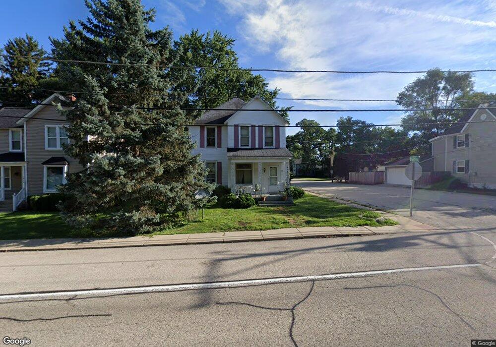
1912 Main Street Rd Spring Grove, IL 60081
Estimated Value: $216,167 - $349,000
--
Bed
--
Bath
--
Sq Ft
4,443
Sq Ft Lot
About This Home
This home is located at 1912 Main Street Rd, Spring Grove, IL 60081 and is currently estimated at $280,792. 1912 Main Street Rd is a home located in McHenry County with nearby schools including Spring Grove Elementary School, Nippersink Middle School, and Richmond-Burton High School.
Ownership History
Date
Name
Owned For
Owner Type
Purchase Details
Closed on
Mar 6, 2013
Sold by
Huff Lewis and Huff Debra L
Bought by
Huff Lewis
Current Estimated Value
Home Financials for this Owner
Home Financials are based on the most recent Mortgage that was taken out on this home.
Original Mortgage
$71,300
Outstanding Balance
$51,900
Interest Rate
4.25%
Mortgage Type
New Conventional
Estimated Equity
$228,892
Purchase Details
Closed on
Nov 30, 1998
Sold by
Abrahams Glen D
Bought by
Huff Lewis and Huff Debra L
Home Financials for this Owner
Home Financials are based on the most recent Mortgage that was taken out on this home.
Original Mortgage
$80,000
Interest Rate
10.25%
Create a Home Valuation Report for This Property
The Home Valuation Report is an in-depth analysis detailing your home's value as well as a comparison with similar homes in the area
Home Values in the Area
Average Home Value in this Area
Purchase History
| Date | Buyer | Sale Price | Title Company |
|---|---|---|---|
| Huff Lewis | -- | None Available | |
| Huff Lewis | -- | -- |
Source: Public Records
Mortgage History
| Date | Status | Borrower | Loan Amount |
|---|---|---|---|
| Open | Huff Lewis | $71,300 | |
| Closed | Huff Lewis | $80,000 |
Source: Public Records
Tax History Compared to Growth
Tax History
| Year | Tax Paid | Tax Assessment Tax Assessment Total Assessment is a certain percentage of the fair market value that is determined by local assessors to be the total taxable value of land and additions on the property. | Land | Improvement |
|---|---|---|---|---|
| 2024 | $3,920 | $60,192 | $4,901 | $55,291 |
| 2023 | $3,869 | $56,139 | $4,571 | $51,568 |
| 2022 | $3,694 | $49,383 | $4,021 | $45,362 |
| 2021 | $3,493 | $46,553 | $3,791 | $42,762 |
| 2020 | $3,401 | $44,502 | $3,624 | $40,878 |
| 2019 | $3,418 | $43,810 | $3,568 | $40,242 |
| 2018 | $3,477 | $42,456 | $3,458 | $38,998 |
| 2017 | $3,407 | $39,868 | $3,247 | $36,621 |
| 2016 | $3,403 | $38,075 | $3,101 | $34,974 |
| 2013 | -- | $40,587 | $3,305 | $37,282 |
Source: Public Records
Map
Nearby Homes
- 2214 Main Street Rd
- Lot 65 & 66 Main Street Rd
- LOT 9 Mayo Ct
- 7710 Ravina Dr
- 1992 Red Oak Ln
- 1876 Red Oak Ln
- 1996 Red Oak Ln
- Lot 64 Beverly Way
- Lot 61 Beverly Way
- Lot 60 Beverly Way
- Lot 59 Beverly Way
- Lot 58 Beverly Way
- Lot 57 Beverly Way
- LOT 56 Beverly Way
- Lot 36 Red Oak Ln
- LOT 40 Red Oak Ln
- 7397 English Oak Ln
- 1979 Red Oak Ln
- 2003 Red Oak Ln
- 7392 English Oak Ln
- 1914 Main Street Rd
- 1816 Main Street Rd
- 8013 East St
- 1918 Main Street Rd
- 8014 East St
- 1814 Main Street Rd
- 1920 Main Street Rd
- 1911 Main Street Rd
- 1922 Main Street Rd
- 1812 Main Street Rd
- 1813 Main Street Rd
- 1810 Main St Rd
- 8010 East St
- 1924 Main Street Rd
- 8010 East Ct
- 8008 East St
- 1921 Main Street Rd
- 8020 East St
- 8020 Blivin St
- 1912 North St