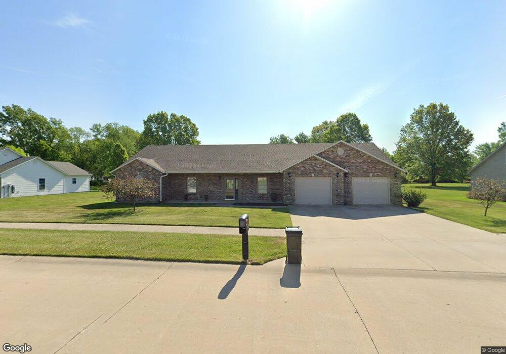
1912 Wabash Ave Moberly, MO 65270
Estimated Value: $303,000 - $361,000
4
Beds
3
Baths
2,460
Sq Ft
$134/Sq Ft
Est. Value
About This Home
This home is located at 1912 Wabash Ave, Moberly, MO 65270 and is currently estimated at $328,965, approximately $133 per square foot. 1912 Wabash Ave is a home located in Randolph County with nearby schools including Moberly Senior High School, Maranatha Seventh-day Adventist School, and Terrill Road Christian Academy.
Ownership History
Date
Name
Owned For
Owner Type
Purchase Details
Closed on
Mar 13, 2009
Sold by
Weis John
Bought by
John Weis Revocable Trust
Current Estimated Value
Purchase Details
Closed on
Sep 23, 2008
Sold by
Pollard Johnnie Dale and Pollard Debbie
Bought by
Weis John
Home Financials for this Owner
Home Financials are based on the most recent Mortgage that was taken out on this home.
Original Mortgage
$141,200
Interest Rate
6.46%
Create a Home Valuation Report for This Property
The Home Valuation Report is an in-depth analysis detailing your home's value as well as a comparison with similar homes in the area
Home Values in the Area
Average Home Value in this Area
Purchase History
| Date | Buyer | Sale Price | Title Company |
|---|---|---|---|
| John Weis Revocable Trust | -- | -- | |
| Weis John | -- | -- |
Source: Public Records
Mortgage History
| Date | Status | Borrower | Loan Amount |
|---|---|---|---|
| Previous Owner | Weis John | $141,200 |
Source: Public Records
Tax History Compared to Growth
Tax History
| Year | Tax Paid | Tax Assessment Tax Assessment Total Assessment is a certain percentage of the fair market value that is determined by local assessors to be the total taxable value of land and additions on the property. | Land | Improvement |
|---|---|---|---|---|
| 2025 | $2,865 | $44,189 | $3,714 | $40,475 |
| 2024 | $2,865 | $39,350 | $3,230 | $36,120 |
| 2023 | $2,909 | $39,350 | $3,230 | $36,120 |
| 2022 | $2,726 | $37,860 | $3,230 | $34,630 |
| 2021 | $2,724 | $37,860 | $3,230 | $34,630 |
| 2020 | $2,724 | $37,860 | $3,230 | $34,630 |
| 2019 | $2,719 | $37,860 | $3,230 | $34,630 |
| 2018 | $2,719 | $37,990 | $3,230 | $34,760 |
| 2017 | $2,714 | $37,990 | $0 | $0 |
| 2016 | $2,548 | $35,860 | $0 | $0 |
| 2014 | -- | $33,660 | $0 | $0 |
| 2013 | -- | $33,660 | $0 | $0 |
| 2012 | -- | $33,630 | $0 | $0 |
Source: Public Records
Map
Nearby Homes
- 1826 S Morley St
- 1825 S Morley St
- 315 W Urbandale Dr
- 501 Terrill Rd
- 2010 Sterling Dr
- 1365 Lantern Pointe Dr
- 0 S Ridge Subdivision Unit 413910
- 0 S Ridge Subdivision Unit 413909
- 0 S Ridge Subdivision Unit 413908
- 0 S Ridge Subdivision Unit 413906
- 0 S Ridge Subdivision Unit 18-418
- 0 S Ridge Subdivision Unit 18-417
- 0 S Ridge Subdivision Unit 18-416
- 0 S Ridge Subdivision Unit 22-6
- 900 Destinee Dr
- 913 Destinee Dr
- 2105 Vinny Ave
- 2108 Vinny Ave
- 2109 Vinny Ave
- 2122 Vinny Ave
- 1910 Wabash Ave
- 1911 Wabash Ave
- 1908 Wabash Ave
- 1913 Wabash Ave
- 2000 Wabash Ave
- 2001 Wabash Ave
- 1909 Wabash Ave
- 335 Morningside Dr
- 2003 Wabash Ave
- 1906 Wabash Ave
- 1907 Wabash Ave
- 2002 Wabash Ave
- 1910 Chariton Ave
- 325 Morningside Dr
- 1912 Chariton Ave
- 314 Morningside Dr
- 1908 Chariton Ave
- 2005 Wabash Ave
- 2004 Wabash Ave
- 1905 Wabash Ave