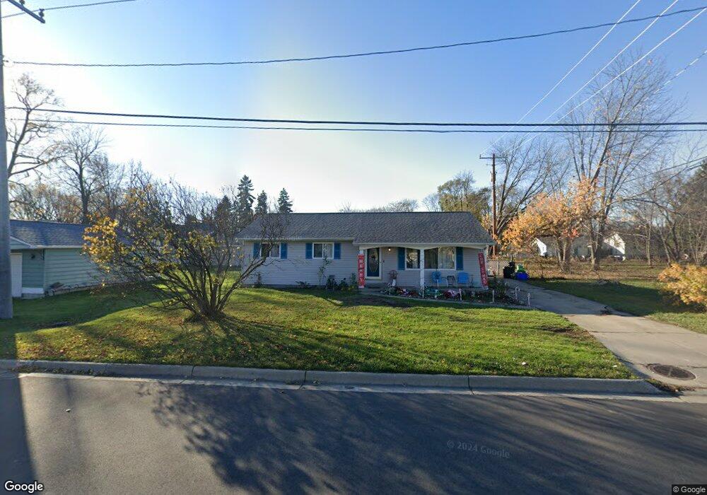
1913 12th Ave Port Huron, MI 48060
Estimated Value: $175,000 - $203,326
3
Beds
2
Baths
1,232
Sq Ft
$154/Sq Ft
Est. Value
About This Home
This home is located at 1913 12th Ave, Port Huron, MI 48060 and is currently estimated at $189,582, approximately $153 per square foot. 1913 12th Ave is a home located in St. Clair County with nearby schools including H.D. Crull Elementary School, Holland Woods Middle School, and Port Huron Northern High School.
Ownership History
Date
Name
Owned For
Owner Type
Purchase Details
Closed on
Sep 16, 2011
Sold by
Federal Home Loan Mortgage Corporation
Bought by
Pawiak Matthew
Current Estimated Value
Purchase Details
Closed on
Mar 3, 2011
Sold by
White James W and White Laura L
Bought by
Federal Home Loan Mortgage Corp
Purchase Details
Closed on
Mar 11, 2010
Sold by
White Revocable Trust
Bought by
White James M and White Laura L
Purchase Details
Closed on
Nov 21, 2006
Sold by
White James M and White Laura L
Bought by
White James W and White Laura L
Create a Home Valuation Report for This Property
The Home Valuation Report is an in-depth analysis detailing your home's value as well as a comparison with similar homes in the area
Home Values in the Area
Average Home Value in this Area
Purchase History
| Date | Buyer | Sale Price | Title Company |
|---|---|---|---|
| Pawiak Matthew | $51,000 | Attorneys Title Agency Llc | |
| Federal Home Loan Mortgage Corp | $27,900 | None Available | |
| White James M | -- | None Available | |
| White James W | -- | None Available |
Source: Public Records
Tax History Compared to Growth
Tax History
| Year | Tax Paid | Tax Assessment Tax Assessment Total Assessment is a certain percentage of the fair market value that is determined by local assessors to be the total taxable value of land and additions on the property. | Land | Improvement |
|---|---|---|---|---|
| 2025 | $2,030 | $89,300 | $0 | $0 |
| 2024 | $1,716 | $84,300 | $0 | $0 |
| 2023 | $1,621 | $75,200 | $0 | $0 |
| 2022 | $1,689 | $64,600 | $0 | $0 |
| 2021 | $1,604 | $60,500 | $0 | $0 |
| 2020 | $1,622 | $56,500 | $56,500 | $0 |
| 2019 | $1,593 | $39,200 | $0 | $0 |
| 2018 | $1,558 | $39,200 | $0 | $0 |
| 2017 | $1,391 | $36,800 | $0 | $0 |
| 2016 | $1,187 | $36,800 | $0 | $0 |
| 2015 | $1,165 | $33,600 | $33,600 | $0 |
| 2014 | $1,165 | $32,500 | $32,500 | $0 |
| 2013 | -- | $32,600 | $0 | $0 |
Source: Public Records
Map
Nearby Homes
- 1620 McBrady St
- 1632 McBrady St
- 1802 Riverside Dr
- 1649 Whipple St
- 1691 McBrady St
- 1907 Riverside Dr
- 1819 Riverside Dr
- 1523 11th Ave
- 1503 Elk St
- 1704 Edison Shores Ln Unit 52
- 1004 State St
- 2400 Stone St Unit 2414
- 1027 Elmwood St
- 2311 Elmwood St
- 2609 15th Ave
- 1303 10th Ave
- 2401 Walnut St
- 2428 20th Ave
- 1307 Hancock St
- 2400 Walnut St