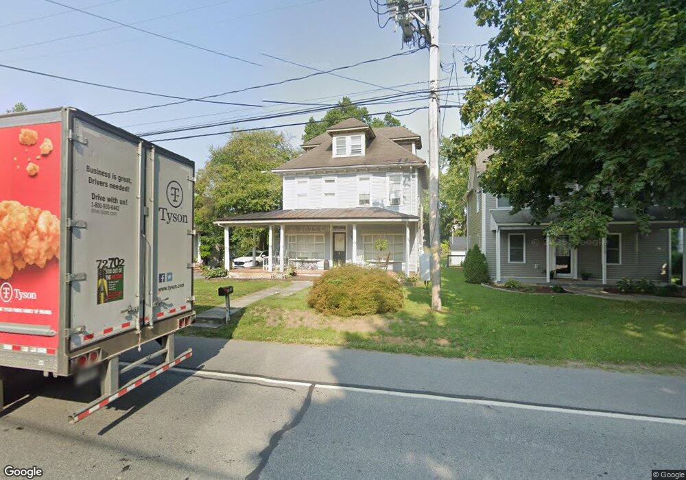
1913 New Holland Pike Lancaster, PA 17601
Eden NeighborhoodEstimated Value: $316,000 - $439,000
3
Beds
2
Baths
1,736
Sq Ft
$208/Sq Ft
Est. Value
About This Home
This home is located at 1913 New Holland Pike, Lancaster, PA 17601 and is currently estimated at $360,687, approximately $207 per square foot. 1913 New Holland Pike is a home located in Lancaster County with nearby schools including Nitrauer School, Landis Run Intermediate School, and Manheim Township Middle School.
Ownership History
Date
Name
Owned For
Owner Type
Purchase Details
Closed on
Feb 17, 2011
Sold by
Us Bank National Association
Bought by
Lehman Gregory L
Current Estimated Value
Home Financials for this Owner
Home Financials are based on the most recent Mortgage that was taken out on this home.
Original Mortgage
$112,084
Interest Rate
5.5%
Mortgage Type
FHA
Purchase Details
Closed on
Nov 24, 2010
Sold by
Hecker James T
Bought by
Us Bank National Association
Purchase Details
Closed on
Jun 27, 2009
Sold by
Hecker James T and Turk Michele
Bought by
Hecker James T
Purchase Details
Closed on
Aug 25, 2006
Sold by
Frank Jonathan D and Frank Lisa L
Bought by
Hecker James T and Turk Michele
Home Financials for this Owner
Home Financials are based on the most recent Mortgage that was taken out on this home.
Original Mortgage
$148,800
Interest Rate
7.7%
Mortgage Type
Purchase Money Mortgage
Create a Home Valuation Report for This Property
The Home Valuation Report is an in-depth analysis detailing your home's value as well as a comparison with similar homes in the area
Home Values in the Area
Average Home Value in this Area
Purchase History
| Date | Buyer | Sale Price | Title Company |
|---|---|---|---|
| Lehman Gregory L | $115,000 | None Available | |
| Us Bank National Association | $4,963 | None Available | |
| Hecker James T | -- | None Available | |
| Hecker James T | $186,000 | None Available |
Source: Public Records
Mortgage History
| Date | Status | Borrower | Loan Amount |
|---|---|---|---|
| Previous Owner | Lehman Gregory L | $112,084 | |
| Previous Owner | Hecker James T | $148,800 |
Source: Public Records
Tax History Compared to Growth
Tax History
| Year | Tax Paid | Tax Assessment Tax Assessment Total Assessment is a certain percentage of the fair market value that is determined by local assessors to be the total taxable value of land and additions on the property. | Land | Improvement |
|---|---|---|---|---|
| 2025 | $3,542 | $163,700 | $57,000 | $106,700 |
| 2024 | $3,542 | $163,700 | $57,000 | $106,700 |
| 2023 | $3,450 | $163,700 | $57,000 | $106,700 |
| 2022 | $3,392 | $163,700 | $57,000 | $106,700 |
| 2021 | $3,316 | $163,700 | $57,000 | $106,700 |
| 2020 | $3,316 | $163,700 | $57,000 | $106,700 |
| 2019 | $3,284 | $163,700 | $57,000 | $106,700 |
| 2018 | $2,366 | $163,700 | $57,000 | $106,700 |
| 2017 | $3,919 | $154,000 | $46,700 | $107,300 |
| 2016 | $3,919 | $154,000 | $46,700 | $107,300 |
| 2015 | $985 | $154,000 | $46,700 | $107,300 |
| 2014 | $2,763 | $154,000 | $46,700 | $107,300 |
Source: Public Records
Map
Nearby Homes
- 1935 New Holland Pike
- 1919 Pickering Trail
- 1915 Pickering Trail
- 1923 Pickering Trail
- 1914 Pickering Trail
- 1922 Pickering Trail
- 1981 Landis Valley Rd
- 2010 Landis Valley Rd
- 2111 Landis Valley Rd
- 1550 Euclid Dr
- 2007 Meadow Ridge Dr
- 2043 Stonecrest Dr
- 0 Butter Rd
- 0 Butter Rd
- 1150 Groff Ln
- 2098 Mallard Dr
- 212 Greenview Dr Unit T2212
- 672 Stockdale Dr
- 575 Millcross Rd
- 200 Hershey Ln Unit CRESTWOOD
- 1909 New Holland Pike
- 1921 New Holland Pike
- 1925 New Holland Pike
- 1901 New Holland Pike
- 1916 New Holland Pike
- 1929 New Holland Pike
- 1884 New Holland Pike
- 1939 New Holland Pike
- 1878 New Holland Pike
- 1919 Pickering Trail Unit 6
- 1915 Pickering Trail Unit 3
- 1870 New Holland Pike
- 1923 Pickering Trail Unit 7
- 1953 New Holland Pike
- 1931 Glendower Dr
- 1859 New Holland Pike
- 1947 New Holland Pike
- 1914 Pickering Trail Unit 4
- 1961 New Holland Pike
- 1927 Glendower Dr