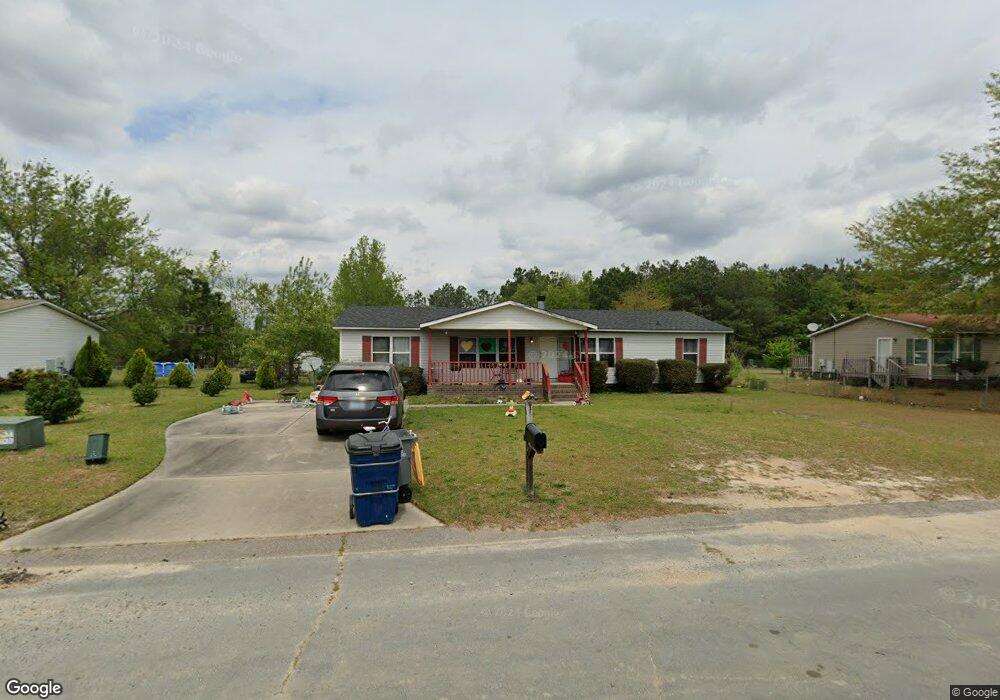
1914 Mcgregor Dr Raeford, NC 28376
Estimated Value: $49,188 - $159,000
3
Beds
2
Baths
1,512
Sq Ft
$72/Sq Ft
Est. Value
About This Home
This home is located at 1914 Mcgregor Dr, Raeford, NC 28376 and is currently estimated at $108,797, approximately $71 per square foot. 1914 Mcgregor Dr is a home located in Hoke County with nearby schools including Upchurch Elementary School, East Hoke Middle, and Hoke County High.
Ownership History
Date
Name
Owned For
Owner Type
Purchase Details
Closed on
Sep 27, 2024
Sold by
Marzolf Bryan Mathew and Marzolf Jaylaan
Bought by
Call William C and Call Noemi
Current Estimated Value
Purchase Details
Closed on
Apr 11, 2017
Sold by
Hester Tisa and Hester Steven
Bought by
Marzolf Bryan Mathew
Home Financials for this Owner
Home Financials are based on the most recent Mortgage that was taken out on this home.
Original Mortgage
$56,000
Interest Rate
4.3%
Create a Home Valuation Report for This Property
The Home Valuation Report is an in-depth analysis detailing your home's value as well as a comparison with similar homes in the area
Home Values in the Area
Average Home Value in this Area
Purchase History
| Date | Buyer | Sale Price | Title Company |
|---|---|---|---|
| Call William C | $48,000 | None Listed On Document | |
| Marzolf Bryan Mathew | $56,000 | None Available |
Source: Public Records
Mortgage History
| Date | Status | Borrower | Loan Amount |
|---|---|---|---|
| Previous Owner | Marzolf Bryan Mathew | $56,000 |
Source: Public Records
Tax History
| Year | Tax Paid | Tax Assessment Tax Assessment Total Assessment is a certain percentage of the fair market value that is determined by local assessors to be the total taxable value of land and additions on the property. | Land | Improvement |
|---|---|---|---|---|
| 2025 | $665 | $66,050 | $20,000 | $46,050 |
| 2024 | $665 | $66,050 | $20,000 | $46,050 |
| 2023 | $665 | $66,050 | $20,000 | $46,050 |
| 2022 | $654 | $66,050 | $20,000 | $46,050 |
| 2021 | $578 | $55,130 | $10,000 | $45,130 |
| 2020 | $586 | $55,130 | $10,000 | $45,130 |
| 2019 | $586 | $55,130 | $10,000 | $45,130 |
| 2018 | $586 | $55,130 | $10,000 | $45,130 |
| 2017 | $586 | $55,130 | $10,000 | $45,130 |
| 2016 | $576 | $55,130 | $10,000 | $45,130 |
| 2015 | $576 | $55,130 | $10,000 | $45,130 |
| 2014 | $557 | $55,130 | $10,000 | $45,130 |
| 2013 | -- | $70,910 | $19,000 | $51,910 |
Source: Public Records
Map
Nearby Homes
- 1410 Darby Dr
- 520 Inverary Dr
- 2410 Ohara Dr
- 196 Independence Dr
- 204 Independence Dr
- 105 McDougald Dr
- 152 Independence Dr
- 228 Tipperary St
- 247 Cloverwood Ln
- 113 Yates Mill St
- 479 Wedgefield Dr
- 286 Peaceford Ave
- 1570 Clan Campbell Dr
- 111 Cardinal Ave
- 239 Stafford Ave
- 216 Weston Woods St
- 284 Weston Woods St
- 201 Weston Woods St
- 176 Wexford St
- 190 Cromwell Ct
- 1912 Mcgregor Dr
- 1916 Mcgregor Dr
- 1913 Mcgregor Dr
- 1910 Mcgregor Dr
- 1915 Mcgregor Dr
- 1918 Mcgregor Dr
- 1911 Mcgregor Dr
- 1917 Mcgregor Dr
- 1908 Mcgregor Dr
- 1908 Mcgregor Dr Unit na
- 1909 Mcgregor Dr
- 1920 Mcgregor Dr
- 2206 Keen Ct
- 1919 Mcgregor Dr
- 2204 Keen Ct
- 1906 Mcgregor Dr
- 2208 Keen Ct
- 2202 Keen Ct
- 2100 Obrien Dr
- 1401 Clan Campbell Dr
Your Personal Tour Guide
Ask me questions while you tour the home.