
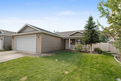
1915 N Cavalier Rd Liberty Lake, WA 99016
Greenacres NeighborhoodEstimated payment $2,483/month
Highlights
- Popular Property
- Fenced Yard
- Patio
- Cathedral Ceiling
- 2 Car Attached Garage
- 5-minute walk to Half Moon Park
About This Home
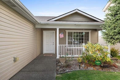
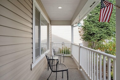
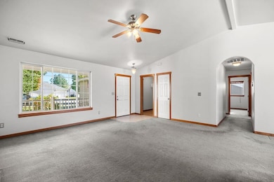
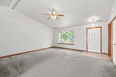
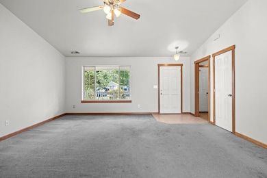
Nestled in a highly desirable neighborhood just steps from local parks, this beautifully maintained 3 bedroom, 2 bathroom home offers comfort, style, and privacy. Step inside to discover fresh interior paint, vaulted ceilings, and an abundance of natural light that fills the open living spaces. The secluded backyard is perfect for relaxing or entertaining with a garden, vibrant flowers, and a cozy fire pit area. Whether you're hosting friends or enjoying a quiet evening under the stars, this outdoor space is a great find. You will not want to miss this move in ready gem in a peaceful, park rich setting! Plus conveniently located near schools and shopping. Schedule your showing today!
Listing Agent
Keller Williams Spokane - Main Brokerage Phone: 509-309-6091 License #140044 Listed on: 10/16/2025

Home Details
Home Type
- Single Family
Est. Annual Taxes
- $3,671
Year Built
- Built in 2005
Lot Details
- 6,493 Sq Ft Lot
- Fenced Yard
- Level Lot
- Partial Sprinkler System
- Garden
HOA Fees
- $38 Monthly HOA Fees
Parking
- 2 Car Attached Garage
- Garage Door Opener
Home Design
- Slab Foundation
- Vinyl Siding
Interior Spaces
- 1,244 Sq Ft Home
- 1-Story Property
- Cathedral Ceiling
- Vinyl Clad Windows
- Utility Room
Kitchen
- Free-Standing Range
- Microwave
- Dishwasher
- Disposal
Bedrooms and Bathrooms
- 3 Bedrooms
- 2 Bathrooms
Outdoor Features
- Patio
Schools
- Selkirk Middle School
- Ridgeline High School
Utilities
- Forced Air Heating System
- High Speed Internet
Community Details
- River Crossing Subdivision
- Planned Unit Development
Listing and Financial Details
- Assessor Parcel Number 55084.1707
Map
Home Values in the Area
Average Home Value in this Area
Tax History
| Year | Tax Paid | Tax Assessment Tax Assessment Total Assessment is a certain percentage of the fair market value that is determined by local assessors to be the total taxable value of land and additions on the property. | Land | Improvement |
|---|---|---|---|---|
| 2025 | $3,671 | $350,800 | $100,000 | $250,800 |
| 2024 | $3,671 | $337,900 | $95,000 | $242,900 |
| 2023 | $3,247 | $337,900 | $95,000 | $242,900 |
| 2022 | $3,182 | $330,900 | $88,000 | $242,900 |
| 2021 | $3,078 | $236,100 | $58,000 | $178,100 |
| 2020 | $2,728 | $211,300 | $56,000 | $155,300 |
| 2019 | $2,464 | $197,000 | $56,000 | $141,000 |
| 2018 | $2,720 | $182,700 | $54,000 | $128,700 |
| 2017 | $2,493 | $169,200 | $45,000 | $124,200 |
| 2016 | $2,536 | $167,600 | $45,000 | $122,600 |
| 2015 | $2,488 | $161,300 | $40,000 | $121,300 |
| 2014 | -- | $161,300 | $40,000 | $121,300 |
| 2013 | -- | $0 | $0 | $0 |
Property History
| Date | Event | Price | List to Sale | Price per Sq Ft |
|---|---|---|---|---|
| 11/22/2025 11/22/25 | Pending | -- | -- | -- |
| 11/17/2025 11/17/25 | Price Changed | $405,000 | -2.4% | $326 / Sq Ft |
| 10/16/2025 10/16/25 | For Sale | $415,000 | -- | $334 / Sq Ft |
Purchase History
| Date | Type | Sale Price | Title Company |
|---|---|---|---|
| Warranty Deed | $157,140 | First American Title Ins |
Mortgage History
| Date | Status | Loan Amount | Loan Type |
|---|---|---|---|
| Open | $152,425 | Purchase Money Mortgage |
Source: Spokane Association of REALTORS®
MLS Number: 202525568
APN: 55084.1707
Disclaimer: Certain information contained herein is derived from information provided by parties other than Homes.com. All information provided is deemed reliable, but is not guaranteed to be accurate and should be independently verified.
![]() IDX information is provided exclusively for personal, non-commercial use, and may not be used for any purpose other than to identify prospective properties consumers may be interested in purchasing.
IDX information is provided exclusively for personal, non-commercial use, and may not be used for any purpose other than to identify prospective properties consumers may be interested in purchasing.
Information is deemed reliable but not guaranteed.
- 2007 N Aladdin Rd
- 19808 E Deschutes Ave
- 19821 E Deschutes Ave
- 19511 E Shannon Ave
- 1726 N Caufield Ct
- 19322 E Flat Rock River Ln
- 1811 N Grady Ln
- 1704 N Grady Ln
- 2020 N Hodges Ln
- 19127 E Baldwin Ln
- 1415 N Caufield Ct
- 1619 N Holiday Ln
- 19810 E Snake River Ave
- 1660 N Marne Ln
- 20170 E Glenbrook Ave
- 1550 N Cirque Ln
- 20190 E Deschutes Ave
- 1853 N Salmon River Ln
- 20211 E Deschutes Ave
- 19019 E Shannon Ln