Estimated Value: $1,009,945 - $1,156,000
4
Beds
3
Baths
3,287
Sq Ft
$326/Sq Ft
Est. Value
About This Home
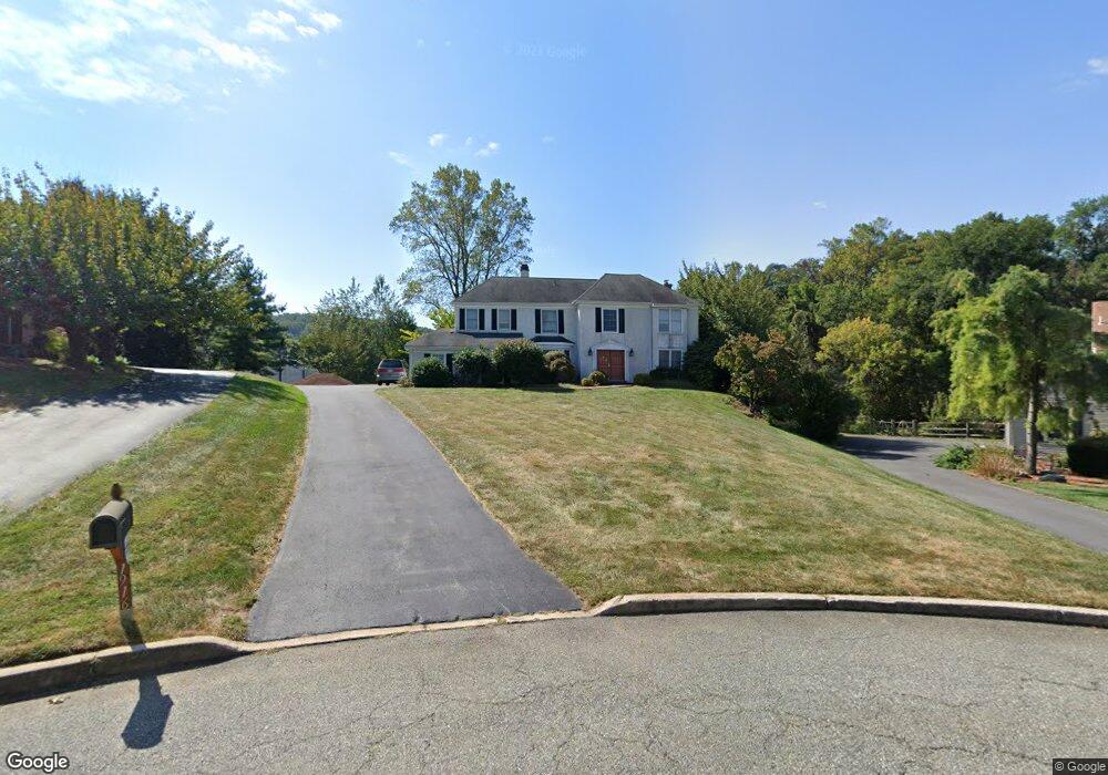
This home is located at 1916 Glenwold Dr, Paoli, PA 19301 and is currently estimated at $1,070,236, approximately $325 per square foot. 1916 Glenwold Dr is a home located in Chester County with nearby schools including Hillside Elementary School, Valley Forge Middle School, and Conestoga Senior High School.
Ownership History
Date
Name
Owned For
Owner Type
Purchase Details
Closed on
Jun 12, 1998
Sold by
Erickson Eric J and Erickson Olivia P
Bought by
Gavigan Margaret and Isenman Barry
Current Estimated Value
Home Financials for this Owner
Home Financials are based on the most recent Mortgage that was taken out on this home.
Original Mortgage
$312,000
Interest Rate
7.02%
Create a Home Valuation Report for This Property
The Home Valuation Report is an in-depth analysis detailing your home's value as well as a comparison with similar homes in the area
Home Values in the Area
Average Home Value in this Area
Purchase History
| Date | Buyer | Sale Price | Title Company |
|---|---|---|---|
| Gavigan Margaret | $390,000 | Commonwealth Land Title |
Source: Public Records
Mortgage History
| Date | Status | Borrower | Loan Amount |
|---|---|---|---|
| Previous Owner | Gavigan Margaret | $312,000 |
Source: Public Records
Tax History Compared to Growth
Tax History
| Year | Tax Paid | Tax Assessment Tax Assessment Total Assessment is a certain percentage of the fair market value that is determined by local assessors to be the total taxable value of land and additions on the property. | Land | Improvement |
|---|---|---|---|---|
| 2025 | $11,621 | $329,910 | $83,630 | $246,280 |
| 2024 | $11,621 | $329,910 | $83,630 | $246,280 |
| 2023 | $10,916 | $329,910 | $83,630 | $246,280 |
| 2022 | $10,634 | $329,910 | $83,630 | $246,280 |
| 2021 | $10,432 | $329,910 | $83,630 | $246,280 |
| 2020 | $10,144 | $329,910 | $83,630 | $246,280 |
| 2019 | $9,824 | $329,910 | $83,630 | $246,280 |
| 2018 | $9,629 | $329,910 | $83,630 | $246,280 |
| 2017 | $9,400 | $329,910 | $83,630 | $246,280 |
| 2016 | -- | $329,910 | $83,630 | $246,280 |
| 2015 | -- | $329,910 | $83,630 | $246,280 |
| 2014 | -- | $329,910 | $83,630 | $246,280 |
Source: Public Records
Map
Nearby Homes
- 1 Whitworth Ave
- 106 N Valley Rd
- 2175 Swedesford Rd
- 202 Shoreline Dr
- 109 Vincent Rd
- 21 Manor Rd
- 12 Moreland Rd
- 29 Manor Rd
- 1250 Swedesford Rd
- 201 Penns Ln
- 104 Lynbrook Rd
- 114 Manor Rd
- 3 Bryan Ave
- 10 Arlington Rd
- 313 Central Ave
- 0000 the Willis Elite
- 2102 Quail Ridge Dr
- 521 Foxwood Ln
- 1304 Weatherstone Dr Unit 1304
- 5 Kent Ln
- 1932 Glenwold Dr
- 1900 Glenwold Dr
- 644 Lyndale Ct
- 1884 Glenwold Dr
- 1975 Glenwold Dr
- 656 Lyndale Ct
- 632 Lyndale Ct
- 1957 Glenwold Dr
- 1868 Glenwold Dr
- 1947 Black Rock Ln
- 1965 Black Rock Ln
- 1939 Glenwold Dr
- 647 Lyndale Ct
- 620 Lyndale Ct
- 1921 Glenwold Dr
- 1929 Black Rock Ln
- 1852 Glenwold Dr
- 1983 Black Rock Ln
- 1911 Black Rock Ln
- 1836 Glenwold Dr