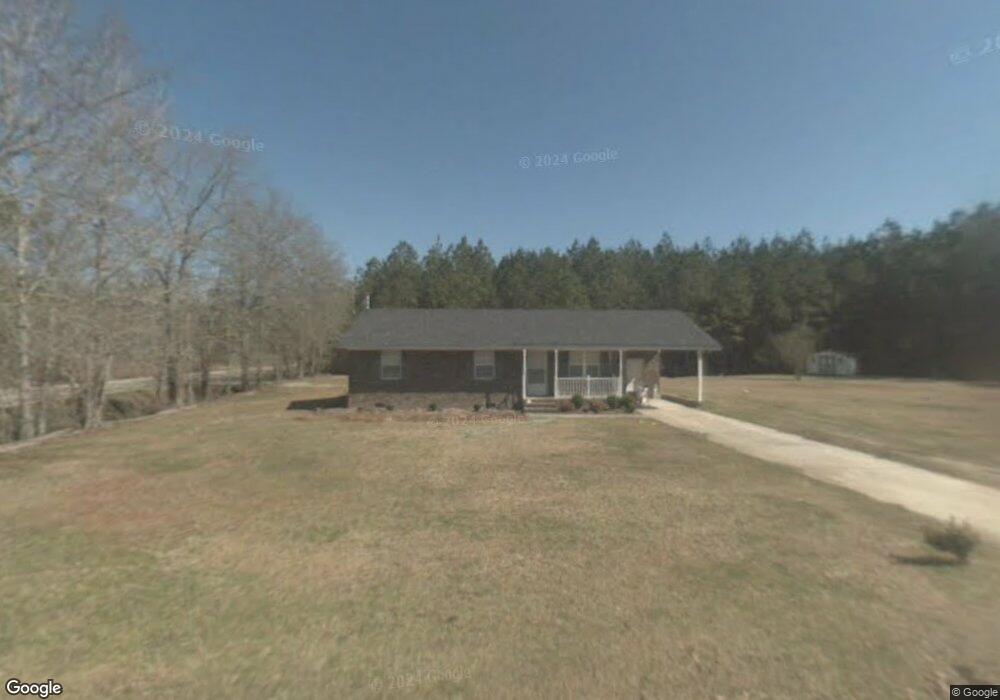
1916 Peddlers Ln Manning, SC 29102
Estimated Value: $162,000 - $184,000
3
Beds
1
Bath
1,039
Sq Ft
$168/Sq Ft
Est. Value
About This Home
This home is located at 1916 Peddlers Ln, Manning, SC 29102 and is currently estimated at $174,614, approximately $168 per square foot. 1916 Peddlers Ln is a home located in Clarendon County with nearby schools including Manning Early Childhood Center, Manning Primary School, and Manning Elementary School.
Ownership History
Date
Name
Owned For
Owner Type
Purchase Details
Closed on
Feb 28, 2025
Sold by
Thorp Myra Ann
Bought by
Dilts Teresa Elaine and Dilts Clyde John
Current Estimated Value
Home Financials for this Owner
Home Financials are based on the most recent Mortgage that was taken out on this home.
Original Mortgage
$148,750
Outstanding Balance
$148,013
Interest Rate
7.04%
Mortgage Type
New Conventional
Estimated Equity
$26,601
Create a Home Valuation Report for This Property
The Home Valuation Report is an in-depth analysis detailing your home's value as well as a comparison with similar homes in the area
Home Values in the Area
Average Home Value in this Area
Purchase History
| Date | Buyer | Sale Price | Title Company |
|---|---|---|---|
| Dilts Teresa Elaine | $175,000 | None Listed On Document | |
| Dilts Teresa Elaine | $175,000 | None Listed On Document |
Source: Public Records
Mortgage History
| Date | Status | Borrower | Loan Amount |
|---|---|---|---|
| Open | Dilts Teresa Elaine | $148,750 | |
| Closed | Dilts Teresa Elaine | $148,750 |
Source: Public Records
Tax History Compared to Growth
Tax History
| Year | Tax Paid | Tax Assessment Tax Assessment Total Assessment is a certain percentage of the fair market value that is determined by local assessors to be the total taxable value of land and additions on the property. | Land | Improvement |
|---|---|---|---|---|
| 2024 | $242 | $2,932 | $320 | $2,612 |
| 2023 | $239 | $2,932 | $320 | $2,612 |
| 2022 | $616 | $2,932 | $320 | $2,612 |
| 2021 | $523 | $2,740 | $280 | $2,460 |
| 2020 | $523 | $2,740 | $280 | $2,460 |
| 2019 | $484 | $2,740 | $280 | $2,460 |
| 2018 | $455 | $2,740 | $0 | $0 |
| 2017 | $455 | $2,740 | $0 | $0 |
| 2016 | $440 | $2,740 | $0 | $0 |
| 2015 | $450 | $2,764 | $280 | $2,484 |
| 2014 | $443 | $2,764 | $280 | $2,484 |
| 2013 | -- | $2,764 | $280 | $2,484 |
Source: Public Records
Map
Nearby Homes
- 7142 Bloomville Rd
- 2885 Mallett Rd
- 00 Archer Ave
- 00 Mallett Rd
- 1321 Herod Dr
- 00 lot3 Meagen Ln
- 00 lot2 Meagen Ln
- 00 lot1 Meagen Ln
- 1252 Hoffman Dr Unit Lot D
- 1252 Hoffman Dr Unit Lot C
- 1252 Hoffman Dr
- 1060 Hideout Dr
- 821 Bentwood Cir
- 813 Bentwood Cir
- 0 Silver Rd Unit 590087
- 1158 Dewitt St
- 1101 Birch Haven Dr
- 8199 Moses Dingle Rd
- 1349 Patton Rd
- 2552 Joseph Lemon and Dingle Rd Unit 6
- 1444 Liberty Church Rd
- 1396 Liberty Church Rd
- 1429 Liberty Church Rd
- 1739 Peddlers Ln
- 1282 Liberty Church Rd
- 1238 Liberty Church Rd
- 1233 Liberty Church Rd
- 1364 Peddlers Ln
- 6239 Bloomville Rd
- 6119 Bloomville Rd
- 6081 Bloomville Rd
- 3886 Brewer Rd
- 4076 Brewer Rd
- 6330 Bloomville Rd
- 5879 Bloomville Rd
- 6396 Bloomville Rd
- 1312 Peddlers Ln
- 6621 Bloomville Rd
- 6514 Bloomville Rd
- 3567 Brewer Rd