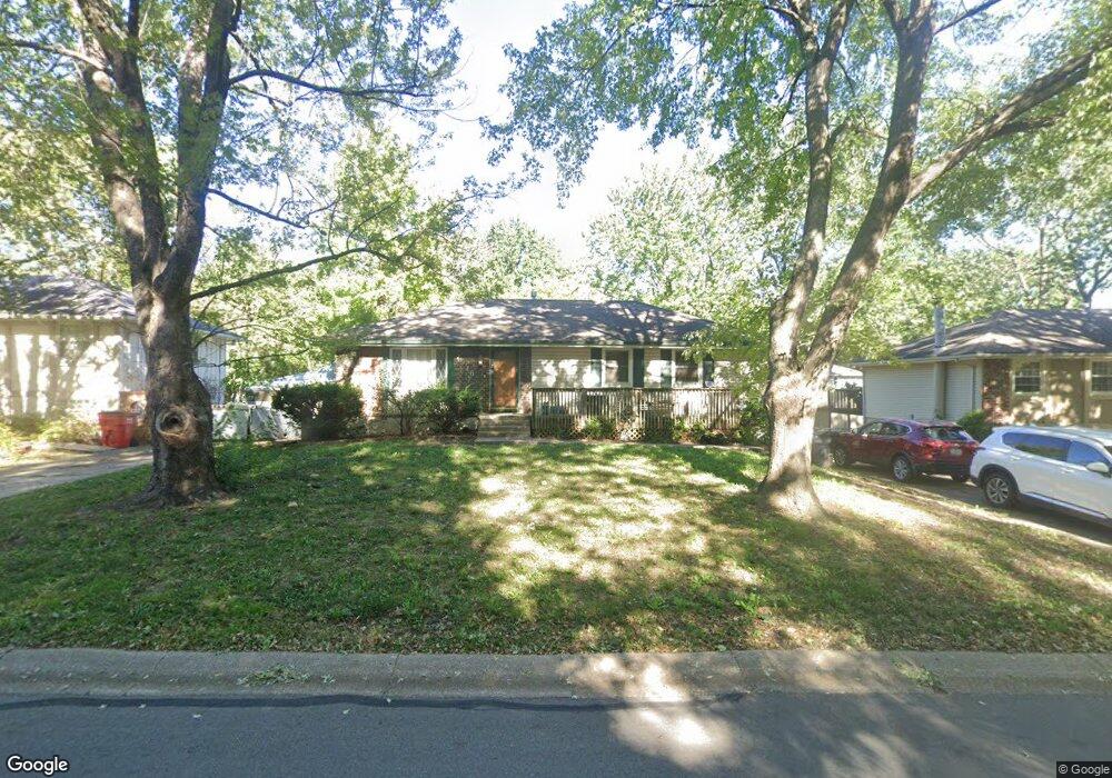
1916 SW Keystone Dr Blue Springs, MO 64014
Estimated Value: $243,212 - $268,000
3
Beds
2
Baths
1,104
Sq Ft
$233/Sq Ft
Est. Value
About This Home
This home is located at 1916 SW Keystone Dr, Blue Springs, MO 64014 and is currently estimated at $257,553, approximately $233 per square foot. 1916 SW Keystone Dr is a home located in Jackson County with nearby schools including Daniel Young Elementary School, Moreland Ridge Middle School, and Blue Springs South High School.
Ownership History
Date
Name
Owned For
Owner Type
Purchase Details
Closed on
Dec 22, 2022
Sold by
Paula Melugin Living Trust and Melugin Paula S
Bought by
Paula Melugin Living Trust and Melugin
Current Estimated Value
Home Financials for this Owner
Home Financials are based on the most recent Mortgage that was taken out on this home.
Original Mortgage
$110,000
Outstanding Balance
$106,469
Interest Rate
6.58%
Mortgage Type
New Conventional
Estimated Equity
$151,084
Purchase Details
Closed on
Jul 1, 2020
Sold by
Melugin Paula S
Bought by
Melugin Paula S and Paula Melugin Living Trust
Create a Home Valuation Report for This Property
The Home Valuation Report is an in-depth analysis detailing your home's value as well as a comparison with similar homes in the area
Home Values in the Area
Average Home Value in this Area
Purchase History
| Date | Buyer | Sale Price | Title Company |
|---|---|---|---|
| Paula Melugin Living Trust | -- | None Listed On Document | |
| Melugin Paula S | -- | None Available |
Source: Public Records
Mortgage History
| Date | Status | Borrower | Loan Amount |
|---|---|---|---|
| Open | Paula Melugin Living Trust | $110,000 |
Source: Public Records
Tax History Compared to Growth
Tax History
| Year | Tax Paid | Tax Assessment Tax Assessment Total Assessment is a certain percentage of the fair market value that is determined by local assessors to be the total taxable value of land and additions on the property. | Land | Improvement |
|---|---|---|---|---|
| 2025 | $3,211 | $29,901 | $6,407 | $23,494 |
| 2024 | $3,211 | $39,360 | $4,913 | $34,447 |
| 2023 | $3,149 | $39,360 | $5,031 | $34,329 |
| 2022 | $2,047 | $22,610 | $4,836 | $17,774 |
| 2021 | $2,045 | $22,610 | $4,836 | $17,774 |
| 2020 | $1,919 | $21,579 | $4,836 | $16,743 |
| 2019 | $1,855 | $21,579 | $4,836 | $16,743 |
| 2018 | $1,905 | $21,329 | $3,535 | $17,794 |
| 2017 | $1,905 | $21,329 | $3,535 | $17,794 |
| 2016 | $1,853 | $20,795 | $3,419 | $17,376 |
| 2014 | $1,822 | $20,387 | $3,352 | $17,035 |
Source: Public Records
Map
Nearby Homes
- 1820 SW Keystone Dr
- 1628 SE 1st Street Terrace
- 1616 SE 1st Street Terrace
- 1917 SE Abbey St
- 1901 SW Gladstone Dr
- 204 SE Cromwell St
- 4805 SW 6th St
- 4809 SW 6th St
- 1305 S Ward Pkwy
- 2317 SE 7th St
- 2115 S 7 Hwy
- 309 SE Shawn Ct
- 505 SE Gingerbread Ln
- 1005 SE Alice St
- 1300 SE Piccadilly St
- 1208 SE Piccadilly St
- 105 SW Windsor Ct
- 404 SW Shamrock Place
- 408 SW Shamrock Place
- 1004 SW Hiawatha Dr
- 1912 SW Keystone Dr
- 1920 SW Keystone Dr
- 1908 SW Keystone Dr
- 1913 SW Keystone Dr
- 1924 SW Keystone Dr
- 1821 S Speas Dr
- 1917 SW Keystone Dr
- 1909 SW Keystone Dr
- 1813 S Speas Dr
- 1817 S Speas Dr
- 1904 SW Keystone Dr
- 1905 SW Keystone Dr
- 1901 S Speas Dr
- 1921 SW Keystone Dr
- 1928 SW Keystone Dr
- 1809 S Speas Dr
- 1905 S Speas Dr
- 116 SW Rockwood St
- 1805 SW Speas Dr
- 1900 SW Keystone Dr