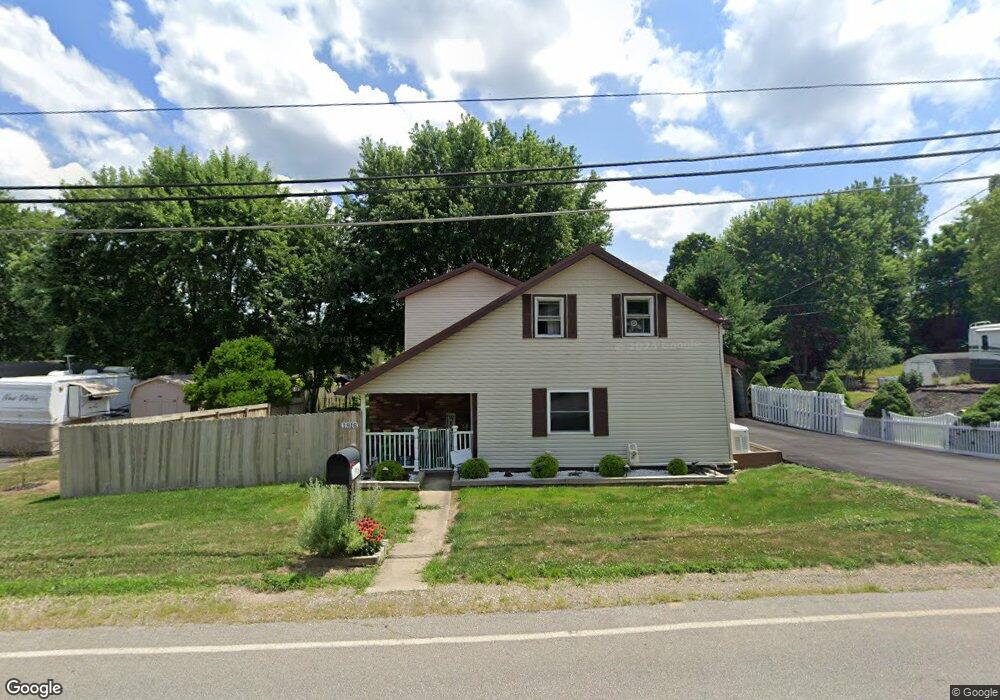
1916 Windsor Rd Mansfield, OH 44905
Estimated Value: $184,205 - $241,000
3
Beds
2
Baths
1,808
Sq Ft
$115/Sq Ft
Est. Value
About This Home
This home is located at 1916 Windsor Rd, Mansfield, OH 44905 and is currently estimated at $207,551, approximately $114 per square foot. 1916 Windsor Rd is a home located in Richland County with nearby schools including Madison High School and St. Mary Catholic School.
Ownership History
Date
Name
Owned For
Owner Type
Purchase Details
Closed on
Jun 25, 2021
Sold by
Pendleton Jerry L and Pendleton Vicki
Bought by
Pendleton Jerry L and Pendleton Vickie
Current Estimated Value
Purchase Details
Closed on
Jan 22, 2021
Sold by
Pendleton Jerry L and Pendleton Vickie
Bought by
Pendleton Jerry L and Pendleton Vickie
Purchase Details
Closed on
Oct 9, 2015
Sold by
Pendleton Jerry L
Bought by
Pendleton Jerry L and Pendleton Vickie
Home Financials for this Owner
Home Financials are based on the most recent Mortgage that was taken out on this home.
Original Mortgage
$70,200
Interest Rate
3.97%
Mortgage Type
VA
Create a Home Valuation Report for This Property
The Home Valuation Report is an in-depth analysis detailing your home's value as well as a comparison with similar homes in the area
Home Values in the Area
Average Home Value in this Area
Purchase History
| Date | Buyer | Sale Price | Title Company |
|---|---|---|---|
| Pendleton Jerry L | -- | None Available | |
| Pendleton Jerry L | -- | None Available | |
| Pendleton Jerry L | -- | Servicelink |
Source: Public Records
Mortgage History
| Date | Status | Borrower | Loan Amount |
|---|---|---|---|
| Closed | Pendleton Jerry L | $70,200 |
Source: Public Records
Tax History Compared to Growth
Tax History
| Year | Tax Paid | Tax Assessment Tax Assessment Total Assessment is a certain percentage of the fair market value that is determined by local assessors to be the total taxable value of land and additions on the property. | Land | Improvement |
|---|---|---|---|---|
| 2024 | $1,093 | $40,540 | $3,290 | $37,250 |
| 2023 | $1,093 | $40,540 | $3,290 | $37,250 |
| 2022 | $1,557 | $28,270 | $2,640 | $25,630 |
| 2021 | $1,556 | $28,270 | $2,640 | $25,630 |
| 2020 | $1,568 | $28,270 | $2,640 | $25,630 |
| 2019 | $1,425 | $23,970 | $2,220 | $21,750 |
| 2018 | $1,265 | $21,440 | $2,220 | $19,220 |
| 2017 | $1,186 | $19,420 | $2,220 | $17,200 |
| 2016 | $1,248 | $21,070 | $2,110 | $18,960 |
| 2015 | $1,228 | $21,070 | $2,110 | $18,960 |
| 2014 | $1,224 | $21,070 | $2,110 | $18,960 |
| 2012 | $593 | $22,170 | $2,220 | $19,950 |
Source: Public Records
Map
Nearby Homes
- 2202 Lakewood Dr
- 1951 Woodmont Rd
- 1997 Hout Rd
- 1806 Richard Dr
- 1292 Wolford Rd
- 1910 Crider Rd
- 1791 Beal Rd
- 1171 Hoover Rd
- 1585 Beal Rd
- 1106 Keller Dr Unit 1108
- 2270 Lakecrest Dr Unit 2272
- 903 Mayflower Ave
- 0 Hoover Rd
- 1151 Beal Rd
- 1158 Delwood Rd
- 1150 Delwood Dr
- 1245 N Stewart Rd
- 920 Piper Rd
- 0 Satinwood Dr
- 640 Running Brook Way
- 1934 Windsor Rd
- 1934 Windsor Rd
- 1908 Windsor Rd
- 1917 Windsor Rd
- 1935 Windsor Rd
- 1915 Windsor Rd
- 1904 Windsor Rd
- 1907 Windsor Rd
- 1936 Windsor Rd
- 1738 Hale Rd
- 1902 Windsor Rd
- 1613 Windsor Rd
- 1950 Windsor Rd
- 1950 Windsor Rd
- 1903 Windsor Rd
- 1759 Hale Rd
- 1897 Windsor Rd
- 2111 Lakewood Dr
- 1959 Windsor Rd
- 2125 Lakewood Dr