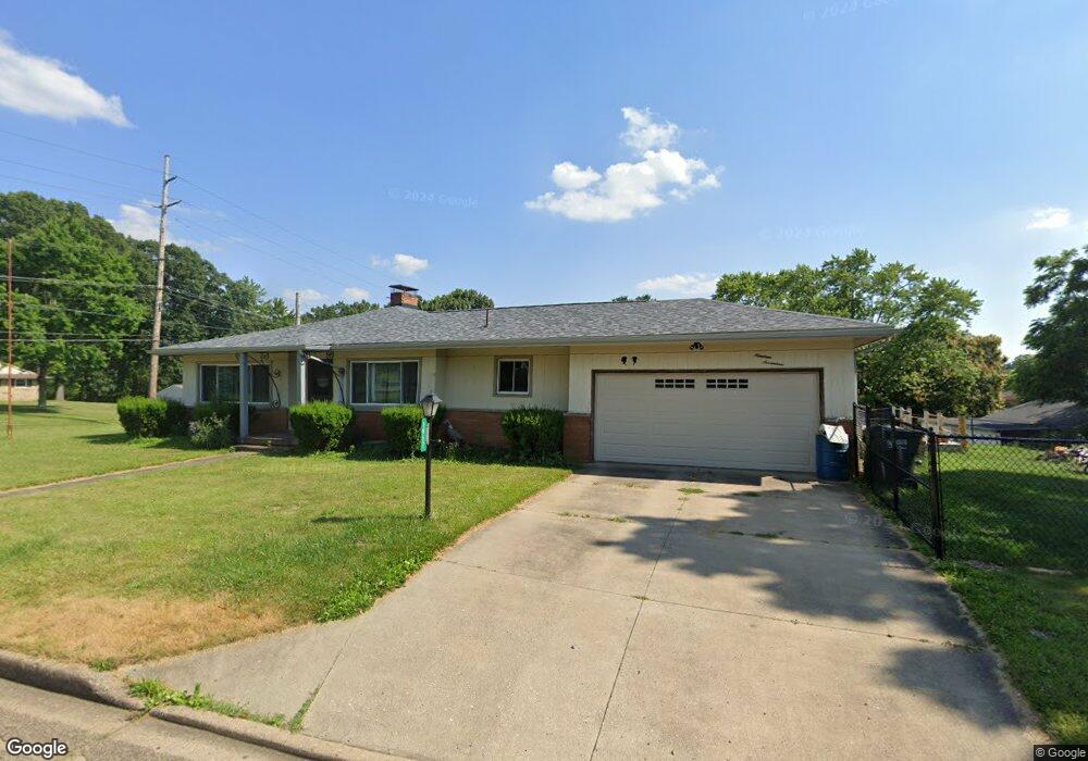
1917 Amherst Rd NE Massillon, OH 44646
Amherst Heights-Clearview NeighborhoodEstimated Value: $187,000 - $263,000
3
Beds
2
Baths
1,682
Sq Ft
$136/Sq Ft
Est. Value
About This Home
This home is located at 1917 Amherst Rd NE, Massillon, OH 44646 and is currently estimated at $229,200, approximately $136 per square foot. 1917 Amherst Rd NE is a home located in Stark County with nearby schools including Massillon Intermediate School, Massillon Junior High School, and Washington High School.
Ownership History
Date
Name
Owned For
Owner Type
Purchase Details
Closed on
Nov 23, 2020
Sold by
Leonard Nancy E and Leonard Jerry P
Bought by
Leonard Brian and Leonard Michelle
Current Estimated Value
Home Financials for this Owner
Home Financials are based on the most recent Mortgage that was taken out on this home.
Original Mortgage
$63,822
Outstanding Balance
$56,793
Interest Rate
2.8%
Mortgage Type
FHA
Estimated Equity
$172,407
Purchase Details
Closed on
Feb 3, 2020
Sold by
Kracker David A
Bought by
Leonard Nancy E and Leonard Jerry P
Purchase Details
Closed on
Jan 30, 2020
Sold by
Leonard Nancy E
Bought by
Leonard Nancy E and Kracker David A
Create a Home Valuation Report for This Property
The Home Valuation Report is an in-depth analysis detailing your home's value as well as a comparison with similar homes in the area
Home Values in the Area
Average Home Value in this Area
Purchase History
| Date | Buyer | Sale Price | Title Company |
|---|---|---|---|
| Leonard Brian | $65,000 | Quest Title | |
| Leonard Nancy E | -- | None Available | |
| Leonard Nancy E | -- | None Available |
Source: Public Records
Mortgage History
| Date | Status | Borrower | Loan Amount |
|---|---|---|---|
| Open | Leonard Brian | $63,822 |
Source: Public Records
Tax History Compared to Growth
Tax History
| Year | Tax Paid | Tax Assessment Tax Assessment Total Assessment is a certain percentage of the fair market value that is determined by local assessors to be the total taxable value of land and additions on the property. | Land | Improvement |
|---|---|---|---|---|
| 2025 | -- | $48,450 | $14,740 | $33,710 |
| 2024 | -- | $48,450 | $14,740 | $33,710 |
| 2023 | $2,105 | $41,160 | $10,780 | $30,380 |
| 2022 | $2,108 | $41,160 | $10,780 | $30,380 |
| 2021 | $2,142 | $41,160 | $10,780 | $30,380 |
| 2020 | $2,084 | $36,690 | $9,910 | $26,780 |
| 2019 | $1,519 | $36,690 | $9,910 | $26,780 |
| 2018 | $1,516 | $36,690 | $9,910 | $26,780 |
| 2017 | $1,446 | $33,640 | $8,860 | $24,780 |
| 2016 | $1,470 | $33,640 | $8,860 | $24,780 |
| 2015 | $1,452 | $33,640 | $8,860 | $24,780 |
| 2014 | $1,457 | $32,900 | $8,680 | $24,220 |
| 2013 | $733 | $32,900 | $8,680 | $24,220 |
Source: Public Records
Map
Nearby Homes
- 811 Sandy Ave NE
- 365 Hamilton Ave NE
- 1659 Dexter Rd NE
- 1209 Providence Rd NE
- 1056 Taggart St NW
- 1635 Jolynn St NE
- 1204 Taggart St NW
- 1312 Lennox Ave NE
- 1717 Chittenden Cir NE
- 3060 Erie Ave NW
- 1267 Plymouth St NW
- 210 Mccadden Ave NE
- 742 Sheffield Ave NE
- 3315 Broadhaven Ave NW
- 8625 Milmont St NW
- Grand Cayman w/ Basement Plan at Sippo Reserves
- Eden Cay w/ Basement Plan at Sippo Reserves
- Aruba Bay w/ Basement Plan at Sippo Reserves
- Grand Bahama w/ Basement Plan at Sippo Reserves
- 3252 Stahl Ave NW
- 1915 Amherst Rd NE
- 1933 Amherst Rd NE
- 625 Lori Ave NE
- 1913 Amherst Rd NE
- 506 Shaw Ave NE
- 630 Lori Ave NE
- 502 Shaw Ave NE
- 1941 Amherst Rd NE
- 622 Lori Ave NE
- 450 Shaw Ave NE
- 615 Lori Ave NE
- 1934 Amherst Rd NE
- 444 Shaw Ave NE
- 614 Lori Ave NE
- 1911 Amherst Rd NE
- 1950 Amherst Rd NE
- 1922 Amherst Rd NE
- 639 Terry Ave NE
- 629 Terry Ave NE
- 2001 Amherst Rd NE