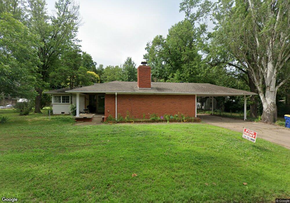
1917 W University Ave Stillwater, OK 74074
Estimated Value: $291,000 - $342,000
3
Beds
2
Baths
2,152
Sq Ft
$146/Sq Ft
Est. Value
About This Home
This home is located at 1917 W University Ave, Stillwater, OK 74074 and is currently estimated at $313,742, approximately $145 per square foot. 1917 W University Ave is a home located in Payne County with nearby schools including Westwood Elementary School, Stillwater Middle School, and Stillwater Junior High School.
Ownership History
Date
Name
Owned For
Owner Type
Purchase Details
Closed on
Apr 18, 2006
Sold by
Woodford Thomas J and Woodford Elizabeth M
Bought by
Ahrens Douglas K and Twist Jacquliner
Current Estimated Value
Home Financials for this Owner
Home Financials are based on the most recent Mortgage that was taken out on this home.
Original Mortgage
$132,800
Outstanding Balance
$75,292
Interest Rate
6.32%
Mortgage Type
New Conventional
Estimated Equity
$238,450
Create a Home Valuation Report for This Property
The Home Valuation Report is an in-depth analysis detailing your home's value as well as a comparison with similar homes in the area
Home Values in the Area
Average Home Value in this Area
Purchase History
| Date | Buyer | Sale Price | Title Company |
|---|---|---|---|
| Ahrens Douglas K | $166,000 | Community Escrow & Title Co |
Source: Public Records
Mortgage History
| Date | Status | Borrower | Loan Amount |
|---|---|---|---|
| Open | Ahrens Douglas K | $132,800 |
Source: Public Records
Tax History Compared to Growth
Tax History
| Year | Tax Paid | Tax Assessment Tax Assessment Total Assessment is a certain percentage of the fair market value that is determined by local assessors to be the total taxable value of land and additions on the property. | Land | Improvement |
|---|---|---|---|---|
| 2025 | $2,620 | $25,873 | $8,903 | $16,970 |
| 2024 | $2,505 | $24,641 | $8,415 | $16,226 |
| 2023 | $2,505 | $23,468 | $9,039 | $14,429 |
| 2022 | $2,262 | $22,350 | $8,986 | $13,364 |
| 2021 | $2,111 | $21,286 | $8,919 | $12,367 |
| 2020 | $2,011 | $20,273 | $8,079 | $12,194 |
| 2019 | $1,957 | $19,308 | $7,695 | $11,613 |
| 2018 | $1,860 | $18,388 | $7,329 | $11,059 |
| 2017 | $1,769 | $17,513 | $9,690 | $7,823 |
| 2016 | $1,807 | $17,513 | $9,690 | $7,823 |
| 2015 | $1,832 | $17,513 | $9,690 | $7,823 |
| 2014 | $1,790 | $16,965 | $9,142 | $7,823 |
Source: Public Records
Map
Nearby Homes
- 132 S Mcfarland St
- 2130 W Sunset Ave
- 409 S Orchard St
- 2133 W Arrowhead Dr
- 129 S Monticello Dr
- 612 S Kings St
- 801 S Monroe St
- 1306 W 11th Ave
- 1116 S Adams St
- 913 & 913 1/2 W 10th Ave
- 2 Walnut Cir
- 11 W Glencoe Rd
- 709 W 10th Ave
- 201 S West St Unit 413 W. Maple
- 413 W Maple Ave Unit 201 S West
- 811 S Knoblock St
- 724 S West St Unit 512 W 8th
- 811 S West St
- 3798 N Knoblock St
- 251 W Miller #319 Ave
- 1921 W University Ave
- 1903 W University Ave
- 1900 W 3rd Ave
- 2002 W 3rd Ave
- 222 S Kings St
- 1920 W University Ave
- 1924 W University Ave
- 2010 W 3rd Ave
- 1910 W University Ave
- 2001 W University Ave
- 1902 W University Ave
- 210 S Kings St
- 149 S Mcfarland St
- 221 S Kings St
- 2020 W 3rd Ave
- 1911 W 3rd Ave
- 1915 W 3rd Ave
- 164 S Kings St
- 2022 W University Ave
- 1823 W University Ave