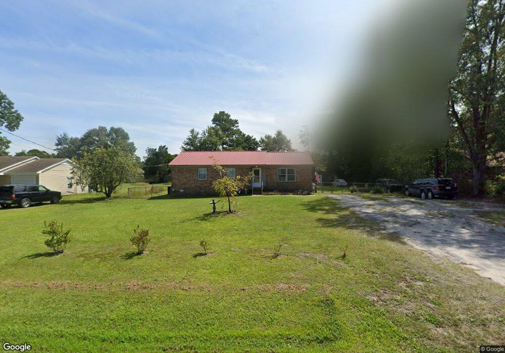
1918 Farley Dr Wilmington, NC 28405
Estimated Value: $291,000 - $378,000
3
Beds
2
Baths
1,133
Sq Ft
$283/Sq Ft
Est. Value
About This Home
This home is located at 1918 Farley Dr, Wilmington, NC 28405 and is currently estimated at $320,765, approximately $283 per square foot. 1918 Farley Dr is a home located in New Hanover County with nearby schools including Wrightsboro Elementary School, Holly Shelter Middle School, and Emsley A. Laney High School.
Ownership History
Date
Name
Owned For
Owner Type
Purchase Details
Closed on
Nov 13, 2013
Sold by
Gentry John Lee and Gentry Odette T
Bought by
Gentry Calvin
Current Estimated Value
Home Financials for this Owner
Home Financials are based on the most recent Mortgage that was taken out on this home.
Original Mortgage
$60,000
Outstanding Balance
$44,567
Interest Rate
4.13%
Mortgage Type
New Conventional
Estimated Equity
$276,198
Purchase Details
Closed on
May 1, 1986
Sold by
Kenton John Edith S
Bought by
Gentry John Lee Odette T
Purchase Details
Closed on
Mar 1, 1981
Sold by
H & H Limited
Bought by
Kenton John Edith S
Purchase Details
Closed on
Dec 1, 1979
Bought by
H & H Limited
Create a Home Valuation Report for This Property
The Home Valuation Report is an in-depth analysis detailing your home's value as well as a comparison with similar homes in the area
Home Values in the Area
Average Home Value in this Area
Purchase History
| Date | Buyer | Sale Price | Title Company |
|---|---|---|---|
| Gentry Calvin | $75,000 | None Available | |
| Gentry John Lee Odette T | $45,000 | -- | |
| Kenton John Edith S | $37,600 | -- | |
| H & H Limited | $26,300 | -- |
Source: Public Records
Mortgage History
| Date | Status | Borrower | Loan Amount |
|---|---|---|---|
| Open | Gentry Calvin | $60,000 |
Source: Public Records
Tax History Compared to Growth
Tax History
| Year | Tax Paid | Tax Assessment Tax Assessment Total Assessment is a certain percentage of the fair market value that is determined by local assessors to be the total taxable value of land and additions on the property. | Land | Improvement |
|---|---|---|---|---|
| 2025 | $992 | $313,000 | $79,100 | $233,900 |
| 2023 | $992 | $175,700 | $78,600 | $97,100 |
| 2022 | $995 | $175,700 | $78,600 | $97,100 |
| 2021 | $974 | $175,700 | $78,600 | $97,100 |
| 2020 | $929 | $146,800 | $32,900 | $113,900 |
| 2019 | $725 | $114,700 | $32,900 | $81,800 |
| 2018 | $725 | $114,700 | $32,900 | $81,800 |
| 2017 | $743 | $114,700 | $32,900 | $81,800 |
| 2016 | $681 | $98,300 | $32,900 | $65,400 |
| 2015 | $633 | $98,300 | $32,900 | $65,400 |
| 2014 | $622 | $98,300 | $32,900 | $65,400 |
Source: Public Records
Map
Nearby Homes
- 1933 N Kerr Ave
- 1916 Simonton Dr
- 129 Elder Dr
- 4418 Dewberry Rd
- 314 Brookfield Dr
- 318 Springdale Dr
- 4621 W Gate Rd
- 2509 N Kerr Ave
- 2104 Cornelius Moore Ave
- 1571 Grey Cliff Run
- 1535 Grey Cliff
- 1527 Grey Cliff
- 136 Blount Dr
- 4624 Runaway Bay Ln
- 3615 Leaning Tree Ct
- 2805 Colonel Lamb Dr
- 4302 Reed Ct
- 141 Hargrove Dr
- 2801 Hobart Dr
- 4335 Reed Ct
- 1922 Farley Dr
- 1914 Farley Dr
- 1905 N Kerr Ave
- 1926 Farley Dr
- 1910 Farley Dr
- 1909 N Kerr Ave
- 1901 N Kerr Ave
- 1913 N Kerr Ave
- 1859 N Kerr Ave
- 1930 Farley Dr
- 1906 Farley Dr
- 1917 N Kerr Ave
- 1855 N Kerr Ave
- 1934 Farley Dr
- 1902 Farley Dr
- 1921 N Kerr Ave
- 1938 Farley Dr
- 1860 N Kerr Ave
- 1925 N Kerr Ave
- 1850 Farley Dr