Estimated Value: $246,000 - $391,000
4
Beds
1
Bath
1,504
Sq Ft
$208/Sq Ft
Est. Value
About This Home
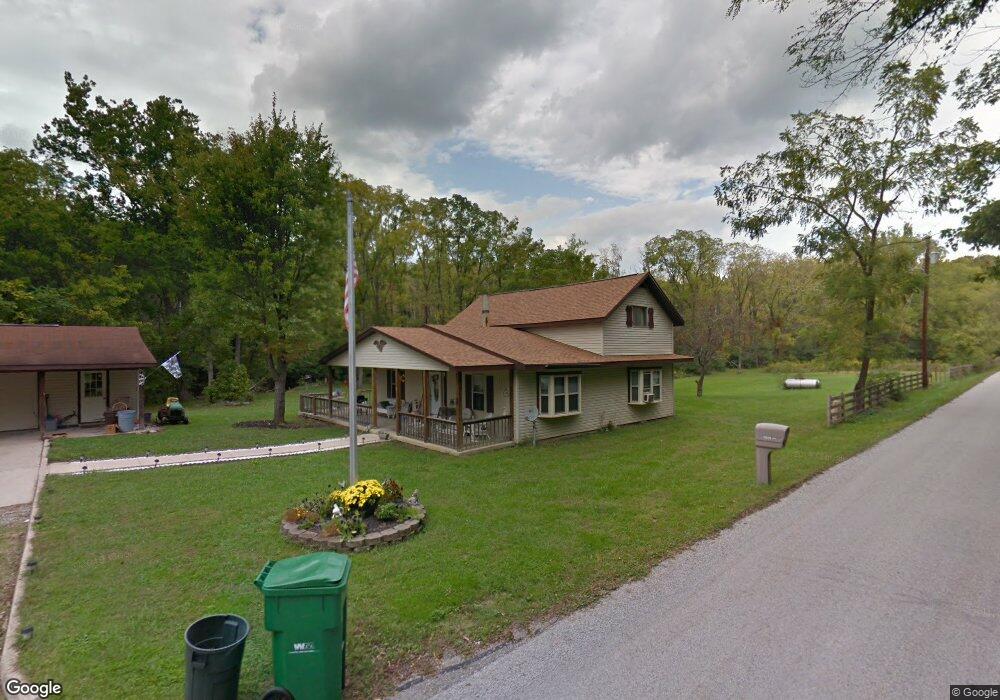
This home is located at 1919 Schnebly Rd, Xenia, OH 45385 and is currently estimated at $312,580, approximately $207 per square foot. 1919 Schnebly Rd is a home located in Greene County with nearby schools including Xenia High School.
Ownership History
Date
Name
Owned For
Owner Type
Purchase Details
Closed on
Dec 20, 2017
Sold by
Mccoy Daniel R
Bought by
Mccoy Daniel R and Mccoy Joyce J
Current Estimated Value
Purchase Details
Closed on
Jul 22, 1991
Bought by
Mccoy Daniel R
Create a Home Valuation Report for This Property
The Home Valuation Report is an in-depth analysis detailing your home's value as well as a comparison with similar homes in the area
Home Values in the Area
Average Home Value in this Area
Purchase History
| Date | Buyer | Sale Price | Title Company |
|---|---|---|---|
| Mccoy Daniel R | -- | -- | |
| Mccoy Daniel R | $84,900 | -- |
Source: Public Records
Tax History Compared to Growth
Tax History
| Year | Tax Paid | Tax Assessment Tax Assessment Total Assessment is a certain percentage of the fair market value that is determined by local assessors to be the total taxable value of land and additions on the property. | Land | Improvement |
|---|---|---|---|---|
| 2024 | $3,904 | $78,050 | $27,460 | $50,590 |
| 2023 | $3,904 | $78,050 | $27,460 | $50,590 |
| 2022 | $3,671 | $63,350 | $25,740 | $37,610 |
| 2021 | $3,715 | $63,350 | $25,740 | $37,610 |
| 2020 | $3,405 | $63,350 | $25,740 | $37,610 |
| 2019 | $3,146 | $54,850 | $21,860 | $32,990 |
| 2018 | $3,103 | $54,850 | $21,860 | $32,990 |
| 2017 | $2,988 | $54,850 | $21,860 | $32,990 |
| 2016 | $2,989 | $52,890 | $21,160 | $31,730 |
| 2015 | $2,997 | $52,890 | $21,160 | $31,730 |
| 2014 | $2,877 | $52,890 | $21,160 | $31,730 |
Source: Public Records
Map
Nearby Homes
- 1839 Simison Rd
- 1681 Valley Heights Rd
- 196 Mound St
- 2336 Washington Mill Rd
- Chatham Plan at Edenbridge
- Bellamy Plan at Edenbridge
- Holcombe Plan at Edenbridge
- Henley Plan at Edenbridge
- Newcastle Plan at Edenbridge
- 1474 Hawkshead St
- 1292 Baybury Ave
- 1272 Baybury Ave
- 1293 Baybury Ave
- 1256 Baybury Ave
- 1282 Baybury Ave
- 1298 Baybury Ave
- 1304 Baybury Ave
- 1358 Shannon Ln
- 2821 Raxit Ct
- 1318 Prem Place
- 0 Schnebly Rd Unit 623958
- 1860 Schnebly Rd
- 1833 Schnebly Rd
- 1789 Schnebly Rd
- 1845 Schnebly Rd
- 1840 Schnebly Rd
- 1710 Richland Rd
- 1820 Schnebly Rd
- 1727 Richland Rd
- 2060 Schnebly Rd
- 1821 Schnebly Rd
- 1675 Richland Rd
- 1542 Richland Rd
- 1685 Lower Bellbrook Rd
- 0 Richland Unit 428860
- 0 Richland Unit 782574
- 1786 Richland Rd
- 1765 Schnebly Rd
- 1695 Lower Bellbrook Rd
- 1553 Richland Rd