NOT LISTED FOR SALE

19195 S Highway 170 West Fork, AR 72774

Estimated Value: $259,668 - $362,000

100 Acres
$3,108 Price per Acre
4,356,000 Sq Ft Lot

Last Sold April 30, 2019

Last sale price $170,000

Est. 83% increase in value since last sale

Current estimated payment $1,746/month

26 Days on Market

Highlights

  • 100 Acre Lot
  • Creek or Stream
  • Partially Fenced Property
  • Partially Wooded Lot

About This Lot

As of April 2019

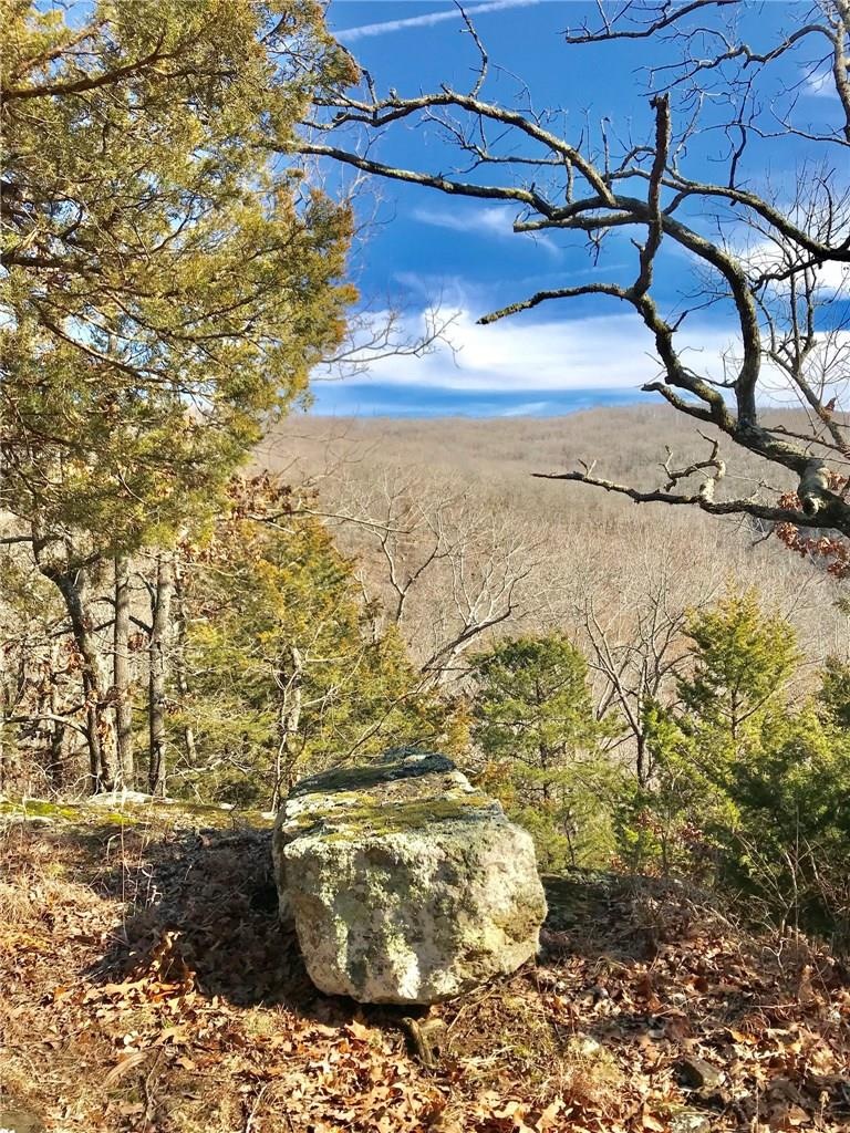
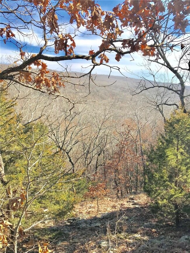
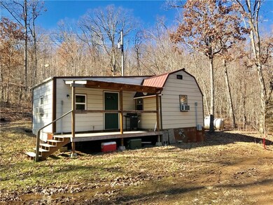
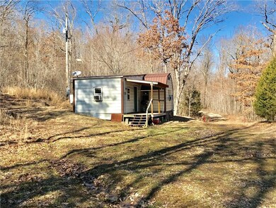
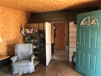
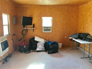
Hunter's PARADISE!!! REMOTE 100 Acres, a hunting cabin, deer stands in place, food plots, seasonal streams, natural rock & WILDLIFE galore. Recorded easement to the property. Property is located approx. 2 miles from Devil's Den Park. Approx 30 Acres were cleared several years ago and planted w/ Loblolly Pines. Pines are approx. 3 + feet tall. Approx. 70 Acres is wooded and has ATV trails. Cabin has electricity, propane tank, water is provided by a catch tank, 3 window units, 2 propane heat units.

Last Agent to Sell the Property

Melanie Chambers

RE/MAX Associates, LLC License #EB00056205 Listed on: 03/04/2019

RE/MAX Associates,  LLC

Last Buyer's Agent

Larry Marion

Bassett Mix And Associates, Inc License #SA00075506

Property Details

Property Type

  • Land

Est. Annual Taxes

  • $287

Lot Details

  • 100 Acre Lot
  • Property fronts a private road
  • Property fronts a highway
  • Creek or Stream
  • Rural Setting
  • Partially Fenced Property
  • Wire Fence
  • Steep Slope
  • Cleared Lot
  • Partially Wooded Lot
  • Landscaped with Trees

Home Design

  • Mixed Use

Additional Features

  • Outside City Limits
  • Mobile Home Allowed
  • Propane

Property Details

Property Type

Land

Est. Annual Taxes

$287

Lot Details

0

Listing Details

  • Property Sub Type: Mixed Use
  • Prop. Type: Land
  • Lot Size Acres: 100.0
  • Road Frontage Type: Highway, Private Road
  • Subdivision Name: .
  • Directions: From Fayetteville go south on I-49 to Exit 53/West Fork, R on Hwy 170 for 10.3 miles (pass Zinnamon Church) then R on RD 19107 (GPS address 19107 S Hwy 170, West Fork - Neighbo'rs address), travel on dirt road to fork and keep left at gate. Follow signs.
  • ResoPropertyType: Land
  • Special Features: None

Exterior Features

  • Fencing: Fenced, Partial, Wire
  • Lot Features: Cleared, Hardwood Trees, Mobile Home Allowed, Not In Subdivision, None, Outside City Limits, Rural Lot, Steep Slope, Stream/Creek, Wooded
  • Topography: Sloping

Utilities

  • Electricity On Property: Yes
  • Utilities: Propane, Electricity Available
  • Water Source: Other, See Remarks

Schools

  • Junior High Dist: West Fork

Lot Info

  • Additional Parcels Description: 001-01348-002, 001-01314-000,001-01298-001
  • Zoning Description: None
  • Zoning: N
  • ResoLotSizeUnits: Acres

Tax Info

  • Tax Annual Amount: 287.0
  • Tax Block: .
  • Tax Lot: .

Ownership History

Date Name Owned For Owner Type

Purchase Details

Closed on
Nov 25, 2003
Sold by
Bill Beam Professional Corp
Bought by
Beam Bill and Beam Joyce
Current Estimated Value
$310,834
Source: Public Records

Range of Values:

Collateral Analytics

Collateral Analytics Collateral Analytics AVMs (Automated Valuation Model) employ a number of statistical approaches combined with neighborhood-specific comparable selection guarantees the most up-to-date and precise valuations.

Not Available

Collateral Analytics does not have data for the current month. Please view the chart for historical values.

ICE

ICE Mortgage Technology ICE Mortgage Technology’s AVM (Automated Valuation Model) is a state-of-the-art online residential property valuation tool that provides a quick and accurate estimate of the value of almost any home in the U.S.

Not Available

ICE Mortgage Technology does not have data for the current month. Please view the chart for historical values.

First American

First American First American Data & Analytics’ next-generation AVM combines unrivaled data assets with a blended ensemble of valuation models to produce highly accurate, reliable valuations you can trust.

Not Available

First American does not have data for the current month. Please view the chart for historical values.

Quantarium

Quantarium Quantarium’s valuation service, repeatedly proven the industry’s most accurate and comprehensive, is supercharged with a self-learning and auto-tuning AI engine that continually becomes smarter and more accurate as it processes daily inputs from the industry’s leading RE data lake.

Not Available

Quantarium does not have data for the current month. Please view the chart for historical values.

Average Value
Not Available
List Price
Sold Price
Create a Home Valuation Report for This Property
The Home Valuation Report is an in-depth analysis detailing your home's value as well as a comparison with similar homes in the area

Home Values in the Area

Source: Public Records

Average Home Value in this Area


Source: Public Records

Purchase History

Date Buyer Sale Price Title Company
Beam Bill -- --
Source: Public Records

Property History

Date Event Price Change Sq Ft Price
04/30/2019 04/30/19 Sold $170,000 -15.0% --
03/31/2019 03/31/19 Pending -- -- --
03/04/2019 03/04/19 For Sale $200,000 -- --
Source: Northwest Arkansas Board of REALTORS®

Tax History Compared to Growth

Source: Public Records

Tax History

Year Tax Paid Tax Assessment Tax Assessment Total Assessment is a certain percentage of the fair market value that is determined by local assessors to be the total taxable value of land and additions on the property. Land Improvement
2024 $246 $6,910 $2,920 $3,990
2023 $227 $6,910 $2,920 $3,990
2022 $264 $4,850 $2,320 $2,530
2021 $248 $4,850 $2,320 $2,530
2020 $232 $3,630 $2,320 $1,310
2019 $216 $3,280 $2,140 $1,140
2018 $259 $4,180 $2,940 $1,240
2017 $195 $4,180 $2,940 $1,240
2016 $253 $4,180 $2,940 $1,240
2015 $253 $4,180 $2,940 $1,240
2014 $273 $4,620 $2,810 $1,810
Source: Public Records

Agents Affiliated with this Home

  • Section Image
  • Section Image
See All Agents

Map

Source: Northwest Arkansas Board of REALTORS®

MLS Number: 1105571

Northwest Arkansas Board of REALTORS®

APN: 001-01348-001