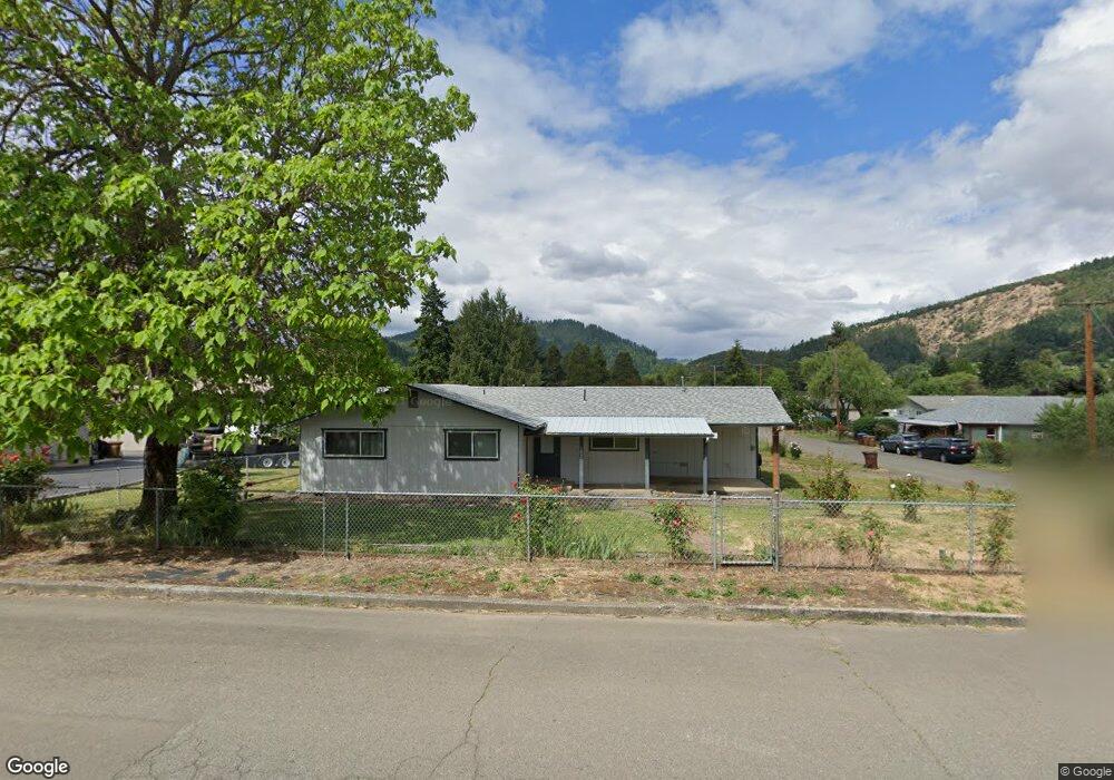
192 NE Neal Ln Myrtle Creek, OR 97457
Estimated Value: $312,194 - $371,000
3
Beds
2
Baths
1,350
Sq Ft
$253/Sq Ft
Est. Value
About This Home
This home is located at 192 NE Neal Ln, Myrtle Creek, OR 97457 and is currently estimated at $341,299, approximately $252 per square foot. 192 NE Neal Ln is a home located in Douglas County with nearby schools including South Umpqua High School.
Ownership History
Date
Name
Owned For
Owner Type
Purchase Details
Closed on
Dec 30, 2013
Sold by
Zahorik Crump Barbara L and Adams Dale Robert
Bought by
Schreiber Jameslee D
Current Estimated Value
Home Financials for this Owner
Home Financials are based on the most recent Mortgage that was taken out on this home.
Original Mortgage
$111,375
Outstanding Balance
$83,367
Interest Rate
4.17%
Mortgage Type
VA
Estimated Equity
$257,932
Purchase Details
Closed on
Jul 2, 2008
Sold by
Adams Theodore R and Adams Dorothy V
Bought by
Adams Theodore and Adams Dorothy
Create a Home Valuation Report for This Property
The Home Valuation Report is an in-depth analysis detailing your home's value as well as a comparison with similar homes in the area
Home Values in the Area
Average Home Value in this Area
Purchase History
| Date | Buyer | Sale Price | Title Company |
|---|---|---|---|
| Schreiber Jameslee D | $130,000 | Ticor Title | |
| Adams Theodore | -- | None Available |
Source: Public Records
Mortgage History
| Date | Status | Borrower | Loan Amount |
|---|---|---|---|
| Open | Schreiber Jameslee D | $111,375 |
Source: Public Records
Tax History Compared to Growth
Tax History
| Year | Tax Paid | Tax Assessment Tax Assessment Total Assessment is a certain percentage of the fair market value that is determined by local assessors to be the total taxable value of land and additions on the property. | Land | Improvement |
|---|---|---|---|---|
| 2024 | $2,539 | $189,832 | -- | -- |
| 2023 | $2,465 | $184,303 | $0 | $0 |
| 2022 | $2,393 | $178,935 | $0 | $0 |
| 2021 | $2,324 | $173,724 | $0 | $0 |
| 2020 | $2,256 | $168,665 | $0 | $0 |
| 2019 | $2,190 | $163,753 | $0 | $0 |
| 2018 | $2,126 | $158,984 | $0 | $0 |
| 2017 | $2,026 | $154,354 | $0 | $0 |
| 2016 | $1,927 | $149,859 | $0 | $0 |
| 2015 | $1,873 | $145,495 | $0 | $0 |
| 2014 | $1,846 | $141,258 | $0 | $0 |
| 2013 | -- | $137,144 | $0 | $0 |
Source: Public Records
Map
Nearby Homes
- 195 NE Sandy Terrace
- 231 Chestnut St
- 961 NE Broadway St
- 0 NE Simpson Ln Unit 734646510
- 1357 NE Ballard Ct
- 650 SE Riverside Dr
- 629 NE Johnson St
- 455 Woody Ct
- 910 NE Leon Ave
- 1682 Riverside Dr
- 1682 NE Riverside Dr
- 407 NE Waite St
- 119 Forest Rd
- 186 NE Division St
- 206 NE Laurel Ave
- 769 NE Christian St
- 217 SE Mill St
- 195 SE Mill St
- 1056 NE Orchard Dr
- 728 NW Morrison Ave
- 190 NE Neal Ln
- 974 NE Bond St
- 991 NE Bond St
- 971 NE Bond St
- 960 NE Bond St
- 196 Darcie Way
- 184 Darcie Way
- 178 NE Neal Ln
- 0 NE Neal Ln
- 222 Darcie Way
- 978 NE Broadway St
- 990 NE Broadway St
- 178 NE Darcie Way
- 951 NE Bond St
- 966 NE Broadway St
- 930 NE Bond St
- 941 NE Bond St
- 989 NE Jenny Ln
- 170 NE Darcie Way
- 969 NE Jenny Ln