192 Progresso Ave Woonsocket, RI 02895
East Woonsocket NeighborhoodEstimated Value: $418,000 - $516,000
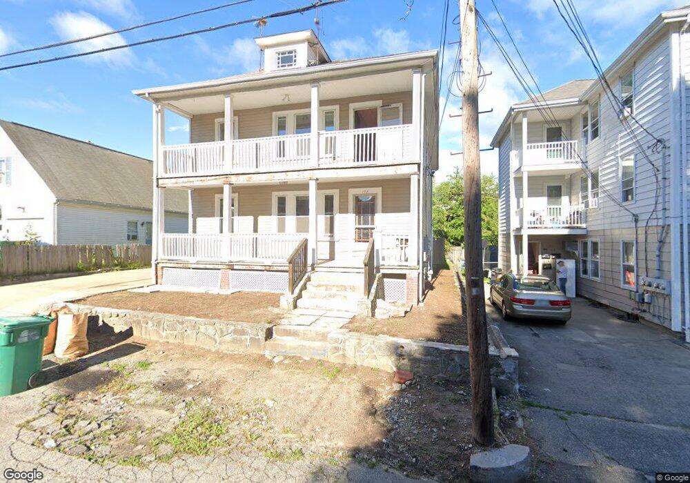
About This Home
This home is located at 192 Progresso Ave, Woonsocket, RI 02895 and is currently estimated at $457,923, approximately $199 per square foot. 192 Progresso Ave is a home located in Providence County with nearby schools including Woonsocket High School, Rise Prep Mayoral Academy Middle School, and Rise Prep Mayoral Academy.
Ownership History
We collect this data history from publicly available records. To have your information removed, we recommend requesting removal directly through your county’s website.
Purchase Details
Purchase Details
Purchase Details
Home Values in the Area
Average Home Value in this Area
Purchase History
We collect this data history from publicly available records. To have your information removed, we recommend requesting removal directly through your county’s website.
| Date | Buyer | Sale Price | Title Company |
|---|---|---|---|
| $103,000 | -- | ||
| $103,000 | -- | ||
| $110,000 | -- | ||
| $110,000 | -- | ||
| $128,000 | -- |
Mortgage History
We collect this data history from publicly available records. To have your information removed, we recommend requesting removal directly through your county’s website.
| Date | Status | Borrower | Loan Amount |
|---|---|---|---|
| Previous Owner | $243,000 | ||
| Previous Owner | $212,500 |
Tax History
We collect this data history from publicly available records. To have your information removed, we recommend requesting removal directly through your county’s website.
| Year | Tax Paid | Tax Assessment Tax Assessment Total Assessment is a certain percentage of the fair market value that is determined by local assessors to be the total taxable value of land and additions on the property. | Land | Improvement |
|---|---|---|---|---|
| 2025 | $4,610 | $410,500 | $87,900 | $322,600 |
| 2024 | $4,156 | $285,800 | $89,500 | $196,300 |
| 2023 | $3,995 | $285,800 | $89,500 | $196,300 |
| 2022 | $3,995 | $285,800 | $89,500 | $196,300 |
| 2021 | $3,190 | $134,300 | $35,600 | $98,700 |
| 2020 | $3,223 | $134,300 | $35,600 | $98,700 |
| 2018 | $3,234 | $134,300 | $35,600 | $98,700 |
| 2017 | $3,784 | $125,700 | $40,000 | $85,700 |
| 2016 | $4,002 | $125,700 | $40,000 | $85,700 |
| 2015 | $4,598 | $125,700 | $40,000 | $85,700 |
| 2014 | $4,431 | $123,300 | $44,000 | $79,300 |
Map
- 0 Robinson St
- 192 Dulude Ave
- 311 Elm St
- 685 Social St Unit 204
- 76 Sweet Ave
- 88 Mill St Unit 104
- 56 Mailloux St
- 628 Robinson St
- 752 Social St
- 736 Social St Unit 2R
- 96 Mill St Unit 303
- 51 Wood Ave
- 124 Saint Leon Ave
- 106 Mill St Unit 104
- 74 Henry St
- 114 Mill St Unit 303
- 114 Mill St Unit 101
- 285 Saint Louis Ave
- 227 Rathbun St
- 154 Saint Agnes Ave
- 198 Progresso Ave
- 180 Progresso Ave
- 170 Progresso Ave
- 351 Dulude Ave
- 210 Progresso Ave
- 179 Progresso Ave
- 365 Dulude Ave
- 183 Progresso Ave
- 337 Dulude Ave Unit 2F
- 337 Dulude Ave Unit 2R
- 337 Dulude Ave
- 181 Progresso Ave
- 158 Progresso Ave
- 327 Dulude Ave
- 325 Dulude Ave
- 391 Dulude Ave Unit 3
- 391 Dulude Ave Unit 2
- 153 Progresso Ave
- 374 Dulude Ave
- 378 Dulude Ave
Ask me questions while you tour the home.