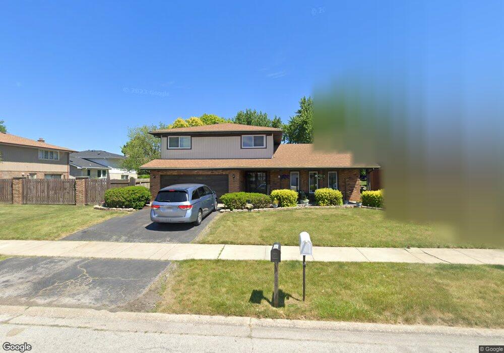
1920 E 172nd St South Holland, IL 60473
Estimated Value: $311,000 - $336,000
4
Beds
3
Baths
2,494
Sq Ft
$129/Sq Ft
Est. Value
About This Home
This home is located at 1920 E 172nd St, South Holland, IL 60473 and is currently estimated at $321,966, approximately $129 per square foot. 1920 E 172nd St is a home located in Cook County with nearby schools including Greenwood Elementary School, Mckinley Elementary School, and Mckinley Jr High School.
Ownership History
Date
Name
Owned For
Owner Type
Purchase Details
Closed on
Aug 25, 2017
Sold by
Chicago Title Land Trust Co
Bought by
Collier Anthony
Current Estimated Value
Home Financials for this Owner
Home Financials are based on the most recent Mortgage that was taken out on this home.
Original Mortgage
$153,332
Outstanding Balance
$127,805
Interest Rate
3.92%
Mortgage Type
VA
Estimated Equity
$194,161
Create a Home Valuation Report for This Property
The Home Valuation Report is an in-depth analysis detailing your home's value as well as a comparison with similar homes in the area
Home Values in the Area
Average Home Value in this Area
Purchase History
| Date | Buyer | Sale Price | Title Company |
|---|---|---|---|
| Collier Anthony | $155,000 | Chicago Title Land Trust Com |
Source: Public Records
Mortgage History
| Date | Status | Borrower | Loan Amount |
|---|---|---|---|
| Open | Collier Anthony | $153,332 |
Source: Public Records
Tax History Compared to Growth
Tax History
| Year | Tax Paid | Tax Assessment Tax Assessment Total Assessment is a certain percentage of the fair market value that is determined by local assessors to be the total taxable value of land and additions on the property. | Land | Improvement |
|---|---|---|---|---|
| 2024 | $10,890 | $27,001 | $5,935 | $21,066 |
| 2023 | $9,521 | $27,001 | $5,935 | $21,066 |
| 2022 | $9,521 | $19,553 | $5,125 | $14,428 |
| 2021 | $9,194 | $19,553 | $5,125 | $14,428 |
| 2020 | $8,793 | $19,553 | $5,125 | $14,428 |
| 2019 | $8,722 | $19,405 | $4,316 | $15,089 |
| 2018 | $8,324 | $19,405 | $4,316 | $15,089 |
| 2017 | $5,392 | $20,790 | $4,316 | $16,474 |
| 2016 | $6,614 | $18,493 | $4,046 | $14,447 |
| 2015 | $6,725 | $18,493 | $4,046 | $14,447 |
| 2014 | $7,462 | $18,493 | $4,046 | $14,447 |
| 2013 | $7,836 | $20,751 | $4,046 | $16,705 |
Source: Public Records
Map
Nearby Homes
- 17048 Clyde Ave
- 2024 E 171st Ct
- 1970 E 170th St
- 16909 Paxton Ave
- 2005 Fairview Ln
- 16822 Merrill Ave
- 2155 Bernice Rd
- 16747 Paxton Ave
- 2237 175th St Unit 1B
- 2237 175th St Unit 2B
- 2304 Holiday Terrace Unit 503
- 2306 Holiday Terrace Unit 149
- 2306 Holiday Terrace Unit 163
- 2306 Holiday Terrace Unit 146
- 2216 177th St
- 1320 E 169th Place
- 1991 Indiana Ave
- 2307 177th St
- 400 Park Ave Unit 118
- 400 Park Ave Unit 411
- 1926 E 172nd St
- 17151 Clyde Ave
- 1910 E 172nd St
- 17145 Clyde Ave
- 1932 E 172nd St
- 1919 E 171st Place
- 17139 Clyde Ave
- 1927 E 171st Place
- 1917 E 172nd St
- 1923 E 172nd St
- 1940 E 172nd St
- 1933 E 171st Place
- 1911 E 172nd St
- 1929 E 172nd St
- 1905 E 172nd St
- 1939 E 171st Place
- 1946 E 172nd St
- 17150 Clyde Ave
- 17156 Clyde Ave