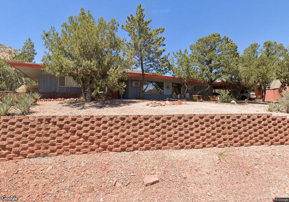
1920 Maxwell House Dr Sedona, AZ 86336
Estimated Value: $676,000 - $876,000
--
Bed
--
Bath
1,800
Sq Ft
$430/Sq Ft
Est. Value
About This Home
This home is located at 1920 Maxwell House Dr, Sedona, AZ 86336 and is currently estimated at $774,446, approximately $430 per square foot. 1920 Maxwell House Dr is a home located in Yavapai County with nearby schools including West Sedona Elementary School, Sedona Red Rock Junior/Senior High School, and Sedona Charter School.
Ownership History
Date
Name
Owned For
Owner Type
Purchase Details
Closed on
Feb 11, 2020
Sold by
Bollmann Dieter and Leffmann Merrill
Bought by
Leffmann Merrill
Current Estimated Value
Purchase Details
Closed on
May 22, 2012
Sold by
Flomerfelt Carol and Seymour Carol Flomerfelt
Bought by
Seymour Carol Flomerfelt and Seymour Carol
Purchase Details
Closed on
Apr 19, 1995
Sold by
Baker James David
Bought by
Baker Susan Abigal
Purchase Details
Closed on
Apr 12, 1995
Sold by
Molinari Carol
Bought by
Flomerfelt Carol
Create a Home Valuation Report for This Property
The Home Valuation Report is an in-depth analysis detailing your home's value as well as a comparison with similar homes in the area
Home Values in the Area
Average Home Value in this Area
Purchase History
| Date | Buyer | Sale Price | Title Company |
|---|---|---|---|
| Leffmann Merrill | -- | Pioneer Title Agency | |
| Leffmann Merrill | $440,000 | Pioneer Title Agency Inc | |
| Seymour Carol Flomerfelt | -- | None Available | |
| Baker Susan Abigal | $120,000 | -- | |
| Flomerfelt Carol | -- | -- |
Source: Public Records
Tax History Compared to Growth
Tax History
| Year | Tax Paid | Tax Assessment Tax Assessment Total Assessment is a certain percentage of the fair market value that is determined by local assessors to be the total taxable value of land and additions on the property. | Land | Improvement |
|---|---|---|---|---|
| 2026 | $2,951 | $58,723 | -- | -- |
| 2024 | $2,873 | $57,047 | -- | -- |
| 2023 | $2,873 | $41,754 | $13,349 | $28,405 |
| 2022 | $2,820 | $32,412 | $10,130 | $22,282 |
| 2021 | $2,866 | $30,858 | $9,133 | $21,725 |
| 2020 | $2,866 | $0 | $0 | $0 |
| 2019 | $2,839 | $0 | $0 | $0 |
| 2018 | $2,710 | $0 | $0 | $0 |
| 2017 | $2,637 | $0 | $0 | $0 |
| 2016 | $2,358 | $0 | $0 | $0 |
| 2015 | $2,254 | $0 | $0 | $0 |
| 2014 | $2,254 | $0 | $0 | $0 |
Source: Public Records
Map
Nearby Homes
- 55 Stations Dr W
- 747 Mountain Shadows Dr
- 460 Coffee Pot Dr
- 160 Budd Way
- 145 Grounds Dr
- 2190 Sanborn Dr
- 310 Mountain Shadows Dr Unit 89
- 2200 Buckboard Rd
- 260 Coffee Pot Dr Unit 17
- 260 Coffee Pot Dr Unit 6
- 260 Coffee Pot Dr Unit 20
- 25 Edgewood Cir
- 280 Goodrow Ln
- 30 Schimberg Rd
- 2310 Corral Rd
- 240 Goodrow Ln
- 1445 Cline Rd
- 40 Cliff View Ct
- 500 Sunshine Ln Unit 1
- 1670 W State Route 89a