
Seller's Agent in 2020
KATIE HUGHEY GATEWOOD
Hughey & Neuman, Inc.
(229) 881-0743
23 in this area
249 Total Sales
Estimated Value: $234,575 - $270,000
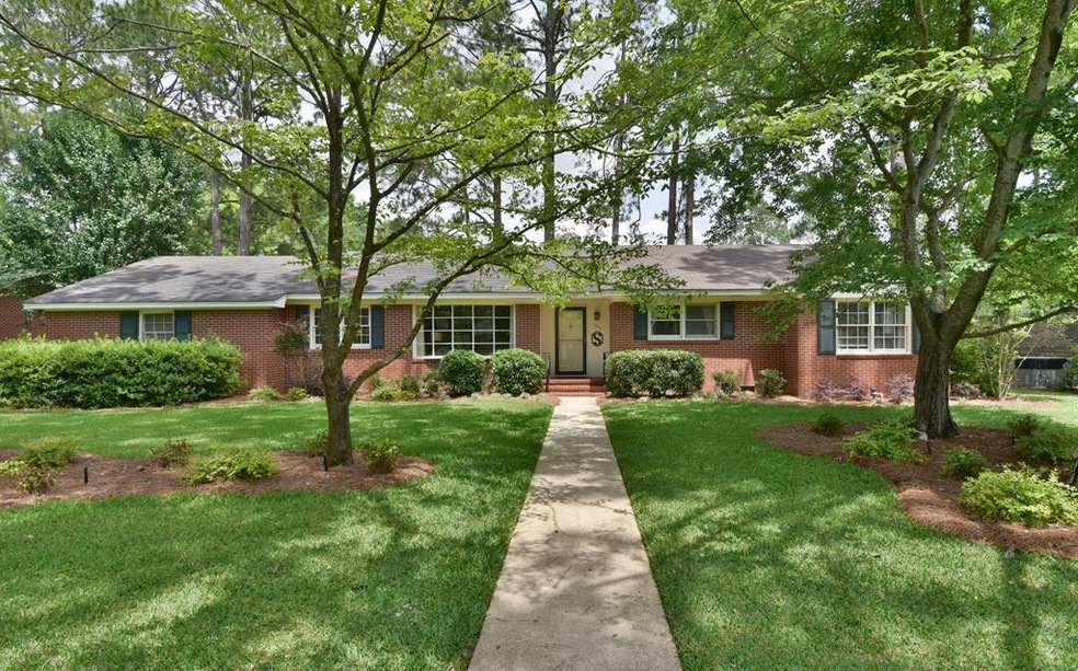
Welcome HOME! This NW Dougherty County, Lake Park Subdivision home is move-in ready! The current home owner has taken this house to another level and you will love all the custom details! Walk inside and you will immediately appreciate the renovated kitchen and open floor plan! The family room welcomes guest and features built-in bookshelves and beautiful bay window. The Kitchen features new soft-close cabinets, granite counter tops, subway back splash pantry, breakfast bar and updated stainless appliances! The Dining Room and Den/Office are spacious and feature beautiful refinished hardwood flooring,decorator colors and sweeping views of the screened in porch and backyard. (These rooms could easily be switched for a larger dining room) The hardwoods flow throughout the rest of the home and bedrooms. The current owners undertook a major renovation converting an extra bedroom in a luxury Master Suite featuring 2 closets, one being a large Walk-in, room for a King size bed and amazing custom on suite bath! Details include:new marble topped vanity, new tiled flooring, 6' stand-alone tub with subway tile surround and an Olympic style walk-in shower with basket weave marble flooring. WOW! The additional 2 bedrooms share a Hall bathroom (one bedroom has private access) completely updated with new vanity, granite counter tops,square sink, updated mirrors and lighting, all new stunning tile work, new faucet/fixtures and custom towel storage. The Bonus room is a show stopper! Located off the Laundry/Mud Room is a large enclosed room that doubles as a perfect family "Arrival Zone". Use this space for storage of all your gear, a playroom or a private home office! The potential is endless! +another large storage room! Other "can't miss" features include: 1) All new landscaping to really bring this home to life! Including pear trees and blackberry bushes! +Landscape & full yard irrigation 2) All new hardware, light switch covers T/O 3) R 30 insulation added 4) Updated Lighting 5) Large FULL Laundry Room with Storage Cabinets, Sink & Folding Table 6) Neutral Paint 7) Beautiful natural light throughout 8) Spacious Rear Screened porch 9) New Double carport 10)TONS of storage 11)Completely Fenced Yard with Rear Double gate alley access 12)Updated Thermostat 13)New storm door with rollable screen at front entrance 14) A short walk to area schools and convenient to all shopping, restaurants and churches! Don't delay.call a Realtor today!
Last Agent to Sell the Property
Hughey & Neuman, Inc. Brokerage Phone: 2294360212 License #278387 Listed on: 05/21/2020
| Date | Buyer | Sale Price | Title Company |
|---|---|---|---|
| Henderson Delaine | $174,750 | -- | |
| Smith Terry Daniel | $138,000 | -- | |
| Mattox Greg A | $109,000 | -- | |
| Evans Ruth Maye | -- | -- |
| Date | Status | Borrower | Loan Amount |
|---|---|---|---|
| Previous Owner | Smith Terry Daniel | $110,400 |
| Date | Event | Price | List to Sale | Price per Sq Ft | Prior Sale |
|---|---|---|---|---|---|
| 06/30/2020 06/30/20 | Sold | $174,750 | +26.6% | $73 / Sq Ft | |
| 05/21/2020 05/21/20 | Pending | -- | -- | -- | |
| 05/29/2015 05/29/15 | Sold | $138,000 | -- | $56 / Sq Ft | View Prior Sale |
| 04/26/2015 04/26/15 | Pending | -- | -- | -- |
| Year | Tax Paid | Tax Assessment Tax Assessment Total Assessment is a certain percentage of the fair market value that is determined by local assessors to be the total taxable value of land and additions on the property. | Land | Improvement |
|---|---|---|---|---|
| 2024 | $3,156 | $66,160 | $9,000 | $57,160 |
| 2023 | $3,082 | $66,160 | $9,000 | $57,160 |
| 2022 | $3,094 | $66,160 | $9,000 | $57,160 |
| 2021 | $2,868 | $66,160 | $9,000 | $57,160 |
| 2020 | $2,788 | $66,160 | $9,000 | $57,160 |
| 2019 | $2,799 | $66,160 | $9,000 | $57,160 |
| 2018 | $2,811 | $66,160 | $9,000 | $57,160 |
| 2017 | $2,213 | $66,160 | $9,000 | $57,160 |
| 2016 | $2,172 | $66,160 | $9,000 | $57,160 |
| 2015 | $2,627 | $66,160 | $9,000 | $57,160 |
| 2014 | $2,684 | $68,400 | $11,240 | $57,160 |
Seller's Agent in 2020
KATIE HUGHEY GATEWOOD
Hughey & Neuman, Inc.
(229) 881-0743
23 in this area
249 Total Sales
Buyer's Agent in 2020
Mary Linda Cotten
Coldwell Banker Walden & Kirkland
(229) 347-0953
11 in this area
218 Total Sales
Seller's Agent in 2015
Sharon Hughey
Hughey & Neuman, Inc.
(229) 881-3618
1 Total Sale
A
Buyer's Agent in 2015
Alice Jolley
Coldwell Banker Walden & Kirkland
Source: Albany Board of REALTORS®
MLS Number: 145203
APN: 0000P-00017-002