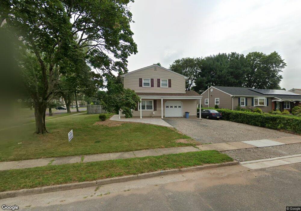
1922 Pershing Place South Plainfield, NJ 07080
Estimated Value: $442,031 - $616,000
3
Beds
2
Baths
--
Sq Ft
7,710
Sq Ft Lot
About This Home
This home is located at 1922 Pershing Place, South Plainfield, NJ 07080 and is currently estimated at $553,258. 1922 Pershing Place is a home located in Middlesex County with nearby schools including South Plainfield High School, The Queen City Academy Charter School, and Koinonia Academy.
Ownership History
Date
Name
Owned For
Owner Type
Purchase Details
Closed on
Jul 14, 2011
Sold by
Borsos Michael G and Borsos Tracey
Bought by
Borsos Tracey
Current Estimated Value
Purchase Details
Closed on
Mar 9, 1998
Sold by
Barylsky John
Bought by
Borsos Michael and Borsos Tracey
Home Financials for this Owner
Home Financials are based on the most recent Mortgage that was taken out on this home.
Original Mortgage
$120,000
Outstanding Balance
$21,701
Interest Rate
6.89%
Estimated Equity
$531,557
Purchase Details
Closed on
Apr 14, 1994
Sold by
Seymour Joann
Bought by
Barlyski John and Barlyski Marybeth
Create a Home Valuation Report for This Property
The Home Valuation Report is an in-depth analysis detailing your home's value as well as a comparison with similar homes in the area
Home Values in the Area
Average Home Value in this Area
Purchase History
| Date | Buyer | Sale Price | Title Company |
|---|---|---|---|
| Borsos Tracey | -- | Transnation Title Ins Co | |
| Borsos Michael | $150,000 | -- | |
| Barlyski John | $145,000 | -- |
Source: Public Records
Mortgage History
| Date | Status | Borrower | Loan Amount |
|---|---|---|---|
| Open | Borsos Michael | $120,000 |
Source: Public Records
Tax History Compared to Growth
Tax History
| Year | Tax Paid | Tax Assessment Tax Assessment Total Assessment is a certain percentage of the fair market value that is determined by local assessors to be the total taxable value of land and additions on the property. | Land | Improvement |
|---|---|---|---|---|
| 2025 | $7,457 | $106,800 | $29,600 | $77,200 |
| 2024 | $7,132 | $106,800 | $29,600 | $77,200 |
| 2023 | $7,132 | $106,800 | $29,600 | $77,200 |
| 2022 | $7,043 | $106,800 | $29,600 | $77,200 |
| 2021 | $6,878 | $106,800 | $29,600 | $77,200 |
| 2020 | $6,778 | $106,800 | $29,600 | $77,200 |
| 2019 | $6,503 | $106,800 | $29,600 | $77,200 |
| 2018 | $6,335 | $106,800 | $29,600 | $77,200 |
| 2017 | $6,254 | $106,800 | $29,600 | $77,200 |
| 2016 | $6,191 | $106,800 | $29,600 | $77,200 |
| 2015 | $6,084 | $106,800 | $29,600 | $77,200 |
| 2014 | $5,909 | $106,800 | $29,600 | $77,200 |
Source: Public Records
Map
Nearby Homes
- 551 Melrose Ave
- 1210 Maltby Ave
- 917 Tompkins Ave
- 1143 Worth Dr
- 105 Firth St
- 139 Palmer Ave
- 1453 Tooz Place
- 480 Sampton Ave
- 1221 Grant Ave Unit 23
- 1726 Kenyon Ave
- 241 Van Fleet Ave
- 1712 Kenyon Ave
- 131 Martin Dr
- 260 Merchants Ave
- 909 Sherman Ave
- 1210 Field Ave
- 1119 S 9th St
- 916 Sherman Ave
- 814 Sherman Ave Unit 18
- 1533 Clinton Ave
- 1920 Pershing Place
- 404 Franklin Ave
- 1937 Grant Ave
- 300 Franklin Ave
- 1918 Pershing Place
- 1921 Pershing Place
- 401 Franklin Ave
- 411 Franklin Ave
- 1933 Grant Ave
- 1919 Pershing Place
- 260 Franklin Ave
- 1916 Pershing Place
- 2007 Grant Ave
- 1952 Grant Ave
- 1952 Grant Ave Unit 952
- 311 Franklin Ave
- 1948 Grant Ave
- 1917 Pershing Place
- 1929 Grant Ave
- 503 Franklin Ave