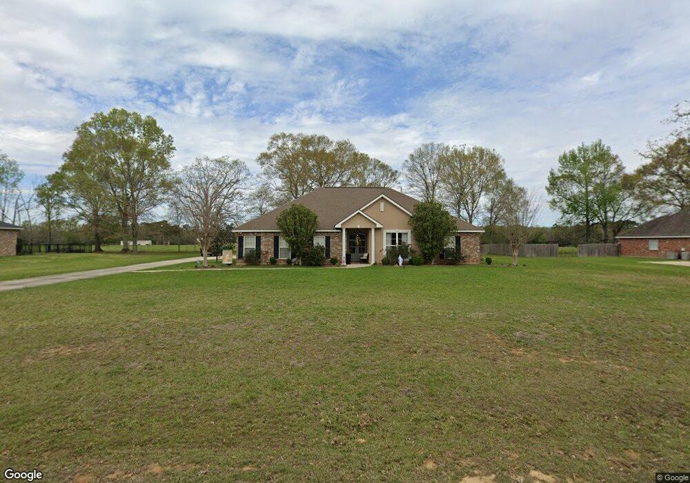
19239 Loranger Trace Loranger, LA 70446
Estimated Value: $280,925 - $365,000
Studio
--
Bath
3,144
Sq Ft
$98/Sq Ft
Est. Value
About This Home
This home is located at 19239 Loranger Trace, Loranger, LA 70446 and is currently estimated at $309,231, approximately $98 per square foot. 19239 Loranger Trace is a home located in Tangipahoa Parish with nearby schools including Loranger Elementary School, Loranger Middle School, and Loranger High School.
Ownership History
Date
Name
Owned For
Owner Type
Purchase Details
Closed on
Aug 30, 2006
Sold by
Baham Margaret Hemphill and Baham Michael Ancel
Bought by
Genco Ronald Leonard and Genco Lisa Marie Mclain
Current Estimated Value
Home Financials for this Owner
Home Financials are based on the most recent Mortgage that was taken out on this home.
Original Mortgage
$252,000
Outstanding Balance
$147,144
Interest Rate
6.64%
Mortgage Type
Future Advance Clause Open End Mortgage
Estimated Equity
$162,087
Create a Home Valuation Report for This Property
The Home Valuation Report is an in-depth analysis detailing your home's value as well as a comparison with similar homes in the area
Purchase History
| Date | Buyer | Sale Price | Title Company |
|---|---|---|---|
| Genco Ronald Leonard | $50,000 | None Available |
Source: Public Records
Mortgage History
| Date | Status | Borrower | Loan Amount |
|---|---|---|---|
| Open | Genco Ronald Leonard | $252,000 |
Source: Public Records
Tax History
| Year | Tax Paid | Tax Assessment Tax Assessment Total Assessment is a certain percentage of the fair market value that is determined by local assessors to be the total taxable value of land and additions on the property. | Land | Improvement |
|---|---|---|---|---|
| 2025 | $1,913 | $26,525 | $3,780 | $22,745 |
| 2024 | $1,902 | $26,525 | $3,780 | $22,745 |
| 2023 | $1,910 | $26,477 | $3,500 | $22,977 |
| 2022 | $1,910 | $26,477 | $3,500 | $22,977 |
| 2021 | $1,375 | $26,477 | $3,500 | $22,977 |
| 2020 | $1,910 | $26,477 | $3,500 | $22,977 |
| 2019 | $1,911 | $26,477 | $3,500 | $22,977 |
| 2018 | $1,911 | $26,477 | $3,500 | $22,977 |
| 2017 | $1,911 | $26,477 | $3,500 | $22,977 |
| 2016 | $253 | $3,500 | $3,500 | $0 |
| 2015 | $254 | $3,500 | $3,500 | $0 |
| 2014 | $253 | $3,500 | $3,500 | $0 |
Source: Public Records
Map
Nearby Homes
- 53361 Caitlyns Way
- 53361 Caitlyn`s Way None
- 53511 Harvest Ln
- 54120 Passman Rd
- 54225 Passman Rd
- 53384 N Highway 40 Hwy
- 54198 Straughan Nursery Rd
- Hwy 40 E Unit LotWP001
- 19282 Deerfield Loop
- 19440 Deerfield Loop
- 19491 Deerfield Loop None
- 52254 Puls Ct
- 52056 Husser Ln
- 18190 Wolf Track Way
- 18178 Grey Wolf Trail
- 55021 Coyote Den Way
- 55154 Coyote Den Way
- 18382 Red Wolf Trail
- 18188 Red Wolf Trail
- 19257 Loranger Trace
- 19223 Loranger Trace
- 19240 Loranger Trace
- 19207 Loranger Trace
- 19275 Loranger Trace
- 19275 Loranger Trace None
- 0 Phillips Other Unit 2344331
- 0 Phillip's Path None
- 0 Phillips Path None
- 0 Caitlyn's Way Unit 803900
- 0 Caitlyn's Way Unit 981400
- 0 Caitlyn's Way Unit 2237343
- 19274 Loranger Trace
- 0 Phillip's Other Unit 2237345
- 53358 Phillips Path
- 53358 Phillips Path Other
- 53358 Phillips Other
- 53358 Phillips Path None
- 19191 Loranger Trace
- 70403 Phillips Path
Your Personal Tour Guide
Ask me questions while you tour the home.