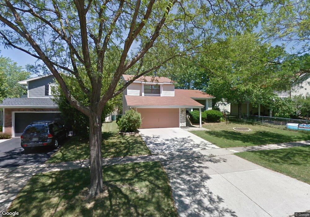
1924 Brookside Ln Hoffman Estates, IL 60169
South Hoffman Estates NeighborhoodEstimated Value: $380,698 - $421,000
3
Beds
2
Baths
1,586
Sq Ft
$255/Sq Ft
Est. Value
About This Home
This home is located at 1924 Brookside Ln, Hoffman Estates, IL 60169 and is currently estimated at $404,675, approximately $255 per square foot. 1924 Brookside Ln is a home located in Cook County with nearby schools including Neil Armstrong Elementary School, Dwight D Eisenhower Junior High School, and Hoffman Estates High School.
Ownership History
Date
Name
Owned For
Owner Type
Purchase Details
Closed on
May 25, 1994
Sold by
Sloan Todd A and Sloan Joan H
Bought by
Kawata Tamotsu and Kawata Seiko
Current Estimated Value
Home Financials for this Owner
Home Financials are based on the most recent Mortgage that was taken out on this home.
Original Mortgage
$109,800
Interest Rate
7.25%
Create a Home Valuation Report for This Property
The Home Valuation Report is an in-depth analysis detailing your home's value as well as a comparison with similar homes in the area
Home Values in the Area
Average Home Value in this Area
Purchase History
| Date | Buyer | Sale Price | Title Company |
|---|---|---|---|
| Kawata Tamotsu | $137,500 | -- |
Source: Public Records
Mortgage History
| Date | Status | Borrower | Loan Amount |
|---|---|---|---|
| Closed | Kawata Tamotsu | $109,800 |
Source: Public Records
Tax History
| Year | Tax Paid | Tax Assessment Tax Assessment Total Assessment is a certain percentage of the fair market value that is determined by local assessors to be the total taxable value of land and additions on the property. | Land | Improvement |
|---|---|---|---|---|
| 2025 | $6,454 | $35,000 | $5,049 | $29,951 |
| 2024 | $6,454 | $27,000 | $4,590 | $22,410 |
| 2023 | $7,003 | $27,000 | $4,590 | $22,410 |
| 2022 | $7,003 | $27,000 | $4,590 | $22,410 |
| 2021 | $5,717 | $20,393 | $7,229 | $13,164 |
| 2020 | $6,573 | $23,191 | $7,229 | $15,962 |
| 2019 | $6,540 | $25,768 | $7,229 | $18,539 |
| 2018 | $6,324 | $22,830 | $6,311 | $16,519 |
| 2017 | $6,231 | $22,830 | $6,311 | $16,519 |
| 2016 | $6,058 | $22,830 | $6,311 | $16,519 |
| 2015 | $5,542 | $19,877 | $5,508 | $14,369 |
| 2014 | $5,461 | $19,877 | $5,508 | $14,369 |
| 2013 | $5,561 | $20,717 | $5,508 | $15,209 |
Source: Public Records
Map
Nearby Homes
- 1587 Brookside Dr
- 1880 Bonnie Ln Unit 416
- 1612 Islandview Ct
- 1659 Islandview Ct
- 1769 Sessions Walk Unit C
- 1724 Fayette Walk Unit J
- 1712 Fayette Walk Unit D
- 1975 Windsong Dr Unit 333E1
- 2021 Kensington Ln Unit 3004
- 2027 Kensington Ln Unit 3001
- 2025 Kensington Ln Unit 3002
- 2023 Kensington Ln Unit 3003
- 1026 Denham Place Unit 1
- 1933 Williamsburg Dr Unit 1
- 1975 Leiter Way Unit 12002
- 1982 Leiter Way Unit 13004
- 1985 Leiter Way Unit 1102
- 1988 Leiter Way Unit 13001
- 1979 Leiter Way Unit 12004
- 1981 Leiter Way Unit 12005
- 1934 Brookside Ln
- 1904 Brookside Ln
- 1589 Brookside Dr
- 1591 Brookside Dr
- 1944 Brookside Ln
- 1902 Brookside Ln
- 1921 Brookside Ln Unit 4
- 1925 Brookside Ln
- 1900 Brookside Ln
- 1593 Brookside Dr
- 1935 Brookside Ln
- 1919 Brookside Ln Unit 4
- 1907 Brookside Ln
- 1945 Brookside Ln
- 1585 Brookside Dr
- 1964 Brookside Ln
- 1905 Brookside Ln
- 1909 Brookside Ln
- 1903 Brookside Ln
- 1911 Brookside Ln
Your Personal Tour Guide
Ask me questions while you tour the home.