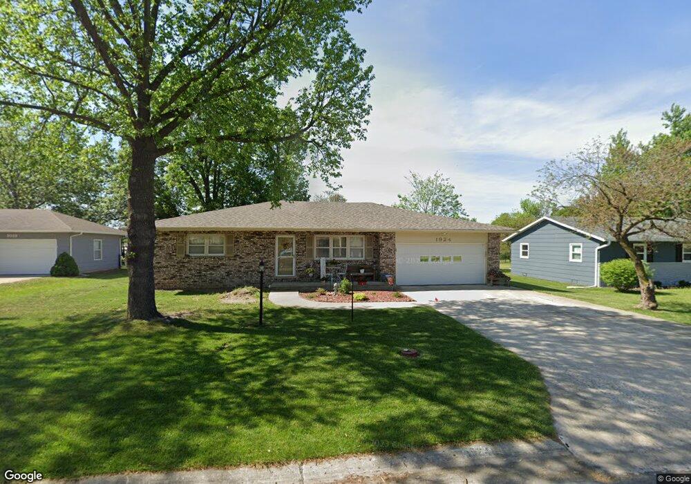
1924 Eastbrook Cir Moberly, MO 65270
Estimated Value: $216,000 - $262,000
3
Beds
3
Baths
2,143
Sq Ft
$112/Sq Ft
Est. Value
About This Home
This home is located at 1924 Eastbrook Cir, Moberly, MO 65270 and is currently estimated at $240,695, approximately $112 per square foot. 1924 Eastbrook Cir is a home located in Randolph County with nearby schools including Moberly Senior High School and Maranatha Seventh-day Adventist School.
Ownership History
Date
Name
Owned For
Owner Type
Purchase Details
Closed on
Nov 2, 2010
Sold by
Hansen Wayne R and Hansen Christine O
Bought by
Harris John David and Harris Janice Kay
Current Estimated Value
Home Financials for this Owner
Home Financials are based on the most recent Mortgage that was taken out on this home.
Original Mortgage
$120,000
Outstanding Balance
$79,174
Interest Rate
4.27%
Estimated Equity
$161,521
Purchase Details
Closed on
Jul 15, 2009
Sold by
Wiesner Joseph E and Wiesner Elaine M
Bought by
Hansen Wayne R and Hansen Christine O
Home Financials for this Owner
Home Financials are based on the most recent Mortgage that was taken out on this home.
Original Mortgage
$120,000
Interest Rate
5.41%
Mortgage Type
Future Advance Clause Open End Mortgage
Create a Home Valuation Report for This Property
The Home Valuation Report is an in-depth analysis detailing your home's value as well as a comparison with similar homes in the area
Home Values in the Area
Average Home Value in this Area
Purchase History
| Date | Buyer | Sale Price | Title Company |
|---|---|---|---|
| Harris John David | $150,000 | -- | |
| Hansen Wayne R | -- | -- |
Source: Public Records
Mortgage History
| Date | Status | Borrower | Loan Amount |
|---|---|---|---|
| Open | Harris John David | $120,000 | |
| Previous Owner | Hansen Wayne R | $120,000 |
Source: Public Records
Tax History Compared to Growth
Tax History
| Year | Tax Paid | Tax Assessment Tax Assessment Total Assessment is a certain percentage of the fair market value that is determined by local assessors to be the total taxable value of land and additions on the property. | Land | Improvement |
|---|---|---|---|---|
| 2025 | $2,086 | $30,740 | $3,270 | $27,470 |
| 2024 | $2,086 | $28,640 | $2,850 | $25,790 |
| 2023 | $2,117 | $28,640 | $2,850 | $25,790 |
| 2022 | $2,094 | $29,080 | $2,850 | $26,230 |
| 2021 | $2,093 | $29,080 | $2,850 | $26,230 |
| 2020 | $2,093 | $29,080 | $2,850 | $26,230 |
| 2019 | $2,088 | $29,080 | $2,850 | $26,230 |
| 2018 | $2,218 | $30,980 | $2,850 | $28,130 |
| 2017 | $2,213 | $30,980 | $0 | $0 |
| 2016 | $2,108 | $29,670 | $0 | $0 |
| 2014 | -- | $27,360 | $0 | $0 |
| 2013 | -- | $27,360 | $0 | $0 |
| 2012 | -- | $25,160 | $0 | $0 |
Source: Public Records
Map
Nearby Homes
- 1410 Hulen Dr
- 606 Weintz St
- 718 E Logan St
- 428 Woodland Ave
- 509 Cleveland Ave
- 818 Vincil St
- 319 Halleck St
- 524 Barrow St
- 531 Farror St
- 208 Wisdom St
- 602 Vincil St
- 614 Union Ave
- 2003 County Road 1740
- 511 Union Ave
- 101 N Ault St
- 517 S Clark St
- 720 Saint Charles St
- 1000 S Williams St
- 619 Madison Ave
- 1216 Shepherds Dr
- 1918 Eastbrook Cir
- 1930 Eastbrook Cir
- 600 Mckinsey Place
- 1912 Eastbrook Cir
- 1919 Eastbrook Cir
- 1913 Eastbrook Cir
- 1925 Eastbrook Cir
- 1907 Eastbrook Cir
- 1906 Eastbrook Cir
- 605 Mckinsey Place
- 1931 Eastbrook Cir
- 606 Mckinsey Place
- 1942 Eastbrook Cir
- 1937 Eastbrook Cir
- 1901 Eastbrook Cir
- 1948 Eastbrook Cir
- 1632 Prairie Ln
- 1638 Prairie Ln
- 1626 Prairie Ln
- 1644 Prairie Ln