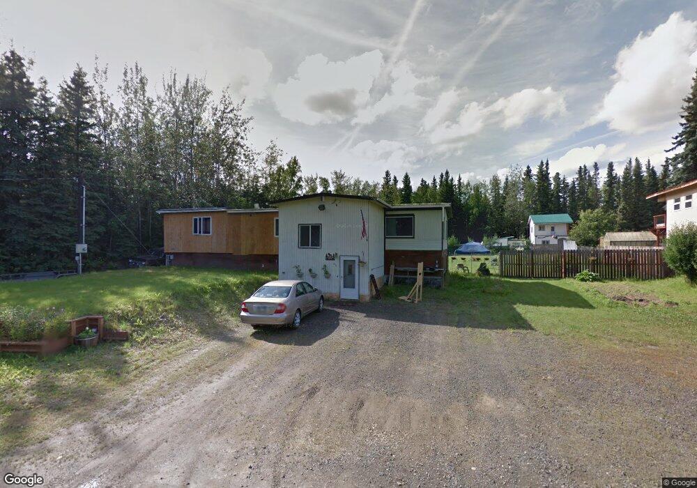
1924 Loose Moose Loop North Pole, AK 99705
Badger NeighborhoodEstimated Value: $177,000 - $305,000
--
Bed
2
Baths
1,512
Sq Ft
$161/Sq Ft
Est. Value
About This Home
This home is located at 1924 Loose Moose Loop, North Pole, AK 99705 and is currently estimated at $243,379, approximately $160 per square foot. 1924 Loose Moose Loop is a home located in Fairbanks North Star Borough with nearby schools including Ticasuk Brown Elementary School, North Pole Middle School, and North Pole High School.
Ownership History
Date
Name
Owned For
Owner Type
Purchase Details
Closed on
Nov 21, 2003
Sold by
Leroux Michael S
Bought by
Leroux Michael S and Leroux Tami M
Current Estimated Value
Purchase Details
Closed on
May 28, 2003
Sold by
Wilson Kory J and Wilson Kimberly M
Bought by
Leroux Michael S
Home Financials for this Owner
Home Financials are based on the most recent Mortgage that was taken out on this home.
Original Mortgage
$103,097
Outstanding Balance
$45,063
Interest Rate
5.75%
Mortgage Type
Unknown
Estimated Equity
$198,316
Create a Home Valuation Report for This Property
The Home Valuation Report is an in-depth analysis detailing your home's value as well as a comparison with similar homes in the area
Home Values in the Area
Average Home Value in this Area
Purchase History
| Date | Buyer | Sale Price | Title Company |
|---|---|---|---|
| Leroux Michael S | -- | -- | |
| Leroux Michael S | -- | -- |
Source: Public Records
Mortgage History
| Date | Status | Borrower | Loan Amount |
|---|---|---|---|
| Open | Leroux Michael S | $103,097 |
Source: Public Records
Tax History Compared to Growth
Tax History
| Year | Tax Paid | Tax Assessment Tax Assessment Total Assessment is a certain percentage of the fair market value that is determined by local assessors to be the total taxable value of land and additions on the property. | Land | Improvement |
|---|---|---|---|---|
| 2025 | $2,914 | $192,580 | $8,178 | $184,402 |
| 2024 | $2,823 | $187,145 | $8,178 | $178,967 |
| 2023 | $2,683 | $179,650 | $8,178 | $171,472 |
| 2022 | $2,823 | $168,301 | $8,178 | $160,123 |
| 2021 | $3,079 | $166,114 | $8,178 | $157,936 |
| 2020 | $3,010 | $160,421 | $8,178 | $152,243 |
| 2019 | $2,892 | $155,016 | $8,178 | $146,838 |
| 2018 | $2,716 | $155,884 | $8,178 | $147,706 |
| 2017 | $2,469 | $150,869 | $8,178 | $142,691 |
| 2016 | $2,325 | $146,112 | $8,178 | $137,934 |
| 2015 | $2,047 | $143,408 | $8,178 | $135,230 |
| 2014 | $2,047 | $143,408 | $8,178 | $135,230 |
Source: Public Records
Map
Nearby Homes
- 2011 Kendall Ave
- 1992 Badger Rd Unit 1994 Badger Rd
- 453 Pleasure Dr
- 1118 Williams Rd
- 2020 Haydon Ct
- 1157 Acorn Cir
- 1444 Tramon Ave
- 1200 Lakloey Dr
- 1370 Toolik Dr
- 2432 Whitman Rd
- 1316 Cordelia Way
- 1783 Bradway Rd
- NHN Heartland Ave
- L4 Heartland Ave
- 895 Lakloey Dr
- 1300 Becky St
- Lot 33 Maude Boyle Dr
- Lot 35 Maude Boyle Dr
- Lot 38 Maude Boyle Dr Unit The River`s Edge Est
- Lot 37 Maude Boyle Dr Unit The River`s Edge Est
- 1938 Loose Moose Loop
- 1956 Loose Moose Loop
- 1898 Loose Moose Loop
- 1894 Loose Moose Loop
- 1902 Loose Moose Loop
- 1964 Loose Moose Loop
- 1939 Loose Moose Loop
- 1925 Loose Moose Loop
- 1935 Loose Moose Loop
- 1888 Loose Moose Loop
- 1951 Loose Moose Loop
- 1941 Loose Moose Loop
- 1909 Loose Moose Loop
- 1880 Loose Moose Loop
- 1967 Loose Moose Loop
- 1840 Badger Rd
- 1971 Loose Moose Loop
- 1883 Loose Moose Loop
- 1852 Badger Rd
- 786 Landing Rd