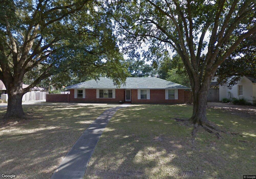
1924 Pollard Pkwy Baton Rouge, LA 70808
Highlands/Perkins NeighborhoodEstimated Value: $377,903 - $426,000
--
Bed
--
Bath
2,284
Sq Ft
$172/Sq Ft
Est. Value
About This Home
This home is located at 1924 Pollard Pkwy, Baton Rouge, LA 70808 and is currently estimated at $393,226, approximately $172 per square foot. 1924 Pollard Pkwy is a home located in East Baton Rouge Parish with nearby schools including Westminster Elementary School, Glasgow Middle School, and Tara High School.
Ownership History
Date
Name
Owned For
Owner Type
Purchase Details
Closed on
May 11, 1999
Sold by
West Stirling Jr William M and West Stirling Louis
Bought by
Guillory Stirling Iii William Mumford and Guillory Stirling Mary Beth
Current Estimated Value
Home Financials for this Owner
Home Financials are based on the most recent Mortgage that was taken out on this home.
Original Mortgage
$108,000
Outstanding Balance
$27,905
Interest Rate
7.04%
Estimated Equity
$365,321
Create a Home Valuation Report for This Property
The Home Valuation Report is an in-depth analysis detailing your home's value as well as a comparison with similar homes in the area
Home Values in the Area
Average Home Value in this Area
Purchase History
| Date | Buyer | Sale Price | Title Company |
|---|---|---|---|
| Guillory Stirling Iii William Mumford | $135,000 | -- |
Source: Public Records
Mortgage History
| Date | Status | Borrower | Loan Amount |
|---|---|---|---|
| Open | Guillory Stirling Iii William Mumford | $108,000 |
Source: Public Records
Tax History Compared to Growth
Tax History
| Year | Tax Paid | Tax Assessment Tax Assessment Total Assessment is a certain percentage of the fair market value that is determined by local assessors to be the total taxable value of land and additions on the property. | Land | Improvement |
|---|---|---|---|---|
| 2024 | $2,421 | $27,410 | $6,000 | $21,410 |
| 2023 | $2,421 | $27,410 | $6,000 | $21,410 |
| 2022 | $3,273 | $27,410 | $6,000 | $21,410 |
| 2021 | $3,198 | $27,410 | $6,000 | $21,410 |
| 2020 | $3,177 | $27,410 | $6,000 | $21,410 |
| 2019 | $3,058 | $25,250 | $6,000 | $19,250 |
| 2018 | $3,020 | $25,250 | $6,000 | $19,250 |
| 2017 | $3,020 | $25,250 | $6,000 | $19,250 |
| 2016 | $2,167 | $25,250 | $6,000 | $19,250 |
| 2015 | $1,762 | $21,750 | $6,000 | $15,750 |
| 2014 | $1,465 | $19,250 | $6,000 | $13,250 |
| 2013 | -- | $19,250 | $6,000 | $13,250 |
Source: Public Records
Map
Nearby Homes
- 5755 Hyacinth Ave
- 5889 Hyacinth Ave
- 1662 Pollard Pkwy
- 86 Stokes Ct
- 2006 Deaux Parc Dr
- 6061 Hibiscus Dr
- 5341 Mimosa St
- 5977 Hyacinth Ave
- 1812 Ville Marie St
- 1752 Ville Marie St
- 19 Adrienne Way
- 10 Adrienne
- 13 Adrienne Way
- 15 Adrienne Way
- 4 Adrienne
- 1 Adrienne Way
- 12 Adrienne
- 3 Adrienne Way
- 1738 Rouzan Ave
- 9 Adrienne
- 1906 Pollard Pkwy
- 1946 Pollard Pkwy
- 1965 Columbine St
- 1987 Columbine St
- 1945 N Columbine
- 1933 Pollard Pkwy
- 1868 Pollard Pkwy
- 1945 Columbine St
- 1905 Pollard Pkwy
- 1905 Pollard Pkwy
- 1964 Pollard Pkwy
- 2027 Columbine St
- 1945 Pollard Pkwy
- 1875 Pollard Pkwy
- 1925 Columbine St
- 2049 Columbine St
- 1852 Pollard Pkwy
- 2020 Pollard Pkwy
- 1855 Pollard Pkwy
- 1984 Columbine St