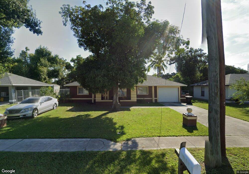
1925 Velasco St Fort Myers, FL 33916
East Fort Myers NeighborhoodEstimated Value: $280,369 - $343,000
6
Beds
3
Baths
1,673
Sq Ft
$178/Sq Ft
Est. Value
About This Home
This home is located at 1925 Velasco St, Fort Myers, FL 33916 and is currently estimated at $298,092, approximately $178 per square foot. 1925 Velasco St is a home located in Lee County with nearby schools including Edison Park Creative & Expressive Arts School, Allen Park Elementary School, and Orangewood Elementary School.
Ownership History
Date
Name
Owned For
Owner Type
Purchase Details
Closed on
Jun 14, 2002
Sold by
Peterson Major and Peterson Letha Mae
Bought by
Peterson Major
Current Estimated Value
Purchase Details
Closed on
Jan 14, 1994
Sold by
Dunbar Ind Action Dev Inc
Bought by
Peterson Major and Peterson Letha Mae
Home Financials for this Owner
Home Financials are based on the most recent Mortgage that was taken out on this home.
Original Mortgage
$25,000
Interest Rate
7.13%
Create a Home Valuation Report for This Property
The Home Valuation Report is an in-depth analysis detailing your home's value as well as a comparison with similar homes in the area
Home Values in the Area
Average Home Value in this Area
Purchase History
| Date | Buyer | Sale Price | Title Company |
|---|---|---|---|
| Peterson Major | $11,000 | -- | |
| Peterson Major | $52,000 | -- |
Source: Public Records
Mortgage History
| Date | Status | Borrower | Loan Amount |
|---|---|---|---|
| Previous Owner | Peterson Major | $25,000 |
Source: Public Records
Tax History Compared to Growth
Tax History
| Year | Tax Paid | Tax Assessment Tax Assessment Total Assessment is a certain percentage of the fair market value that is determined by local assessors to be the total taxable value of land and additions on the property. | Land | Improvement |
|---|---|---|---|---|
| 2025 | $995 | $48,863 | -- | -- |
| 2024 | $951 | $47,486 | -- | -- |
| 2023 | $951 | $46,103 | $0 | $0 |
| 2022 | $943 | $44,760 | $0 | $0 |
| 2021 | $914 | $136,612 | $3,700 | $132,912 |
| 2020 | $801 | $42,856 | $0 | $0 |
| 2019 | $778 | $41,892 | $0 | $0 |
| 2018 | $770 | $41,111 | $0 | $0 |
| 2017 | $738 | $40,265 | $0 | $0 |
| 2016 | $706 | $68,527 | $3,700 | $64,827 |
| 2015 | $702 | $61,205 | $3,225 | $57,980 |
| 2014 | $600 | $49,806 | $3,225 | $46,581 |
| 2013 | -- | $48,899 | $4,000 | $44,899 |
Source: Public Records
Map
Nearby Homes
- 1948 Lillie St
- 1938 Lillie St
- 1861 Lillie St
- 1905 Knight St
- 1958 Knight St
- 2992 Douglas Ave
- 2849 Price Ave
- 2965 Lincoln Blvd
- 2748 Orange St
- 2012 Wright St
- 2984 Lincoln Blvd
- 2032-2040 Wright St
- 2726 Dr Martin Luther King Blvd N
- 2924 Dunbar St
- 0 Cranford Ave
- 3043 Dunbar Ave
- 2810 Dunbar Ave
- 3147 Economy St
- 2661 Market St
- 2656 Lime St