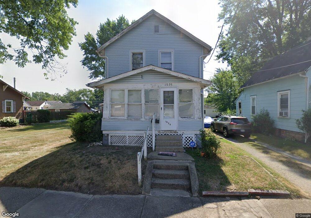
1926 Taft Ave NE Canton, OH 44705
Fairmount NeighborhoodEstimated Value: $75,000 - $98,000
2
Beds
1
Bath
1,020
Sq Ft
$84/Sq Ft
Est. Value
About This Home
This home is located at 1926 Taft Ave NE, Canton, OH 44705 and is currently estimated at $85,899, approximately $84 per square foot. 1926 Taft Ave NE is a home located in Stark County with nearby schools including Belle Stone Elementary School, Early Learning Center @ Schreiber, and Youtz Intermediate School.
Ownership History
Date
Name
Owned For
Owner Type
Purchase Details
Closed on
Jul 16, 2021
Sold by
Frazier Elizabeth W
Bought by
Wofford Lillie Mae and Frazier Elizabeth W
Current Estimated Value
Purchase Details
Closed on
May 5, 1993
Purchase Details
Closed on
May 28, 1992
Purchase Details
Closed on
Mar 26, 1992
Purchase Details
Closed on
Apr 21, 1989
Create a Home Valuation Report for This Property
The Home Valuation Report is an in-depth analysis detailing your home's value as well as a comparison with similar homes in the area
Home Values in the Area
Average Home Value in this Area
Purchase History
| Date | Buyer | Sale Price | Title Company |
|---|---|---|---|
| Wofford Lillie Mae | -- | None Available | |
| -- | $31,500 | -- | |
| -- | $19,000 | -- | |
| -- | $20,000 | -- | |
| -- | $28,900 | -- |
Source: Public Records
Tax History Compared to Growth
Tax History
| Year | Tax Paid | Tax Assessment Tax Assessment Total Assessment is a certain percentage of the fair market value that is determined by local assessors to be the total taxable value of land and additions on the property. | Land | Improvement |
|---|---|---|---|---|
| 2025 | -- | $20,200 | $3,120 | $17,080 |
| 2024 | -- | $20,200 | $3,120 | $17,080 |
| 2023 | $654 | $10,920 | $2,310 | $8,610 |
| 2022 | $638 | $10,920 | $2,310 | $8,610 |
| 2021 | $133 | $10,920 | $2,310 | $8,610 |
| 2020 | $6 | $8,440 | $1,930 | $6,510 |
| 2019 | $6 | $8,440 | $1,930 | $6,510 |
| 2018 | $489 | $8,440 | $1,930 | $6,510 |
| 2017 | $506 | $7,950 | $2,070 | $5,880 |
| 2016 | $508 | $7,950 | $2,070 | $5,880 |
| 2015 | $511 | $7,950 | $2,070 | $5,880 |
| 2014 | $572 | $8,370 | $2,170 | $6,200 |
| 2013 | $277 | $8,370 | $2,170 | $6,200 |
Source: Public Records
Map
Nearby Homes
- 2314 24th St NE
- 1742 Taft Ave NE
- 2211 17th St NE
- 2107 Harrisburg Rd NE
- 2216 17th St NE
- 1636 Superior Ave NE
- 2526 17th St NE
- 2611 Indiana Way NE
- 2715 19th St NE
- 2323 15th St NE
- 1524 Harrisburg Rd NE
- 1457 Edwards Ave NE
- 2100 Maple Ave NE
- 2015 Maple Ave NE
- 2310 Maple Ave NE
- 2400 Winfield Way NE
- 2017 28th St NE
- 1815 Virginia Place NE
- 1638 Warrick Place NE
- 1610 Colonial Blvd NE
- 1920 Taft Ave NE
- 1932 Taft Ave NE
- 1918 Taft Ave NE
- 2348 20th St NE
- 1921 Superior Ave NE
- 1925 Taft Ave NE
- 1908 Taft Ave NE
- 1931 Taft Ave NE
- 1919 Taft Ave NE
- 1904 Taft Ave NE
- 2337 20th St NE
- 1909 Superior Ave NE
- 2333 20th St NE
- 2343 20th St NE
- 2329 20th St NE
- 2347 20th St NE
- 2323 20th St NE
- 2327 20th St NE
- 1905 Superior Ave NE
- 1901 Taft Ave NE