Estimated Value: $353,000 - $386,000
4
Beds
3
Baths
2,243
Sq Ft
$165/Sq Ft
Est. Value
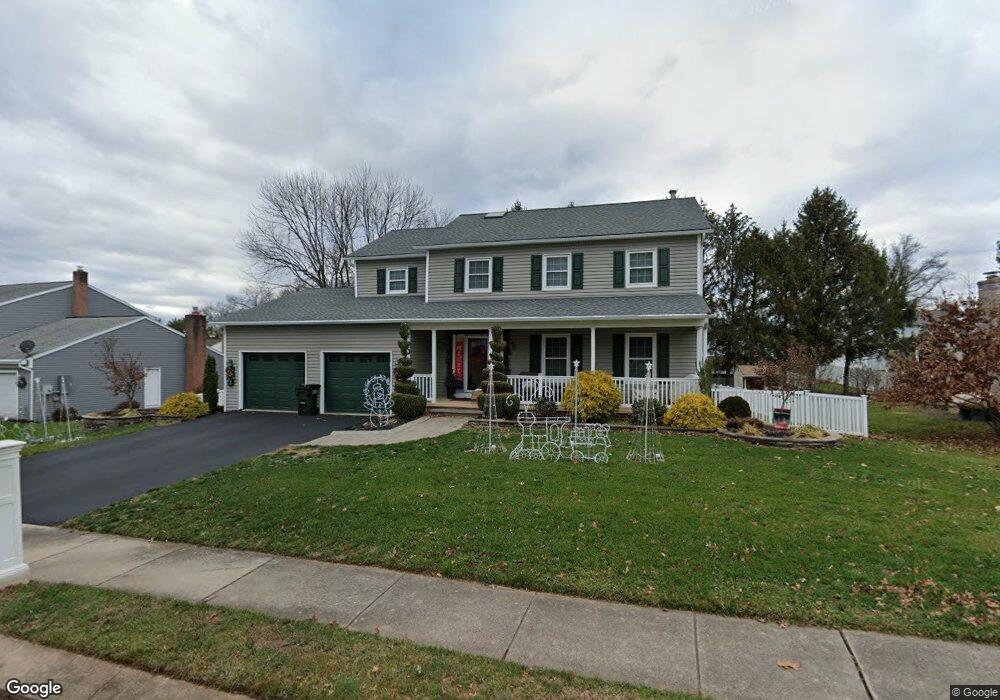
About This Home
This home is located at 1927 Bretton Ln, York, PA 17408 and is currently estimated at $370,538, approximately $165 per square foot. 1927 Bretton Ln is a home located in York County with nearby schools including West York Area High School, Christian School of York, and Keystone Christian Academy - York.
Ownership History
Date
Name
Owned For
Owner Type
Purchase Details
Closed on
Jul 16, 2021
Sold by
Somers Lori M and Somers Tom D
Bought by
Somers Lori M
Current Estimated Value
Home Financials for this Owner
Home Financials are based on the most recent Mortgage that was taken out on this home.
Original Mortgage
$170,000
Outstanding Balance
$130,068
Interest Rate
2.96%
Mortgage Type
New Conventional
Estimated Equity
$240,470
Purchase Details
Closed on
Jun 15, 2003
Sold by
Mahalingam Subramaniam and Mahalingam Kowsaly
Bought by
Somers Tom D and Somers Lori M
Home Financials for this Owner
Home Financials are based on the most recent Mortgage that was taken out on this home.
Original Mortgage
$199,900
Interest Rate
6.12%
Mortgage Type
Purchase Money Mortgage
Purchase Details
Closed on
Nov 14, 1988
Bought by
Somers Tom D and Somers Lori M
Create a Home Valuation Report for This Property
The Home Valuation Report is an in-depth analysis detailing your home's value as well as a comparison with similar homes in the area
Home Values in the Area
Average Home Value in this Area
Purchase History
| Date | Buyer | Sale Price | Title Company |
|---|---|---|---|
| Somers Lori M | -- | Cu Abstract | |
| Somers Tom D | $199,900 | -- | |
| Somers Tom D | $23,500 | -- |
Source: Public Records
Mortgage History
| Date | Status | Borrower | Loan Amount |
|---|---|---|---|
| Open | Somers Lori M | $170,000 | |
| Previous Owner | Somers Tom D | $199,900 |
Source: Public Records
Tax History Compared to Growth
Tax History
| Year | Tax Paid | Tax Assessment Tax Assessment Total Assessment is a certain percentage of the fair market value that is determined by local assessors to be the total taxable value of land and additions on the property. | Land | Improvement |
|---|---|---|---|---|
| 2025 | $5,645 | $167,400 | $41,790 | $125,610 |
| 2024 | $5,503 | $167,400 | $41,790 | $125,610 |
| 2023 | $5,503 | $167,400 | $41,790 | $125,610 |
| 2022 | $5,503 | $167,400 | $41,790 | $125,610 |
| 2021 | $5,336 | $167,400 | $41,790 | $125,610 |
| 2020 | $5,336 | $167,400 | $41,790 | $125,610 |
| 2019 | $5,235 | $167,400 | $41,790 | $125,610 |
| 2018 | $5,193 | $167,400 | $41,790 | $125,610 |
| 2017 | $5,034 | $167,400 | $41,790 | $125,610 |
| 2016 | $0 | $167,400 | $41,790 | $125,610 |
| 2015 | -- | $167,400 | $41,790 | $125,610 |
| 2014 | -- | $167,400 | $41,790 | $125,610 |
Source: Public Records
Map
Nearby Homes
- 1945 Normandie Dr
- 1977 Bretton Ln
- 1965 Niagara Ln
- 1879 Trolley Rd
- 2020 Parkton Ln
- 2094 Winding Rd
- 0 Colony Rd
- 1837 Downing St
- 1625 Haviland Rd
- 2200 Parkton Ln
- 2248 Heather Rd
- 2233 Loucks Rd
- 2300 Wyndhurst Ct
- 103 Winston Dr
- 123 Winston Dr
- 1031 Willow Ridge Dr
- 2381 Sunset Ln
- 2325 Middle St
- 2481 Broad St
- 1701 Emerald Ave
- 1931 Bretton Ln
- 1919 Bretton Ln
- 1910 Normandie Dr
- 1922 Bretton Ln
- 1920 Normandie Dr
- 1926 Bretton Ln
- 1937 Bretton Ln
- 1900 Normandie Dr
- 1930 Bretton Ln
- 1936 Bretton Ln
- 1914 Bretton Ln
- 1941 Bretton Ln
- 1918 Bretton Ln
- 1940 Normandie Dr
- 1910 Bretton Ln
- 1942 Bretton Ln
- 1927 Stonegate Rd
- 1915 Normandie Dr
- 1905 Normandie Dr
- 1890 Normandie Dr