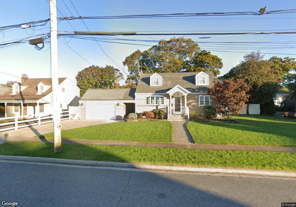
1927 Commonwealth Ave Merrick, NY 11566
Estimated Value: $656,000 - $685,273
--
Bed
1
Bath
1,275
Sq Ft
$526/Sq Ft
Est. Value
About This Home
This home is located at 1927 Commonwealth Ave, Merrick, NY 11566 and is currently estimated at $670,637, approximately $525 per square foot. 1927 Commonwealth Ave is a home located in Nassau County with nearby schools including Merrick Avenue Middle School, Sanford H Calhoun High School, and Grace Christian Academy.
Ownership History
Date
Name
Owned For
Owner Type
Purchase Details
Closed on
Jan 28, 2005
Sold by
Prete John
Current Estimated Value
Create a Home Valuation Report for This Property
The Home Valuation Report is an in-depth analysis detailing your home's value as well as a comparison with similar homes in the area
Home Values in the Area
Average Home Value in this Area
Purchase History
| Date | Buyer | Sale Price | Title Company |
|---|---|---|---|
| -- | -- | -- |
Source: Public Records
Tax History Compared to Growth
Tax History
| Year | Tax Paid | Tax Assessment Tax Assessment Total Assessment is a certain percentage of the fair market value that is determined by local assessors to be the total taxable value of land and additions on the property. | Land | Improvement |
|---|---|---|---|---|
| 2025 | $13,751 | $453 | $260 | $193 |
| 2024 | $3,068 | $465 | $267 | $198 |
| 2023 | $12,368 | $493 | $283 | $210 |
| 2022 | $12,368 | $487 | $280 | $207 |
| 2021 | $15,200 | $534 | $307 | $227 |
| 2020 | $9,000 | $528 | $527 | $1 |
| 2019 | $2,371 | $565 | $564 | $1 |
| 2018 | $5,586 | $603 | $0 | $0 |
| 2017 | $5,570 | $638 | $631 | $7 |
| 2016 | $8,057 | $675 | $600 | $75 |
| 2015 | $2,589 | $713 | $577 | $136 |
| 2014 | $2,589 | $713 | $577 | $136 |
| 2013 | $2,594 | $751 | $607 | $144 |
Source: Public Records
Map
Nearby Homes
- 1894 Commonwealth Ave
- 1931 Miller Place
- 96 Thelma Ave
- 2291 Girard Place
- 2991 Girard Place
- 160 Bedford Ave
- 138 Hewlett Ave
- 131 Gregory Ave
- 1818 Gormley Ave
- 19 Margaret Blvd
- 49 Princeton Place
- 5 Oak Brook Ln
- 1690 Argyle Rd
- 1674 Birch Dr
- 103 Frankel Blvd
- 114 Frankel Blvd
- 174 Babylon Turnpike
- 1729 Gormley Ave
- 1800 Remson Ave
- 54 Beverly Rd
- 1921 Commonwealth Ave
- 1935 Commonwealth Ave
- 1915 Commonwealth Ave
- 30 Commonwealth Ave
- 1928 Smith St
- 81 Smith St
- 73 Smith St
- 1911 Commonwealth Ave
- 85 Smith St
- 1941 Commonwealth Ave
- 69 Smith St
- 2135 Jefferson St
- 1930 Commonwealth Ave
- 30 Jefferson St
- 1934 Commonwealth Ave
- 1918 Commonwealth Ave
- 22 Commonwealth Ave
- 1912 Commonwealth Ave
- 31 Commonwealth Ave