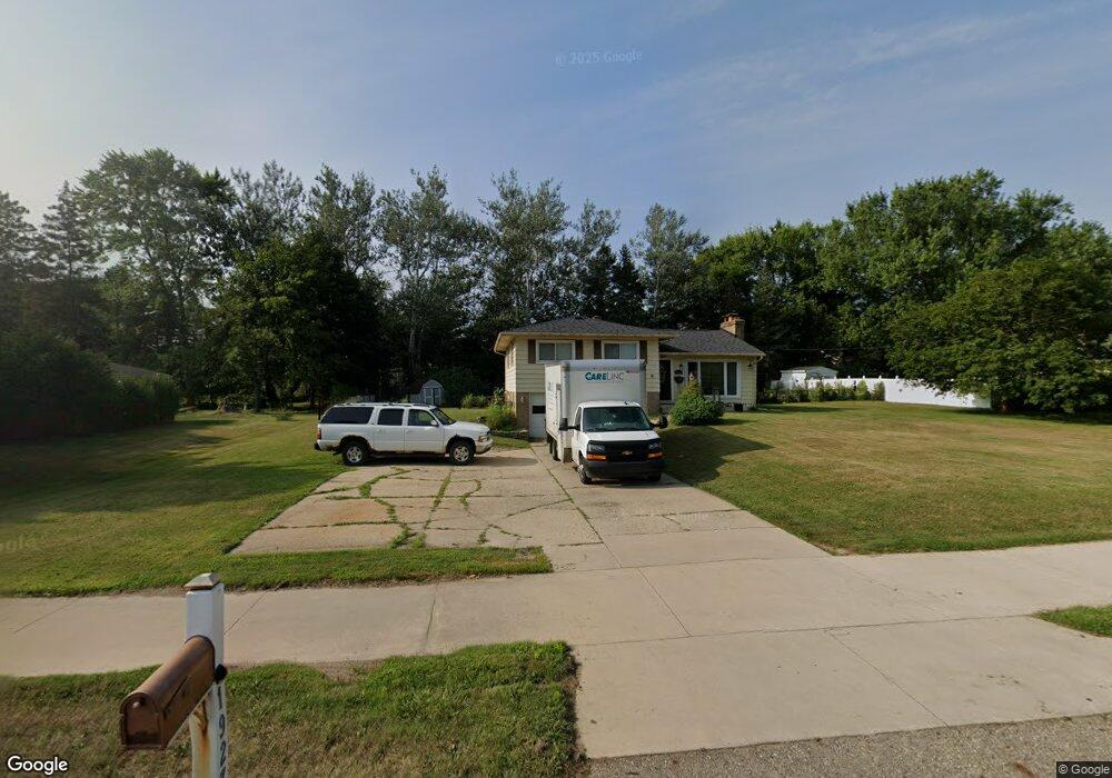
1927 Haslett Rd Haslett, MI 48840
Estimated Value: $220,000 - $265,000
3
Beds
1
Bath
1,339
Sq Ft
$178/Sq Ft
Est. Value
About This Home
This home is located at 1927 Haslett Rd, Haslett, MI 48840 and is currently estimated at $238,182, approximately $177 per square foot. 1927 Haslett Rd is a home located in Ingham County with nearby schools including Haslett High School and St Thomas Aquinas School.
Ownership History
Date
Name
Owned For
Owner Type
Purchase Details
Closed on
Jul 1, 2010
Sold by
Shock Jamie and Shock Micky
Bought by
Wells Fargo Bank Na
Current Estimated Value
Purchase Details
Closed on
Aug 2, 2004
Sold by
Nemeth Larry J and Nemeth Carol L
Bought by
Shock Jamie
Home Financials for this Owner
Home Financials are based on the most recent Mortgage that was taken out on this home.
Original Mortgage
$151,620
Interest Rate
6.34%
Mortgage Type
FHA
Purchase Details
Closed on
May 1, 1986
Create a Home Valuation Report for This Property
The Home Valuation Report is an in-depth analysis detailing your home's value as well as a comparison with similar homes in the area
Home Values in the Area
Average Home Value in this Area
Purchase History
| Date | Buyer | Sale Price | Title Company |
|---|---|---|---|
| Wells Fargo Bank Na | $170,521 | None Available | |
| Shock Jamie | $154,000 | Midstate | |
| -- | $62,500 | -- |
Source: Public Records
Mortgage History
| Date | Status | Borrower | Loan Amount |
|---|---|---|---|
| Previous Owner | Shock Jamie | $151,620 |
Source: Public Records
Tax History Compared to Growth
Tax History
| Year | Tax Paid | Tax Assessment Tax Assessment Total Assessment is a certain percentage of the fair market value that is determined by local assessors to be the total taxable value of land and additions on the property. | Land | Improvement |
|---|---|---|---|---|
| 2025 | $3,404 | $99,300 | $20,800 | $78,500 |
| 2024 | $15 | $95,300 | $22,000 | $73,300 |
| 2023 | $3,142 | $84,400 | $20,800 | $63,600 |
| 2022 | $3,046 | $70,600 | $16,600 | $54,000 |
| 2021 | $2,919 | $65,900 | $15,400 | $50,500 |
| 2020 | $2,872 | $65,400 | $15,400 | $50,000 |
| 2019 | $2,789 | $57,700 | $15,400 | $42,300 |
| 2018 | $2,657 | $57,000 | $16,000 | $41,000 |
| 2017 | $2,541 | $54,400 | $13,700 | $40,700 |
| 2016 | $1,158 | $50,700 | $12,200 | $38,500 |
| 2015 | $1,158 | $48,100 | $23,760 | $24,340 |
| 2014 | $1,158 | $48,700 | $23,100 | $25,600 |
Source: Public Records
Map
Nearby Homes
- 1922 Lac Du Mont Unit 3
- 5808 Okemos Rd Unit 38
- 2037 Lac Du Mont Unit 41
- Lot A Lake Lansing Rd
- Lot B Lake Lansing Rd
- 2209 Haslett Rd
- 5953 Village Dr
- 5989 Cypress St
- 5906 Marsh Rd
- 5581 Woodville Rd
- 5975 Everett Ln
- 5334 Haversham Dr
- 6120 Fresno Ln
- 6101 Sleepy Hollow Ln
- 6111 Fresno Ln
- 2446 S Wild Blossom Ct
- 5359 Wild Oak Dr Unit 54
- 5837 Carlton St
- 6248 W Reynolds Rd
- 5680 Deville Ct Unit 61
- 1917 Haslett Rd
- 1937 Haslett Rd
- 1930 Creek Landing
- 1934 Creek Landing Unit 60
- 1926 Creek Landing Unit 62
- 1915 Haslett Rd
- 1922 Creek Landing Unit 63
- 1938 Creek Landing Unit 59
- 1930 Haslett Rd
- 1944 Creek Landing Unit 58
- 1918 Creek Landing Unit 64
- 1914 Creek Landing Unit 65
- 1957 Haslett Rd
- 1909 Haslett Rd
- 1950 Creek Landing Unit 57
- 1910 Creek Landing Unit 66
- 1947 Creek Landing
- 1906 Creek Landing Unit 67
- 1905 Haslett Rd
- 1971 Haslett Rd