
Seller's Agent in 2025
Jason Bisson
Cottage & Co Real Estate
(207) 653-1188
2 in this area
166 Total Sales

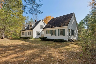
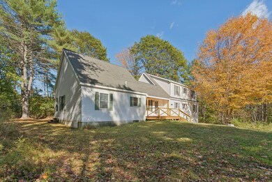
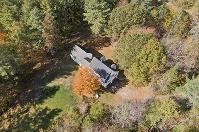
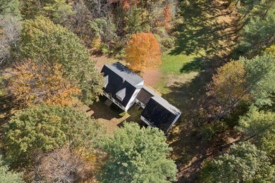
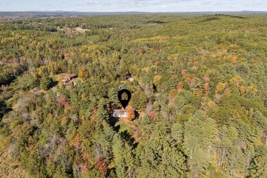
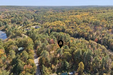
A classic Cape Cod tucked back off the road in the charming town of New Gloucester Maine. This 1 owner home has a very flexible layout consisting of 3 bedrooms and 2 bathrooms in the original Cape plus a 1 bedroom, 1 bathroom accessory dwelling unit (ADU) connected by a spacious breezeway. The ADU is perfect for multi-generational living, guest/studio/office space or for rental income to help pay the mortgage. The breezeway could be shared or can be exclusive to the home or the ADU. New flooring, a whole house generator, 1 floor living potential and the 2 car garage add to the appeal. The private 14.6 acre lot has abundant wildlife and abuts the pineland farms property and recreational trail system. Enjoy nature walks, trail runs, cross country skiing or hunting from your back yard. The seller used to clear the lot down to the brook and had a bridge over the brook to the back of the lot. The location is very quiet and peaceful, but it has easy access to Pineland market and recreational activities, local preserves and waterways or the interstate for access to Lewiston/Auburn, Freeport or Portland.
| Date | Type | Sale Price | Title Company |
|---|---|---|---|
| Warranty Deed | $670,000 | -- |
| Date | Event | Price | List to Sale | Price per Sq Ft |
|---|---|---|---|---|
| 11/04/2025 11/04/25 | Sold | $670,000 | -0.7% | $388 / Sq Ft |
| 10/17/2025 10/17/25 | Pending | -- | -- | -- |
| 10/14/2025 10/14/25 | For Sale | $675,000 | -- | $391 / Sq Ft |
| Year | Tax Paid | Tax Assessment Tax Assessment Total Assessment is a certain percentage of the fair market value that is determined by local assessors to be the total taxable value of land and additions on the property. | Land | Improvement |
|---|---|---|---|---|
| 2025 | $5,101 | $329,755 | $116,276 | $213,479 |
| 2024 | $4,910 | $329,755 | $116,276 | $213,479 |
| 2023 | $4,712 | $329,755 | $116,276 | $213,479 |
| 2022 | $4,551 | $329,755 | $116,276 | $213,479 |
| 2021 | $4,551 | $329,755 | $116,276 | $213,479 |
| 2020 | $9,273 | $329,755 | $116,276 | $213,479 |
| 2019 | $9,254 | $247,300 | $79,900 | $167,400 |
| 2018 | $3,591 | $247,300 | $79,900 | $167,400 |
| 2017 | $8,485 | $247,300 | $79,900 | $167,400 |
| 2016 | $3,635 | $247,300 | $79,900 | $167,400 |
| 2015 | $3,623 | $247,300 | $79,900 | $167,400 |
| 2014 | $3,586 | $247,300 | $79,900 | $167,400 |
| 2013 | $3,326 | $247,300 | $79,900 | $167,400 |
Seller's Agent in 2025
Jason Bisson
Cottage & Co Real Estate
(207) 653-1188
2 in this area
166 Total Sales
Buyer's Agent in 2025
Christopher Davis
Real Broker
(207) 756-2442
4 in this area
137 Total Sales
D
Buyer Co-Listing Agent in 2025
Dylan Letellier
Real Broker
(207) 272-3984
2 in this area
6 Total Sales
Source: Maine Listings
MLS Number: 1640731
APN: NEWG-000004-000000-000058
Disclaimer: Certain information contained herein is derived from information provided by parties other than Homes.com. All information provided is deemed reliable, but is not guaranteed to be accurate and should be independently verified.
![]() Listing data is derived in whole or in part from Maine Real Estate Information System, Inc. (d/b/a Maine Listings) and is for consumers' personal, noncommercial use only. Dimensions are approximate and not guaranteed. All data should be independently verified.
Listing data is derived in whole or in part from Maine Real Estate Information System, Inc. (d/b/a Maine Listings) and is for consumers' personal, noncommercial use only. Dimensions are approximate and not guaranteed. All data should be independently verified.
© 2025 Maine Real Estate Information System, Inc. All Rights Reserved. Equal Housing Opportunity.
Homes.com, LLC, 17600 Laguna Canyon Rd Irvine, CA 92618 (888)-952-6393
![]()