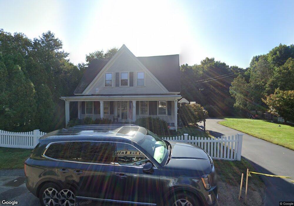
193 South St Wrentham, MA 02093
Estimated Value: $514,000 - $595,000
3
Beds
1
Bath
1,667
Sq Ft
$332/Sq Ft
Est. Value
About This Home
This home is located at 193 South St, Wrentham, MA 02093 and is currently estimated at $554,237, approximately $332 per square foot. 193 South St is a home located in Norfolk County with nearby schools including Delaney Elementary School and Charles E Roderick.
Ownership History
Date
Name
Owned For
Owner Type
Purchase Details
Closed on
Apr 15, 2025
Sold by
Verderber Paula J and Verderber Carl A
Bought by
Morrill Robert H and Morrill Mary D
Current Estimated Value
Purchase Details
Closed on
Oct 16, 2000
Sold by
Ellis Ruth K
Bought by
Verderber Paula J and Verderber Carl A
Home Financials for this Owner
Home Financials are based on the most recent Mortgage that was taken out on this home.
Original Mortgage
$171,000
Interest Rate
7.89%
Mortgage Type
Purchase Money Mortgage
Create a Home Valuation Report for This Property
The Home Valuation Report is an in-depth analysis detailing your home's value as well as a comparison with similar homes in the area
Home Values in the Area
Average Home Value in this Area
Purchase History
| Date | Buyer | Sale Price | Title Company |
|---|---|---|---|
| Morrill Robert H | $515,000 | None Available | |
| Morrill Robert H | $515,000 | None Available | |
| Verderber Paula J | $213,750 | -- |
Source: Public Records
Mortgage History
| Date | Status | Borrower | Loan Amount |
|---|---|---|---|
| Previous Owner | Verderber Paula J | $8,574 | |
| Previous Owner | Verderber Paula J | $273,707 | |
| Previous Owner | Verderber Paula J | $171,000 |
Source: Public Records
Tax History Compared to Growth
Tax History
| Year | Tax Paid | Tax Assessment Tax Assessment Total Assessment is a certain percentage of the fair market value that is determined by local assessors to be the total taxable value of land and additions on the property. | Land | Improvement |
|---|---|---|---|---|
| 2025 | $5,049 | $435,600 | $237,500 | $198,100 |
| 2024 | $5,090 | $424,200 | $237,500 | $186,700 |
| 2023 | $4,355 | $345,100 | $215,900 | $129,200 |
| 2022 | $4,776 | $349,400 | $210,000 | $139,400 |
| 2021 | $4,652 | $330,600 | $196,300 | $134,300 |
| 2020 | $4,130 | $289,800 | $149,800 | $140,000 |
| 2019 | $4,082 | $289,100 | $149,800 | $139,300 |
| 2018 | $4,249 | $298,400 | $149,900 | $148,500 |
| 2017 | $4,053 | $284,400 | $147,000 | $137,400 |
| 2016 | $4,017 | $281,300 | $142,800 | $138,500 |
| 2015 | $3,929 | $262,300 | $137,200 | $125,100 |
| 2014 | $3,893 | $254,300 | $132,000 | $122,300 |
Source: Public Records
Map
Nearby Homes
- 10 Nature View Dr
- 15 Nature View Dr
- 131 Creek St Unit 7
- 11 Earle Stewart Ln
- Lot 3 - 14 Earle Stewart Ln
- Lot 1 - Blueberry 2 Car Plan at King Philip Estates
- Lot 8 - Blueberry 2 Car Plan at King Philip Estates
- Lot 5 - Hughes 2 car Plan at King Philip Estates
- Lot 6 - Blueberry 3 Car Plan at King Philip Estates
- Lot 2 - Camden 2 Car Plan at King Philip Estates
- Lot 7 - Cedar Plan at King Philip Estates
- Lot 4 - Hemingway 2 Car Plan at King Philip Estates
- Lot 3 - Blueberry 2 Car Plan at King Philip Estates
- 319 Taunton St
- 1 Lorraine Metcalf Dr
- 570 Franklin St
- 270 Dedham St
- 155 Clark Rd Unit 155
- 362 East St
- 791 South St Unit 5
- LOT 10 Field Cir
- 150 Killdeer
- 138 Killdeer
- 190 South St
- 206 South St
- 209 South St Unit 2
- 216 South St
- 215 South St
- 176 South St
- 165 South St
- 15 Sumner Perry Dr
- 164 South St
- 224 South St
- 100 Randall Rd
- 185 South St
- 156 South St
- 155 South St
- 155 South St Unit 201
- 155 South St Unit 204
- 155 South St Unit 101-102