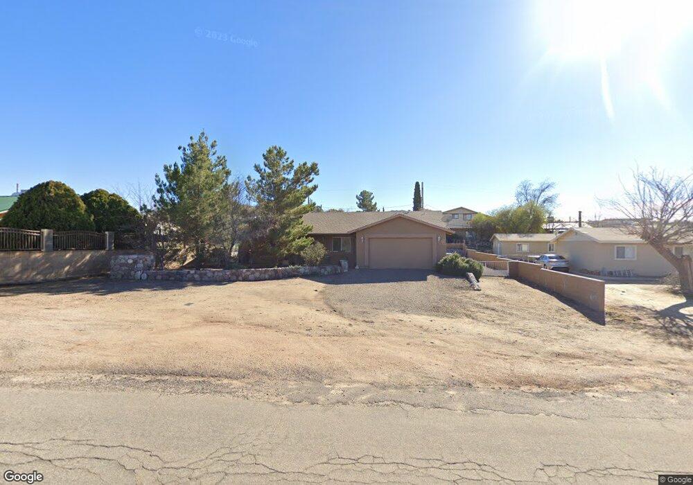
193 W Grant St Oracle, AZ 85623
Estimated Value: $310,000 - $420,000
3
Beds
2
Baths
1,646
Sq Ft
$226/Sq Ft
Est. Value
About This Home
This home is located at 193 W Grant St, Oracle, AZ 85623 and is currently estimated at $372,606, approximately $226 per square foot. 193 W Grant St is a home located in Pinal County with nearby schools including Mountain Vista School.
Ownership History
Date
Name
Owned For
Owner Type
Purchase Details
Closed on
Feb 22, 2014
Sold by
Bettcher William John and Bettcher Madonna R
Bought by
Contreras Elsa A
Current Estimated Value
Purchase Details
Closed on
Nov 30, 2009
Sold by
Bettcher William John and Bettcher Madonna R
Bought by
Gonzalez Virginia A
Home Financials for this Owner
Home Financials are based on the most recent Mortgage that was taken out on this home.
Original Mortgage
$127,920
Interest Rate
4.99%
Mortgage Type
New Conventional
Create a Home Valuation Report for This Property
The Home Valuation Report is an in-depth analysis detailing your home's value as well as a comparison with similar homes in the area
Home Values in the Area
Average Home Value in this Area
Purchase History
| Date | Buyer | Sale Price | Title Company |
|---|---|---|---|
| Contreras Elsa A | -- | None Available | |
| Gonzalez Virginia A | $159,900 | Title Security Agency Of Pin |
Source: Public Records
Mortgage History
| Date | Status | Borrower | Loan Amount |
|---|---|---|---|
| Previous Owner | Gonzalez Virginia A | $127,920 |
Source: Public Records
Tax History Compared to Growth
Tax History
| Year | Tax Paid | Tax Assessment Tax Assessment Total Assessment is a certain percentage of the fair market value that is determined by local assessors to be the total taxable value of land and additions on the property. | Land | Improvement |
|---|---|---|---|---|
| 2025 | $1,949 | $33,710 | -- | -- |
| 2024 | $1,843 | $36,237 | -- | -- |
| 2023 | $1,992 | $22,907 | $591 | $22,316 |
| 2022 | $1,843 | $18,087 | $591 | $17,496 |
| 2021 | $1,874 | $17,976 | $0 | $0 |
| 2020 | $1,838 | $16,426 | $0 | $0 |
| 2019 | $1,725 | $15,520 | $0 | $0 |
| 2018 | $1,643 | $14,908 | $0 | $0 |
| 2017 | $1,578 | $14,920 | $0 | $0 |
| 2016 | $1,637 | $15,280 | $591 | $14,688 |
| 2014 | -- | $7,412 | $592 | $6,821 |
Source: Public Records
Map
Nearby Homes
- 600 N Oak Hills Place
- 280 W Oak Hills Dr
- 999 N Calle Manzanita
- 745 N Las Flores Dr
- 0 W La Mariposa St Unit 22509508
- 2.5 ac W Oak Hills Dr Unit A
- 335 W Oak Hills Dr
- 325 W Oak Hills Dr
- 568 N Las Flores Dr
- TBD N Estill Dr Unit 9.54 AC
- 990 N Mountain View Dr
- 1 ac. N Blue Ridge Dr
- 540 N Redbud Place
- 275 W Rochette Rd NW
- 895 N Calle Futura
- 835 W Sunset Ave
- 850 W Sunset Point Cir
- 880 W Sunset Point Cir
- 330 N Estill Dr
- 0 N Unit 3
- 215 W Grant St
- 0 W Grant St Unit 5-8 21526323
- 0 W Grant St Unit 21505609
- 200 W Truman St
- 190 W Truman St
- 905 N Stewart Dr
- 245 W Truman St
- 215 W Truman St
- 935 N Sherman St
- 335 W Grant St
- 45 W Grant St
- 1055 N Hunter Cir
- 853 N Stewart Dr
- 25 W Grant St
- 1060 N Hunter Cir
- 940 N Estill Dr
- 35 E Maplewood St
- 810 N Stewart Dr
- 855 N Sherman Dr
- 15 E Grant St