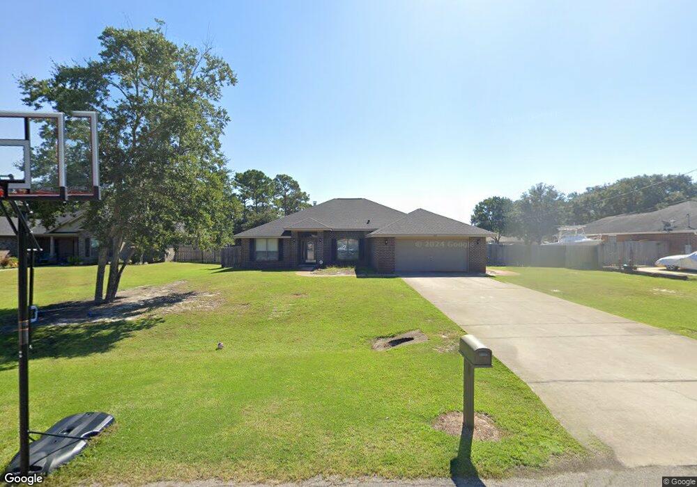
1930 Amhurst Ct Navarre, FL 32566
Estimated Value: $471,732 - $528,000
4
Beds
3
Baths
2,401
Sq Ft
$204/Sq Ft
Est. Value
About This Home
This home is located at 1930 Amhurst Ct, Navarre, FL 32566 and is currently estimated at $489,683, approximately $203 per square foot. 1930 Amhurst Ct is a home located in Santa Rosa County with nearby schools including West Navarre Primary School, West Navarre Intermediate School, and Woodlawn Beach Middle School.
Ownership History
Date
Name
Owned For
Owner Type
Purchase Details
Closed on
Jul 22, 2011
Sold by
Adans Homes Of Northwest Florida Inc
Bought by
Smith Jason D and Smith Christy L
Current Estimated Value
Home Financials for this Owner
Home Financials are based on the most recent Mortgage that was taken out on this home.
Original Mortgage
$244,650
Outstanding Balance
$168,391
Interest Rate
4.52%
Mortgage Type
VA
Estimated Equity
$321,292
Purchase Details
Closed on
Feb 3, 2011
Sold by
Kaether Fritz and Kaether Sylvia
Bought by
Adams Homes Of Northwest Florida Inc
Create a Home Valuation Report for This Property
The Home Valuation Report is an in-depth analysis detailing your home's value as well as a comparison with similar homes in the area
Home Values in the Area
Average Home Value in this Area
Purchase History
| Date | Buyer | Sale Price | Title Company |
|---|---|---|---|
| Smith Jason D | $236,900 | None Available | |
| Adams Homes Of Northwest Florida Inc | $40,000 | None Available |
Source: Public Records
Mortgage History
| Date | Status | Borrower | Loan Amount |
|---|---|---|---|
| Open | Smith Jason D | $244,650 |
Source: Public Records
Tax History
| Year | Tax Paid | Tax Assessment Tax Assessment Total Assessment is a certain percentage of the fair market value that is determined by local assessors to be the total taxable value of land and additions on the property. | Land | Improvement |
|---|---|---|---|---|
| 2025 | $205 | $236,606 | -- | -- |
| 2024 | -- | $229,938 | -- | -- |
| 2023 | $0 | $223,241 | $0 | $0 |
| 2022 | $0 | $216,739 | $0 | $0 |
| 2021 | $0 | $210,426 | $0 | $0 |
| 2020 | $0 | $207,521 | $0 | $0 |
| 2019 | $0 | $202,855 | $0 | $0 |
| 2018 | $0 | $199,073 | $0 | $0 |
| 2017 | $0 | $194,978 | $0 | $0 |
| 2016 | $0 | $190,968 | $0 | $0 |
| 2015 | -- | $189,641 | $0 | $0 |
| 2014 | $2,160 | $188,136 | $0 | $0 |
Source: Public Records
Map
Nearby Homes
- 1960 Amhurst Ct
- 2029 Colby Ct
- 2038 Colby Ct
- 1848 Lindsey Magnolia Ct
- 2061 Bahama Dr
- 2091 Alfred Blvd
- 7488 Harvest Village Ct
- 1983 Alfred Blvd
- 7409 Frankfort St
- 1739 Ivalea Cir
- 2038 Shannon Rd
- 1766 Sound Haven Ct
- 1754 Ivalea Cir
- 1777 Ravenna Dr
- 7376 Mulberry Ln
- 7924 Spitfire St
- 1938 Coral St
- 1726 Villa Vizcaya Dr
- 7292 Broadmoor St
- 1712 Sound Haven Ct
- 1968 Amhurst Ct
- 0 Amhurst Ct
- 1976 Amhurst Ct
- 1969 Amhurst Ct
- 1952 Amhurst Ct
- 1961 Amhurst Ct
- 1977 Amhurst Ct
- 1953 Amhurst Ct
- 1938 Amhurst Ct
- 1984 Amhurst Ct
- 1967 Hawthorne Dr
- 1942 Amhurst Ct
- 1959 Hawthorne Dr
- 1985 Amhurst Ct
- 1939 Amhurst Ct
- 1975 Hawthorne Dr
- 1945 Amhurst Ct
- 1983 Hawthorne Dr
- 1992 Amhurst Ct
- 1966 Alamanda Ct
Your Personal Tour Guide
Ask me questions while you tour the home.