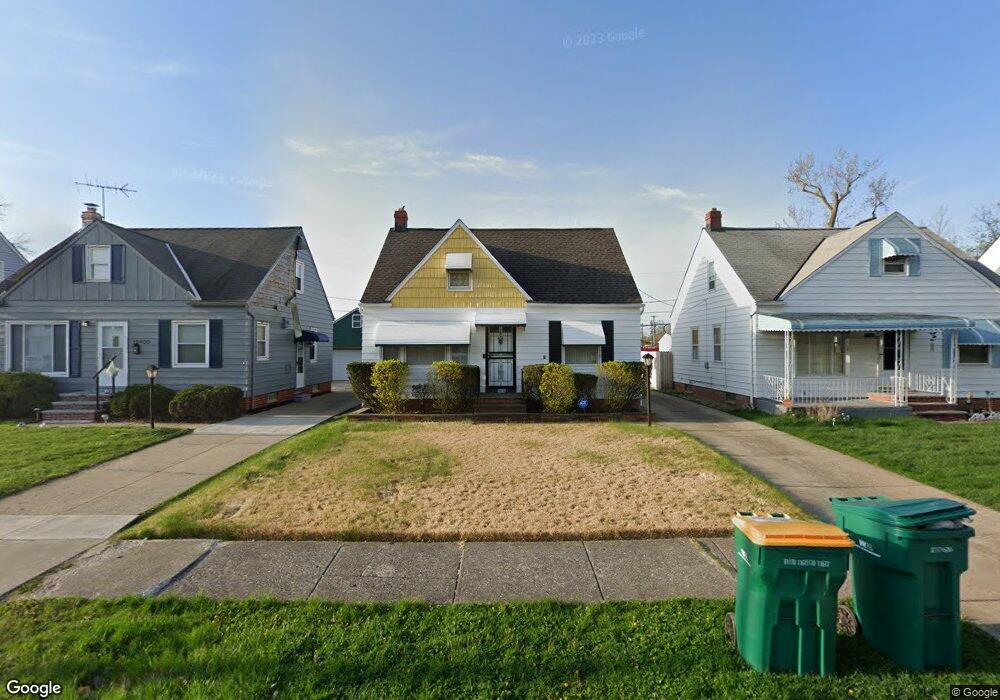
19316 Beverly Ave Maple Heights, OH 44137
Estimated Value: $96,000 - $127,000
3
Beds
2
Baths
1,092
Sq Ft
$107/Sq Ft
Est. Value
About This Home
This home is located at 19316 Beverly Ave, Maple Heights, OH 44137 and is currently estimated at $117,215, approximately $107 per square foot. 19316 Beverly Ave is a home located in Cuyahoga County with nearby schools including Abraham Lincoln Elementary School, Rockside/ J.F. Kennedy School, and Barack Obama School.
Ownership History
Date
Name
Owned For
Owner Type
Purchase Details
Closed on
Mar 8, 1996
Sold by
Ream Richard G
Bought by
Fipps Brian and Fipps Leatrice
Current Estimated Value
Home Financials for this Owner
Home Financials are based on the most recent Mortgage that was taken out on this home.
Original Mortgage
$61,600
Interest Rate
7.05%
Mortgage Type
New Conventional
Purchase Details
Closed on
Nov 1, 1993
Sold by
Ream Richard G
Bought by
Ream Richard G
Purchase Details
Closed on
Mar 13, 1992
Sold by
Pundt Mark R
Bought by
Ream Richard G
Purchase Details
Closed on
Jun 23, 1989
Sold by
Barbara A Sharpe
Bought by
Pundt Mark R
Purchase Details
Closed on
Dec 16, 1976
Sold by
Sharpe Richard E and Sharpe Barbara A
Bought by
Barbara A Sharpe
Purchase Details
Closed on
Jan 1, 1975
Bought by
Sharpe Richard E and Sharpe Barbara A
Create a Home Valuation Report for This Property
The Home Valuation Report is an in-depth analysis detailing your home's value as well as a comparison with similar homes in the area
Home Values in the Area
Average Home Value in this Area
Purchase History
| Date | Buyer | Sale Price | Title Company |
|---|---|---|---|
| Fipps Brian | $77,000 | -- | |
| Ream Richard G | -- | -- | |
| Ream Richard G | $60,000 | -- | |
| Pundt Mark R | $56,500 | -- | |
| Barbara A Sharpe | -- | -- | |
| Sharpe Richard E | -- | -- |
Source: Public Records
Mortgage History
| Date | Status | Borrower | Loan Amount |
|---|---|---|---|
| Closed | Fipps Brian | $61,600 |
Source: Public Records
Tax History
| Year | Tax Paid | Tax Assessment Tax Assessment Total Assessment is a certain percentage of the fair market value that is determined by local assessors to be the total taxable value of land and additions on the property. | Land | Improvement |
|---|---|---|---|---|
| 2025 | $4,199 | $38,675 | $6,720 | $31,955 |
| 2024 | $3,456 | $38,675 | $6,720 | $31,955 |
| 2023 | $2,620 | $24,960 | $4,800 | $20,160 |
| 2022 | $2,611 | $24,960 | $4,800 | $20,160 |
| 2021 | $2,786 | $24,960 | $4,800 | $20,160 |
| 2020 | $2,372 | $18,900 | $3,640 | $15,260 |
| 2019 | $2,361 | $54,000 | $10,400 | $43,600 |
| 2018 | $2,373 | $18,900 | $3,640 | $15,260 |
| 2017 | $2,580 | $20,620 | $4,730 | $15,890 |
| 2016 | $2,497 | $20,620 | $4,730 | $15,890 |
| 2015 | $2,514 | $20,620 | $4,730 | $15,890 |
| 2014 | $2,514 | $22,650 | $5,180 | $17,470 |
Source: Public Records
Map
Nearby Homes
- 19289 Stafford Ave
- 18909 Maple Heights Blvd
- 5409 Hollywood Ave
- 19520 Maple Heights Blvd
- 18715 Libby Rd
- 5357 Beechwood Ave
- 19910 Mountville Dr
- 5571 Oakwood Ave
- 18811 Waterbury Ave
- 5194 Homewood Ave
- 18717 Waterbury Ave
- 20111 Mountville Dr
- 5165 Camden Rd
- 18207 Mapleboro Ave
- 18217 Edinboro Ave
- 18990 Raymond St
- 5219 Joseph St
- 339 Grand Blvd
- 5147 Warrensville Center Rd
- 18851 Raymond St
- 19400 Beverly Ave
- 19312 Beverly Ave
- 19404 Beverly Ave
- 19308 Beverly Ave
- 19408 Beverly Ave
- 19304 Beverly Ave
- 19412 Beverly Ave
- 19300 Beverly Ave
- 19317 Beverly Ave
- 19401 Beverly Ave
- 19313 Beverly Ave
- 19405 Beverly Ave
- 19416 Beverly Ave
- 19216 Beverly Ave
- 19409 Beverly Ave
- 19305 Beverly Ave
- 19413 Beverly Ave
- 19500 Beverly Ave
- 19212 Beverly Ave
- 19248 Stafford Ave
Your Personal Tour Guide
Ask me questions while you tour the home.