
Seller's Agent in 2025
Frank Mastroianni
Real Estate One
(248) 912-5512
2 in this area
195 Total Sales
Estimated Value: $326,000 - $335,632
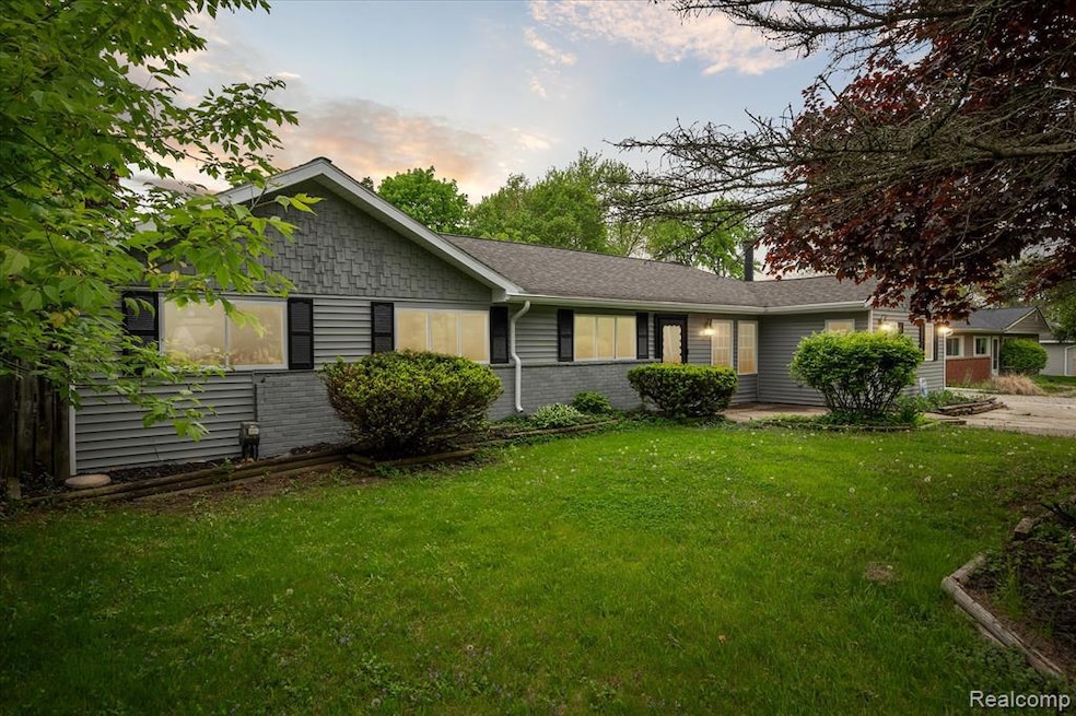
Beautiful 4-Bedroom Ranch with Modern Upgrades!
Welcome to this spacious 4-bedroom, 2-bath ranch offering 2,000 square feet of comfortable living. Featuring a fully updated kitchen with quartz countertops, stainless steel appliances, and soft-close cabinets, this home blends modern style with cozy charm. Enjoy the open floor plan, large bedrooms, and a private backyard—perfect for entertaining or relaxing. Don't miss this move-in-ready gem!
Agent is owner
Last Agent to Sell the Property
Real Estate One-Northville License #6501329185 Listed on: 05/29/2025
| Date | Buyer | Sale Price | Title Company |
|---|---|---|---|
| Miles Donell | $330,000 | None Listed On Document | |
| Miles Donell | $330,000 | None Listed On Document | |
| Mastroianni Frank | $180,000 | None Listed On Document | |
| Mastroianni Frank | $180,000 | None Listed On Document | |
| Tezak Alfred William | -- | None Available |
| Date | Status | Borrower | Loan Amount |
|---|---|---|---|
| Open | Miles Donell | $324,022 | |
| Previous Owner | Mastroianni Frank | $55,000 | |
| Previous Owner | Mastroianni Frank | $176,000 |
| Date | Event | Price | List to Sale | Price per Sq Ft |
|---|---|---|---|---|
| 08/21/2025 08/21/25 | Sold | $330,000 | -1.5% | $147 / Sq Ft |
| 06/28/2025 06/28/25 | Pending | -- | -- | -- |
| 06/05/2025 06/05/25 | Price Changed | $334,900 | -8.2% | $149 / Sq Ft |
| 05/29/2025 05/29/25 | For Sale | $364,900 | -- | $162 / Sq Ft |
| Year | Tax Paid | Tax Assessment Tax Assessment Total Assessment is a certain percentage of the fair market value that is determined by local assessors to be the total taxable value of land and additions on the property. | Land | Improvement |
|---|---|---|---|---|
| 2024 | $2,181 | $149,080 | $0 | $0 |
| 2022 | $2,077 | $140,610 | $36,000 | $104,610 |
| 2021 | $2,774 | $119,770 | $0 | $0 |
| 2020 | $1,656 | $115,030 | $26,570 | $88,460 |
| 2018 | $2,656 | $98,990 | $21,000 | $77,990 |
| 2015 | -- | $80,610 | $0 | $0 |
| 2014 | -- | $74,470 | $0 | $0 |
| 2011 | -- | $72,070 | $0 | $0 |
Seller's Agent in 2025
Frank Mastroianni
Real Estate One
(248) 912-5512
2 in this area
195 Total Sales
Buyer's Agent in 2025
Larry Williams
Berkshire Hathaway HomeServices Kee Realty
(248) 651-1200
1 in this area
45 Total Sales
Source: Realcomp
MLS Number: 20251003058
APN: 18-05-253-017
Disclaimer: Certain information contained herein is derived from information provided by parties other than Homes.com. All information provided is deemed reliable, but is not guaranteed to be accurate and should be independently verified.
![]() IDX provided courtesy of Realcomp II Ltd. via Ten-X and MLS
IDX provided courtesy of Realcomp II Ltd. via Ten-X and MLS
Copyright 2025 Realcomp II Ltd. Shareholders
IDX information is provided exclusively for consumers' personal, noncommercial use and may not be used for any purpose other than to identify prospective properties consumers may be interested in purchasing. The accuracy of all information, regardless of source, is not guaranteed or warranted. All information should be independently verified.
Listing Information presented by local MLS brokerage: Ten-X, local REALTOR®- Arlene Richardson - (888)-952-6393