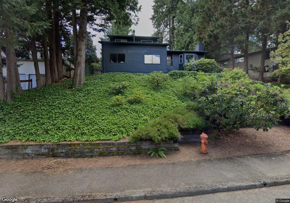
1932 SW Broadleaf Dr Portland, OR 97219
Marshall Park NeighborhoodEstimated Value: $754,318 - $816,000
4
Beds
3
Baths
2,567
Sq Ft
$307/Sq Ft
Est. Value
About This Home
This home is located at 1932 SW Broadleaf Dr, Portland, OR 97219 and is currently estimated at $787,580, approximately $306 per square foot. 1932 SW Broadleaf Dr is a home located in Multnomah County with nearby schools including Stephenson Elementary School, Jackson Middle School, and Ida B. Wells-Barnett High School.
Ownership History
Date
Name
Owned For
Owner Type
Purchase Details
Closed on
Jan 24, 2025
Sold by
Sinton William A and Ramroop-Sinton Candice
Bought by
Double Rainbow Trust and Sinton
Current Estimated Value
Purchase Details
Closed on
Oct 10, 2016
Sold by
Ritchie Brent T
Bought by
Sinton William A and Ramroop Sinton Candice
Home Financials for this Owner
Home Financials are based on the most recent Mortgage that was taken out on this home.
Original Mortgage
$416,000
Interest Rate
3.46%
Mortgage Type
New Conventional
Purchase Details
Closed on
Jun 23, 2011
Sold by
Ritchie Laura A
Bought by
Ritchie Brent T and Ritchie Laura A
Home Financials for this Owner
Home Financials are based on the most recent Mortgage that was taken out on this home.
Original Mortgage
$322,000
Interest Rate
4.25%
Mortgage Type
Adjustable Rate Mortgage/ARM
Purchase Details
Closed on
Sep 13, 2004
Sold by
Davis Laura A
Bought by
Davis Laura A and Ritchie Brent T
Home Financials for this Owner
Home Financials are based on the most recent Mortgage that was taken out on this home.
Original Mortgage
$40,000
Interest Rate
5.94%
Mortgage Type
Credit Line Revolving
Purchase Details
Closed on
Oct 29, 2001
Sold by
Odonnell Bobby John
Bought by
Odonnell Bobby John and Odonnell Laura A
Home Financials for this Owner
Home Financials are based on the most recent Mortgage that was taken out on this home.
Original Mortgage
$230,000
Interest Rate
6.84%
Mortgage Type
Purchase Money Mortgage
Purchase Details
Closed on
Mar 15, 1999
Sold by
Warren Robert L
Bought by
Odonnell Bobby John and Davis Laura
Home Financials for this Owner
Home Financials are based on the most recent Mortgage that was taken out on this home.
Original Mortgage
$230,850
Interest Rate
6.73%
Mortgage Type
Purchase Money Mortgage
Create a Home Valuation Report for This Property
The Home Valuation Report is an in-depth analysis detailing your home's value as well as a comparison with similar homes in the area
Home Values in the Area
Average Home Value in this Area
Purchase History
| Date | Buyer | Sale Price | Title Company |
|---|---|---|---|
| Double Rainbow Trust | -- | None Listed On Document | |
| Sinton William A | $541,000 | Wfg Title | |
| Ritchie Brent T | -- | First American | |
| Davis Laura A | -- | Pacific Nw Title | |
| Odonnell Bobby John | -- | Oregon Title Insurance Co | |
| Odonnell Bobby John | $243,000 | Chicago Title Insurance Co |
Source: Public Records
Mortgage History
| Date | Status | Borrower | Loan Amount |
|---|---|---|---|
| Previous Owner | Sinton William A | $416,000 | |
| Previous Owner | Ritchie Brent T | $322,000 | |
| Previous Owner | Davis Laura A | $40,000 | |
| Previous Owner | Odonnell Bobby John | $230,000 | |
| Previous Owner | Odonnell Bobby John | $230,850 |
Source: Public Records
Tax History Compared to Growth
Tax History
| Year | Tax Paid | Tax Assessment Tax Assessment Total Assessment is a certain percentage of the fair market value that is determined by local assessors to be the total taxable value of land and additions on the property. | Land | Improvement |
|---|---|---|---|---|
| 2025 | $11,496 | $427,060 | -- | -- |
| 2024 | $11,083 | $414,630 | -- | -- |
| 2023 | $11,083 | $402,560 | $0 | $0 |
| 2022 | $10,427 | $390,840 | $0 | $0 |
| 2021 | $10,250 | $379,460 | $0 | $0 |
| 2020 | $9,064 | $368,410 | $0 | $0 |
| 2019 | $9,051 | $357,680 | $0 | $0 |
| 2018 | $8,791 | $347,270 | $0 | $0 |
| 2017 | $8,425 | $337,160 | $0 | $0 |
| 2016 | $7,592 | $327,340 | $0 | $0 |
| 2015 | $7,357 | $317,810 | $0 | $0 |
| 2014 | $6,670 | $308,560 | $0 | $0 |
Source: Public Records
Map
Nearby Homes
- 9855 SW 25th Ave
- 1845 SW Taylors Ferry Rd
- 2249 SW Taylors Ferry Rd
- 9224 SW 26th Ave
- 0 SW Lancaster Rd Unit 722439051
- 0 SW Lancaster Rd Unit 540028719
- 0 SW Taylors Ferry Ct Unit 171663449
- 1345 SW Taylors Ferry Ct
- 9375 SW 8th Ave
- 10850 SW Creightonwood Place
- 9341 SW 8th Ave
- 2731 SW 28th Dr
- 9818 SW 34th Place
- 9822 SW 34th Place
- 9824 SW 34th Place
- 2531 SW Spring Garden St
- 8921 SW 7th Ave
- 1515 SW Carson St
- 9320 SW Boones Ferry Rd
- 2644 SW Hume Ct
- 1920 SW Broadleaf Dr
- 1940 SW Broadleaf Dr
- 10010 SW
- 10010 SW Balmer Cir
- 10014 SW Balmer Cir
- 1902 SW Broadleaf Dr
- 10006 SW Balmer Cir
- 1933 SW Broadleaf Dr
- 1937 SW Broadleaf Dr
- 10002 SW Balmer Cir
- 10018 SW Balmer Cir
- 1911 SW Broadleaf Dr
- 1850 SW Broadleaf Dr
- 1943 SW Broadleaf Dr
- 1905 SW Broadleaf Dr
- 10022 SW Balmer Cir
- 10007 SW Balmer Cir
- 10075 SW Balmer Cir
- 2001 SW Broadleaf Dr
- 1853 SW Broadleaf Dr