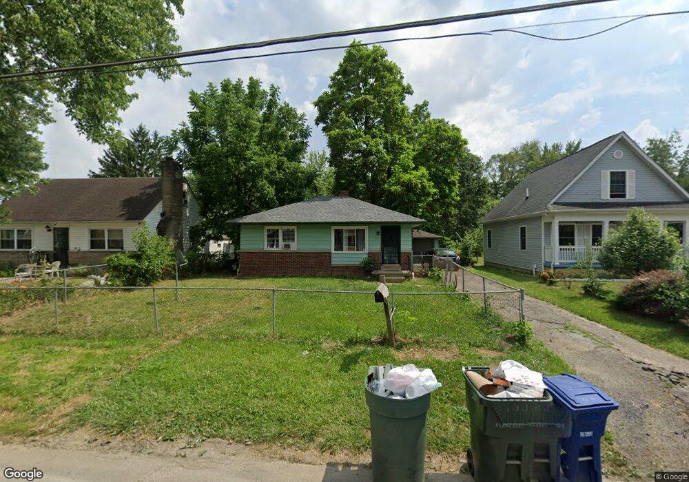
1933 Genessee Ave Columbus, OH 43211
East Linden NeighborhoodEstimated Value: $126,000 - $151,000
2
Beds
2
Baths
720
Sq Ft
$188/Sq Ft
Est. Value
About This Home
This home is located at 1933 Genessee Ave, Columbus, OH 43211 and is currently estimated at $135,430, approximately $188 per square foot. 1933 Genessee Ave is a home located in Franklin County with nearby schools including Linden STEM Academy (K-6), Linden-Mckinley Stem School On Arcadia, and Columbus Humanities Arts & Technology Academy.
Ownership History
Date
Name
Owned For
Owner Type
Purchase Details
Closed on
Sep 22, 2016
Sold by
Range Ozark
Bought by
Franklin County Treasuire
Current Estimated Value
Purchase Details
Closed on
Aug 5, 2016
Sold by
Range Ozark and Leonard Edward
Bought by
Ammar Mohammed Ghiath
Purchase Details
Closed on
Jul 8, 2009
Sold by
Estate Of Jacquellyn Yvonne Sowell
Bought by
Range Ozark
Purchase Details
Closed on
Apr 28, 1993
Bought by
Sowell Jacquellyn Y
Purchase Details
Closed on
Apr 1, 1985
Purchase Details
Closed on
Jan 1, 1985
Create a Home Valuation Report for This Property
The Home Valuation Report is an in-depth analysis detailing your home's value as well as a comparison with similar homes in the area
Home Values in the Area
Average Home Value in this Area
Purchase History
| Date | Buyer | Sale Price | Title Company |
|---|---|---|---|
| Franklin County Treasuire | -- | None Available | |
| Ammar Mohammed Ghiath | -- | None Available | |
| Range Ozark | -- | None Available | |
| Sowell Jacquellyn Y | $37,000 | -- | |
| -- | $28,500 | -- | |
| -- | $28,600 | -- |
Source: Public Records
Tax History Compared to Growth
Tax History
| Year | Tax Paid | Tax Assessment Tax Assessment Total Assessment is a certain percentage of the fair market value that is determined by local assessors to be the total taxable value of land and additions on the property. | Land | Improvement |
|---|---|---|---|---|
| 2024 | $1,284 | $28,010 | $8,510 | $19,500 |
| 2023 | $1,659 | $36,645 | $8,505 | $28,140 |
| 2022 | $744 | $14,000 | $2,450 | $11,550 |
| 2021 | $745 | $14,000 | $2,450 | $11,550 |
| 2020 | $746 | $14,000 | $2,450 | $11,550 |
| 2019 | $742 | $11,940 | $2,100 | $9,840 |
| 2018 | $786 | $11,940 | $2,100 | $9,840 |
| 2017 | $742 | $11,940 | $2,100 | $9,840 |
| 2016 | $938 | $13,800 | $2,910 | $10,890 |
| 2015 | $830 | $13,800 | $2,910 | $10,890 |
| 2014 | $832 | $13,800 | $2,910 | $10,890 |
| 2013 | $618 | $16,240 | $3,430 | $12,810 |
Source: Public Records
Map
Nearby Homes
- 1938 Myrtle Ave
- 1995 Minnesota Ave
- 2055 Earl Ave
- 2480 Parkwood Ave
- 1985 Aberdeen Ave
- 1799 Harold Place
- 00 Minnesota Ave
- 01 Minnesota Ave
- 1326 Minnesota Ave
- 2096 Minnesota Ave
- 1967 Denune Ave
- 1864 E Hudson St
- 2040 Loretta Ave
- 0 Parkwood Ave
- 2585 Perdue Ave
- 1609 Arlington Ave
- 2765 Joyce Ave
- 1615 Minnesota Ave
- 2771 Fern Ave
- 1669 Manchester Ave
- 1925 Genessee Ave
- 1919 Genessee Ave
- 1939 Genessee Ave
- 2447 Bretton Place
- 1955 Genessee Ave
- 2448 Bretton Place
- 1936 Genessee Ave
- 1930 Genessee Ave
- 1940 Genessee Ave
- 1926 Genessee Ave
- 2445 Bretton Place
- 1946 Genessee Ave
- 2456 Delbert Rd
- 1950-1952 Genessee Ave
- 1920 Genessee Ave
- 1950 Genessee Ave Unit 952
- 1950 Geneess Ave
- 2452 Delbert Rd
- 1965 Genessee Ave
- 1914 Genessee Ave