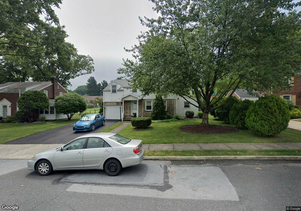
1933 Homestead Ave Bethlehem, PA 18018
West Bethlehem NeighborhoodEstimated Value: $395,802 - $437,000
4
Beds
2
Baths
1,709
Sq Ft
$242/Sq Ft
Est. Value
About This Home
This home is located at 1933 Homestead Ave, Bethlehem, PA 18018 and is currently estimated at $413,701, approximately $242 per square foot. 1933 Homestead Ave is a home located in Lehigh County with nearby schools including Clearview Elementary School, Nitschmann Middle School, and Liberty High School.
Ownership History
Date
Name
Owned For
Owner Type
Purchase Details
Closed on
Apr 18, 2008
Sold by
Anthony Monica M
Bought by
Krouse Jeffrey D
Current Estimated Value
Home Financials for this Owner
Home Financials are based on the most recent Mortgage that was taken out on this home.
Original Mortgage
$196,000
Outstanding Balance
$125,767
Interest Rate
6.22%
Mortgage Type
New Conventional
Estimated Equity
$287,934
Purchase Details
Closed on
Sep 6, 1980
Bought by
Anthony Edward J and Anthony Monica M
Create a Home Valuation Report for This Property
The Home Valuation Report is an in-depth analysis detailing your home's value as well as a comparison with similar homes in the area
Home Values in the Area
Average Home Value in this Area
Purchase History
| Date | Buyer | Sale Price | Title Company |
|---|---|---|---|
| Krouse Jeffrey D | $245,000 | -- | |
| Anthony Edward J | $73,500 | -- |
Source: Public Records
Mortgage History
| Date | Status | Borrower | Loan Amount |
|---|---|---|---|
| Open | Krouse Jeffrey D | $196,000 |
Source: Public Records
Tax History Compared to Growth
Tax History
| Year | Tax Paid | Tax Assessment Tax Assessment Total Assessment is a certain percentage of the fair market value that is determined by local assessors to be the total taxable value of land and additions on the property. | Land | Improvement |
|---|---|---|---|---|
| 2025 | $5,950 | $207,100 | $36,200 | $170,900 |
| 2024 | $5,882 | $207,100 | $36,200 | $170,900 |
| 2023 | $5,830 | $207,100 | $36,200 | $170,900 |
| 2022 | $5,925 | $207,100 | $170,900 | $36,200 |
| 2021 | $5,898 | $207,100 | $36,200 | $170,900 |
| 2020 | $5,710 | $207,100 | $36,200 | $170,900 |
| 2019 | $5,751 | $207,100 | $36,200 | $170,900 |
| 2018 | $5,639 | $207,100 | $36,200 | $170,900 |
| 2017 | $5,389 | $207,100 | $36,200 | $170,900 |
| 2016 | -- | $207,100 | $36,200 | $170,900 |
| 2015 | -- | $207,100 | $36,200 | $170,900 |
| 2014 | -- | $207,100 | $36,200 | $170,900 |
Source: Public Records
Map
Nearby Homes
- 922 Beverly Ave
- 1198 Pennsylvania Ave
- 1209 Manchester Rd
- 1826 Eaton Ave
- 1011 Highland Ave
- 1768 W Union Blvd
- 1853 Richmond Ave
- 2130 Glendale Ave
- 650 Highland Ave
- 820 Club Ave Unit 822
- 2180 Pinehurst Rd
- 1541 Stanford Rd
- 1102 N Van Buren St
- 1122 N Van Buren St
- 328 Grandview Blvd
- 1257 Troxell St
- 1509 W Union Blvd
- 1559 Kelchner Rd
- 1402 Uelen Ct
- 1556 Bayberry Ln
- 1939 Homestead Ave
- 1925 Homestead Ave
- 1938 Eaton Ave
- 1945 Homestead Ave
- 1915 Homestead Ave
- 1944 Eaton Ave
- 1930 Eaton Ave
- 1950 Eaton Ave
- 1907 Homestead Ave
- 1953 Homestead Ave
- 1922 Eaton Ave
- 1143 W Rosemont Dr
- 1920 Homestead Ave
- 1958 Eaton Ave
- 1140 W Rosemont Dr
- 1914 Homestead Ave
- 1146 W Rosemont Dr
- 1137 Beverly Ave
- 1960 Homestead Ave
- 1964 Eaton Ave