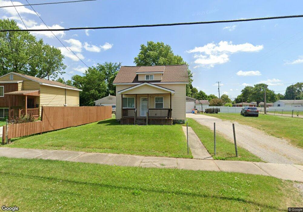
1933 Seymour Ave Flint, MI 48503
South Parks NeighborhoodEstimated Value: $46,000 - $63,000
2
Beds
1
Bath
752
Sq Ft
$75/Sq Ft
Est. Value
About This Home
This home is located at 1933 Seymour Ave, Flint, MI 48503 and is currently estimated at $56,503, approximately $75 per square foot. 1933 Seymour Ave is a home located in Genesee County with nearby schools including Freeman Elementary School, Flint Southwestern Classical Academy, and International Academy of Flint (K-12).
Ownership History
Date
Name
Owned For
Owner Type
Purchase Details
Closed on
Sep 28, 2021
Sold by
Pitts Charlie L
Bought by
Pitts Samuel James and Pitts Satyana
Current Estimated Value
Purchase Details
Closed on
Sep 1, 2010
Sold by
Sutton Darwin J
Bought by
Pitts Charlie and Pitts Maris
Purchase Details
Closed on
Jun 1, 2005
Sold by
Higginbotham Kim Renee
Bought by
Sutton Darwin Jay
Purchase Details
Closed on
Sep 16, 2002
Sold by
Hill Sharlene and Sutton Bryan K
Bought by
Higginbotham Kim R
Purchase Details
Closed on
Oct 20, 2000
Sold by
Sutton Audrey L and Hill Sharlene
Bought by
Sutton Audrey L and Hill Sharlene
Create a Home Valuation Report for This Property
The Home Valuation Report is an in-depth analysis detailing your home's value as well as a comparison with similar homes in the area
Home Values in the Area
Average Home Value in this Area
Purchase History
| Date | Buyer | Sale Price | Title Company |
|---|---|---|---|
| Pitts Samuel James | -- | None Listed On Document | |
| Pitts Charlie | -- | Cislo Title Company | |
| Sutton Darwin Jay | -- | -- | |
| Higginbotham Kim R | -- | -- | |
| Sutton Audrey L | -- | First American Title Ins Co |
Source: Public Records
Tax History Compared to Growth
Tax History
| Year | Tax Paid | Tax Assessment Tax Assessment Total Assessment is a certain percentage of the fair market value that is determined by local assessors to be the total taxable value of land and additions on the property. | Land | Improvement |
|---|---|---|---|---|
| 2025 | $561 | $18,400 | $0 | $0 |
| 2024 | $523 | $16,000 | $0 | $0 |
| 2023 | $522 | $13,600 | $0 | $0 |
| 2022 | $0 | $12,300 | $0 | $0 |
| 2021 | $622 | $10,500 | $0 | $0 |
| 2020 | $583 | $8,200 | $0 | $0 |
| 2019 | $579 | $7,500 | $0 | $0 |
| 2018 | $544 | $6,600 | $0 | $0 |
| 2017 | $533 | $0 | $0 | $0 |
| 2016 | $530 | $0 | $0 | $0 |
| 2015 | -- | $0 | $0 | $0 |
| 2014 | -- | $0 | $0 | $0 |
| 2012 | -- | $5,400 | $0 | $0 |
Source: Public Records
Map
Nearby Homes
- 1601 Wayne St
- 1917 Whittlesey St
- 1937 Chelan St
- 1840 Mcphail St
- 1110 Pingree Ave
- 2029 Aitken Ave
- 9211 Owen St
- 2010 Crocker Ave
- 2221 Howard Ave
- 1510 S Franklin Ave
- 2618 Pinetree Dr
- 2224 Crocker Ave
- 1409 S Franklin Ave
- 2121 Dwight Ave
- 2050 Ferris Ave
- 2313 Brookside Dr
- 420 Pingree Ave
- 1628 Broad Ct
- 2319 Calumet St
- 930 Belmont Ave
- 1929 Seymour Ave
- 1925 Seymour Ave
- 1934 Barks St
- 1930 Barks St
- 1617 Pingree Ave
- 1921 Seymour Ave
- 1926 Barks St
- 2001 Seymour Ave
- 1618 Wayne St
- 1613 Pingree Ave
- 1913 Seymour Ave
- 1922 Barks St
- 1917 Seymour Ave
- 1618 Pingree Ave
- 1609 Pingree Ave
- 1610 Wayne St
- 1918 Barks St
- 1909 Seymour Ave
- 2006 Barks St
- 1614 Pingree Ave