Estimated Value: $538,000 - $556,340
Studio
--
Bath
1,474
Sq Ft
$373/Sq Ft
Est. Value
About This Home
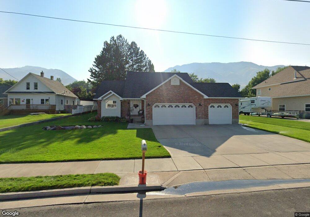
This home is located at 1934 N 1600 E, Logan, UT 84341 and is currently estimated at $550,085, approximately $373 per square foot. 1934 N 1600 E is a home with nearby schools including Greenville School, Cedar Ridge School, and North Cache Middle School.
Ownership History
Date
Name
Owned For
Owner Type
Purchase Details
Closed on
Feb 17, 2012
Sold by
Klimack Paul W and Klimack Kaye
Bought by
Klimack Paul and Klimack Kaye
Current Estimated Value
Home Financials for this Owner
Home Financials are based on the most recent Mortgage that was taken out on this home.
Original Mortgage
$212,100
Interest Rate
3.84%
Mortgage Type
New Conventional
Purchase Details
Closed on
Jan 26, 2007
Sold by
Klimack Kaye
Bought by
Klimack Paul W and Klimack Kaye
Home Financials for this Owner
Home Financials are based on the most recent Mortgage that was taken out on this home.
Original Mortgage
$16,000
Interest Rate
6.11%
Mortgage Type
Stand Alone Second
Create a Home Valuation Report for This Property
The Home Valuation Report is an in-depth analysis detailing your home's value as well as a comparison with similar homes in the area
Home Values in the Area
Average Home Value in this Area
Purchase History
| Date | Buyer | Sale Price | Title Company |
|---|---|---|---|
| Klimack Paul | -- | Cache Title Company | |
| Klimack Paul W | -- | Summit Title |
Source: Public Records
Mortgage History
| Date | Status | Borrower | Loan Amount |
|---|---|---|---|
| Closed | Klimack Paul | $212,100 | |
| Closed | Klimack Paul W | $16,000 |
Source: Public Records
Tax History
| Year | Tax Paid | Tax Assessment Tax Assessment Total Assessment is a certain percentage of the fair market value that is determined by local assessors to be the total taxable value of land and additions on the property. | Land | Improvement |
|---|---|---|---|---|
| 2025 | $2,225 | $311,385 | $0 | $0 |
| 2024 | $2,463 | $320,865 | $0 | $0 |
| 2023 | $2,452 | $298,865 | $0 | $0 |
| 2022 | $2,566 | $298,860 | $0 | $0 |
| 2021 | $2,252 | $406,710 | $60,000 | $346,710 |
| 2020 | $1,808 | $306,169 | $60,000 | $246,169 |
| 2019 | $1,894 | $306,169 | $60,000 | $246,169 |
| 2018 | $1,748 | $274,060 | $60,000 | $214,060 |
| 2017 | $1,697 | $140,030 | $0 | $0 |
| 2016 | $1,723 | $131,780 | $0 | $0 |
| 2015 | $1,478 | $119,635 | $0 | $0 |
| 2014 | $1,443 | $119,635 | $0 | $0 |
| 2013 | -- | $119,635 | $0 | $0 |
Source: Public Records
Map
Nearby Homes
- 2025 N 1550 E
- 1495 E 2300 N
- 1720 N 1850 E
- 1901 Southpointe Ct
- 1949 Deer Crest Cir Unit 49
- 1959 Deer Crest Cir
- 1586 N Sharptail Cir
- 1810 N 2070 E Unit 10
- 1100 E 1900 N Unit 10
- 1902 E 1500 N
- 1450 N 1525 E
- 1440 N 1600 E
- 1872 N 515 W
- 1454 N 1400 E
- 1593 N 110 W Unit 201
- 611 E 2450 N Unit 1
- 1593 N 110 W Unit 202
- 1593 N 110 W Unit 204
- 1200 W 1400 N
- 2950 N Mahogony Valley Rd E Unit 7
Your Personal Tour Guide
Ask me questions while you tour the home.