19344 Louis Rd Grass Valley, CA 95945
Estimated payment $575/month
Highlights
- Waterfront
- Many Trees
- Lot Has A Rolling Slope
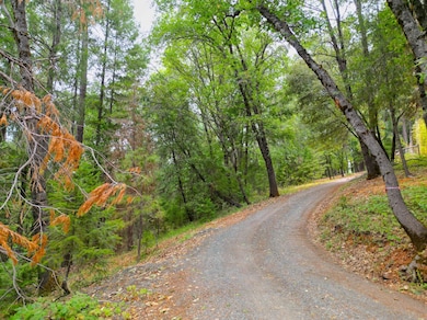
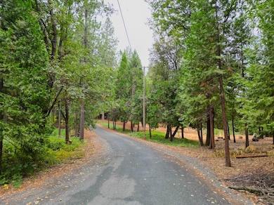
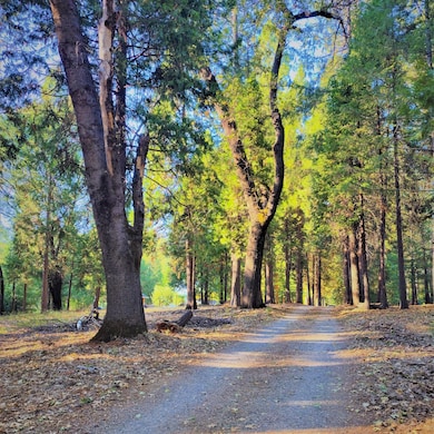
About This Lot
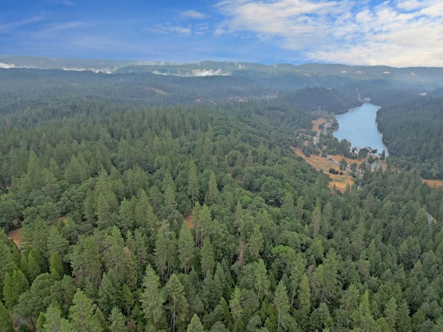
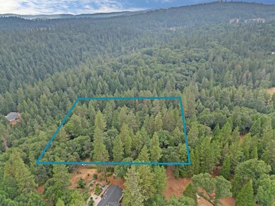
Lovely lot in that sweet spot of tree canopy where you can enjoy the conifers and black oaks! This is a great neighborhood near Rollins Lake for the water sports enthusiast. Paved road, easy access to Hwy 174 without the noise, upscale homes, gentle enough for horses or ag, but estate enough to just build your dream house and enjoy all the recreational opportunities this gentle, sweet lot affords. 5 acres with privacy and serenity!
Land Specialist: Don Thorpe 408-404-5646
PROPERTY INFO:
Size (Acres): 5.00
APN: 012-641-031-000
Address: 19344 Louis Road, Grass Valley, CA 95945
County: Nevada
State: California
Activities: Fishing, Camping, Nature Viewing, Boating
Zoning: Agriculture
Can I Build a House: Yes
Mobile Home Permitted: Yes
RV and Camping: Allowed with limitations
Utilities:
Power: Overhead utilities, in the area
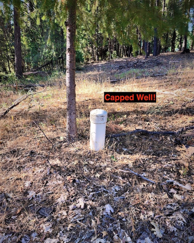
Water: Existing Well
Sewer: Septic System Required, No soil analysis on file
Terrain: Rolling
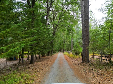
Road Condition: Gravel/Rock
Elevation: 2550 feet
Title Info: Purchased with title insurance
Annual Property Taxes (Approx): $2,023.00
Flood Zone/Wetlands: Blue Line Stream
HOA: This is not in an HOA
Lot Dimensions:
498.28 feet North of the property
456.30 feet West of the property
494.75 feet South of the property
445.01 feet East of the property
GPS:
39.1740369202563, -120.961229035856
39.1740421488399, -120.959538368762
39.1752534851706, -120.959417755562
39.175274436746, -120.96117199014
SKU: #DVL-784621

Property Details
Property Type
- Land
Est. Annual Taxes
- $824
Lot Details
- Waterfront
- Lot Has A Rolling Slope
- Many Trees
- Current uses include agriculture, residential single, timber
- Potential uses include agriculture, mobile, residential single
Utilities
- Overhead Utilities
- Well
Additional Features
- Water Views
- Wildlife includes quails, turkeys, doves
Map
Home Values in the Area
Average Home Value in this Area
Tax History
| Year | Tax Paid | Tax Assessment Tax Assessment Total Assessment is a certain percentage of the fair market value that is determined by local assessors to be the total taxable value of land and additions on the property. | Land | Improvement |
|---|---|---|---|---|
| 2025 | $824 | $76,500 | $76,500 | -- |
| 2024 | $1,150 | $75,000 | $75,000 | -- |
| 2023 | $1,150 | $106,080 | $106,080 | $0 |
| 2022 | $1,140 | $104,000 | $104,000 | $0 |
| 2021 | $1,115 | $101,961 | $101,961 | $0 |
| 2020 | $1,114 | $100,916 | $100,916 | $0 |
| 2019 | $1,069 | $98,938 | $98,938 | $0 |
| 2018 | $1,065 | $96,999 | $96,999 | $0 |
| 2017 | $1,023 | $95,098 | $95,098 | $0 |
| 2016 | $986 | $93,234 | $93,234 | $0 |
| 2015 | $973 | $91,834 | $91,834 | $0 |
| 2014 | $958 | $90,036 | $90,036 | $0 |
Property History
| Date | Event | Price | Change | Sq Ft Price |
|---|---|---|---|---|
| 09/10/2025 09/10/25 | Price Changed | $95,000 | -12.8% | -- |
| 09/05/2023 09/05/23 | For Sale | $109,000 | -- | -- |
Purchase History
| Date | Type | Sale Price | Title Company |
|---|---|---|---|
| Grant Deed | $75,000 | First American Title |
- 17911 Oak Way
- 17871 Rollins View Dr
- 14629 Rollins Park Dr
- 14008 Sontag Hill Rd
- 14833 Quail Pointe Ln
- 13999 Fifield Rd
- 17414 You Bet Rd
- 18510 You Bet Rd
- 14341 Arrowhead Mine Rd
- 13686 Sontag Rd
- 0 Nevada City Hwy Unit 225031820
- 14652 Carman Ct
- 14295 Arrowhead Mine Rd
- 14551 Cattail Ln
- 13709 Capitol Dr
- 14482 Cattail Ln
- 14173 Tahoe View Dr
- 14115 Tahoe View Dr
- 14421 You Bet Rd
- 13376 Capitol Dr
- 11683 View Dr
- 40 Sunrise Ave Unit 1
- 14714-B Gold Creek Ct
- 310 S Auburn St
- 15146 Nugget St
- 131 Eureka St
- 126 W Berryhill Dr
- 600 Packard Dr
- 10877 Morning Star Ln
- 18833 Rock Creek Rd
- 4444 Rock Creek Rd
- 20235 Paoli Ln Unit 20245 downstairs
- 3550 Nancy Dr Unit Crows Nest
- 15395 Lake Arthur Rd
- 15395 Lake Arthur Rd
- 11321 Joeger Rd
- 3639 Galena Dr Unit 1
- 11325 Quartz Dr
- 1938 Chimney Flat Ct
- 11490 Black Falcon Dr