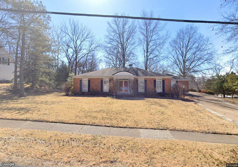
1936 Dougherty Ferry Rd Saint Louis, MO 63122
Estimated Value: $621,048 - $719,000
3
Beds
2
Baths
1,936
Sq Ft
$353/Sq Ft
Est. Value
About This Home
This home is located at 1936 Dougherty Ferry Rd, Saint Louis, MO 63122 and is currently estimated at $683,262, approximately $352 per square foot. 1936 Dougherty Ferry Rd is a home located in St. Louis County with nearby schools including Westchester Elementary School, North Kirkwood Middle School, and Kirkwood Senior High School.
Ownership History
Date
Name
Owned For
Owner Type
Purchase Details
Closed on
Jul 31, 2023
Sold by
Drysdale Jack C
Bought by
Indenture Of Trust and Drysdale
Current Estimated Value
Purchase Details
Closed on
May 16, 1997
Sold by
Mcniff Lucille E and Mcniff Earnest C
Bought by
Drysdale Jack C and Drysdale Billie Jo
Purchase Details
Closed on
Jan 16, 1997
Sold by
Mcniff Lucille E
Bought by
Mcniff Lucille E and Lucille E Mcniff Revocable Trust
Create a Home Valuation Report for This Property
The Home Valuation Report is an in-depth analysis detailing your home's value as well as a comparison with similar homes in the area
Home Values in the Area
Average Home Value in this Area
Purchase History
| Date | Buyer | Sale Price | Title Company |
|---|---|---|---|
| Indenture Of Trust | -- | None Listed On Document | |
| Drysdale Jack C | -- | -- | |
| Mcniff Lucille E | -- | -- | |
| Mcniff Lucille E | -- | -- |
Source: Public Records
Tax History Compared to Growth
Tax History
| Year | Tax Paid | Tax Assessment Tax Assessment Total Assessment is a certain percentage of the fair market value that is determined by local assessors to be the total taxable value of land and additions on the property. | Land | Improvement |
|---|---|---|---|---|
| 2025 | $5,989 | $112,900 | $72,090 | $40,810 |
| 2024 | $5,989 | $95,780 | $49,570 | $46,210 |
| 2023 | $5,895 | $95,780 | $49,570 | $46,210 |
| 2022 | $5,555 | $84,190 | $49,570 | $34,620 |
| 2021 | $5,483 | $84,190 | $49,570 | $34,620 |
| 2020 | $5,467 | $80,720 | $39,600 | $41,120 |
| 2019 | $5,485 | $80,720 | $39,600 | $41,120 |
| 2018 | $4,381 | $56,870 | $26,200 | $30,670 |
| 2017 | $4,375 | $56,870 | $26,200 | $30,670 |
| 2016 | $4,026 | $52,710 | $22,780 | $29,930 |
| 2015 | $4,006 | $52,710 | $22,780 | $29,930 |
| 2014 | $4,669 | $60,160 | $23,450 | $36,710 |
Source: Public Records
Map
Nearby Homes
- 1612 Dougherty Ferry Rd
- 2002 Woodland Knoll
- 2005 Woodland Knoll
- 2017 Woodland Knoll
- 2033 Woodland Knoll
- 2025 Woodland Knoll
- 1800 W Adams Ave
- 467 Tree Top Ln
- 591-593 N Ballas Rd
- 698 Trailcrest Ct Unit 5
- 340 S Ballas Rd
- 1312 W Essex Ave
- 2000 Trailcrest Ln Unit 3
- 1710 Lynkirk Ln
- 512 Bryan Ave
- 2037 Trailcrest Ln Unit 7
- 1912 Windy Hill Rd
- 2145 Trailcrest Dr
- 1314 W Adams Ave
- 2029 Lily Ave
- 368 Rieth Terrace
- 1954 Dougherty Ferry Rd
- 1935 Dougherty Ferry Rd
- 1927 Dougherty Ferry Rd
- 360 Rieth Terrace
- 1921 Dougherty Ferry Rd
- 1955 Dougherty Ferry Rd
- 1917 Dougherty Ferry Rd
- 1960 Dougherty Ferry Rd
- 369 Rieth Terrace
- 1961 Dougherty Ferry Rd
- 1903 Dougherty Ferry Rd
- 416 Rieth Terrace
- 1964 Dougherty Ferry Rd
- 355 Rieth Terrace
- 1970 Dougherty Ferry Rd
- 2000 Rieth Terrace
- 354 Rieth Terrace
- 1821 Dougherty Ferry Rd
- 428 Rieth Terrace